Grand Canyon National Park - Arizona
South Kaibab Trail - River Trail - Bright Angel Trail
After living in Arizona for 6 months, I felt as if I had grossly neglected one of the state's (and country's) most popular and magnificent treasures -- the Grand Canyon. So with the heat from the summer expired (yes, 90s is "cooled down" for a Phoenician), I entreated my most consistent and most "in shape" hiking buddy, Monica, to hike the Grand Canyon with me, which wasn't hard because she would rather hike than go to Disneyland.
Since I was a novice on Grand Canyon operations, I wanted to camp in the Canyon two nights and spend the days doing hikes that wouldn't kill me. However, I quickly learned that camping in the Canyon was a bit trickier than that. One is required to obtain a permit at least 4 to 6 weeks in advance (4 to 6 months is more realistic).
Information required on the application for the permit includes the names of the people camping, license plates of the automobiles to be driven to the Canyon, and the itinerary of all of the hikers. And the people operating the Grand Canyon want this information HOW LONG in advance? Come on! I am in my 20s! I am incapable of committing to anything 4 to 6 weeks in advance -- much less anything 4 to 6 months in advance.
So alas, we consigned ourselves to a day hike of about 18 miles. And again, being the novice, I chose the trails we would hike. After spending the night in Flagstaff, we arrived early at the South Rim entrance. First of all, I have to tell you -- of all of the pictures and IMAX films I have seen of the Grand Canyon, I was truly surprised by how many trees and how GREEN the Grand Canyon was! I was really expecting a big barren red hole! But trees were everywhere! And the panorama over the edge of the rim was overwhelming.
We parked near El Tovar Lodge, only because we couldn't get any closer to Bright Angel Lodge. We wanted to start our hike from Yaki Point at the South Kaibab Trailhead [a few miles east of Bright Angel], and hike back up Bright Angel Trail, which emerges at Bright Angel Lodge. So we took the free shuttle bus, which 45 minutes later took us to within 2 miles of the trailhead. We hiked from there until reaching Yaki Point [elevation 7,262 feet].
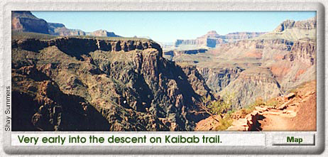
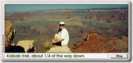
Once there, looking over the edge of the Grand Canyon is amazing, breath-taking, and unbelievable! But I didn't get a true feel for how large and astounding the Grand Canyon is until I started to hike INTO it. Because South Kaibab Trail [6.3-miles to the bottom] is one of the few trails in the park that follows the ridge lines instead of the canyons, it is VERY steep. This allowed us to see up the top and below to the bottom almost the whole way. In fact, just a few hundred yards into the descent, we saw the Colorado River almost a mile below.
It did make me feel like I had been thrust into the middle of the Canyon very quickly. The trail was not on the edge of a sheer cliff drop-off, but injury was certainly likely if one took a tumble off the trail!. The terrain is rugged, but the trail is well groomed. Kaibab Trail has two pit stops but no drinkable water refilling stations. Oh, and those little greenish dots that are sometimes visible on the other side of the Canyon -- well, they are trees.
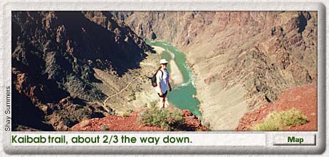
As we descended further, we encountered markers that had been placed by the Park Service providing geology lessons as we passed from one layer of rock [geological formation] to another layer. The two changes that stuck me the most were a brief white strip [Coconino Sandstone] that contrasted sharply against the bright red layer below it [Hermit Shale]; the other was an area near the bottom where lava [diabase sills] had filled fissures of previous rock formations [Hakatai Shale] leaving a striking vertical red-and-black striped pattern. All together, in our hike from top to bottom, we traveled 6.7 miles, 5,000 vertical feet and 1.5 billion years of geological history.
Upon reaching the bottom, we crossed over the Colorado River on a suspension foot bridge. Once on the north side, the trail runs west to where we stumbled upon an Anasazi Indian site -- I mean, we stopped and looked. We really didn't go tripping through this beautiful archeological find -- it's roped off. Only the foundation of some buildings and some old stone tools remained. The Anasazi were the ancestors of the Hopi and other modern Pueblo Indians.
Further along River Trail, we came upon a marker relating the adventures of Captain John Wesley Powell, [for whom Lake Powell is named] the leader of the first expedition to explore the Grand Canyon Gorge. Powell, who had only one arm due to a Civil War injury, accomplished this amazing feat by traveling in small boats down the Colorado River.
Monica expanded on this story by relating how 3 members of Powell's expedition lacked sufficient courage to continue their descent of the rapids, fearing all the boats would be lost and all the men would drown. They refused to continue and attempted to hike out of the Canyon. A couple of the river craft were, in fact, destroyed, but the only men to perish were those who had abandoned the expedition. That location, now called Separation Canyon, bears a plaque stating that on August 28, 1869, the 3 men "climbed to the North Rim and were killed by the Indians," who had been watching and following the expedition from above.
[John Wesley Powell went on to explore and map much of the Colorado Plateau. He was appointed the first director of the Smithsonian Institution Bureau of Ethnology in 1879 and also served as director of the U.S. Geological Survey from 1881 to 1892.]
After our pre-lunch archeology and history lessons, we arrived at Bright Angel Campground, on the south bank of Bright Angel Creek, which flows into the Colorado from the North Rim . [North Kaibab Trail, after passing Phantom Ranch, follows this creek almost to the top of the North Rim.]. The part of the campground we saw looked more like the remains of the OK Corral than a campground. And to put a little damper on the trip, the water line providing water to the campground from the North Rim was broken! Yikes! Luckily, we still had enough water from our descent to make it to the next potable water source.
After passing the restrooms [which had a public telephone!] we crossed back over the Colorado River via the second suspension foot bridge where we could see through the bottom directly into the river -- kind of cool. Once across the bridge, we found ourselves a few rocks to sit on, ate lunch, watched the river rafters go by, and rested.
Then we continued west for another mile or so. The trail remained level, and at first, we spent a lot of time walking along the river's edge through sand deposits left from centuries of water pounding on the rocks. Actually, all of the trails were rather sandy, much to my surprise. Thius was due, we later learned, to the many sandstone formations comprising Grand Canyon geology. Finally, Bright Angel Trail broke off to the left [south] and began ascending. Once we started UP the trail, we entered a whole new world!
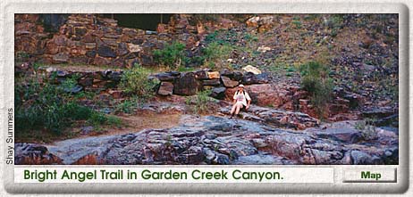
Bright Angel Trail follows Garden Creek which flows from the South Rim, running through its own little "mini" canyon within the Grand Canyon -- Garden Creek Canyon. We lost sight of the Colorado River pretty quickly. But Bright Angel Trail was so green! And the canyon was filled with cottonwood trees for miles of the trail, which crosses over Garden Creek several times.
One time, I crossed over the creek for a picture next to an old ranger station that was not in use anymore, or at least after the ummer months. The area looked like a scene described in a romance novel or a travel brochure. The creek was just shallow enough with little rocks perfectly protruding from the water to allow me to cross to the other side without getting my shoes the least bit damp. The little crooks in the red walls of the Canyon were filled in with young cottonwood trees providing ample shade and contrasting colors. Even the old ranger station looked like it was posing for a postcard picture.
During this part of the ascent, I had forgotten we had run into some fairly steep switchbacks because I was too busy looking around at the scenery. Also, I got a real kick out of looking down at the trail we had already climbed. There are apparently not many indigenous animal species viewable in the Grand Canyon because of the many people. But we saw big-eared deer -- I think they are really called mule deer -- and big-eared squirrels, too. I wanted to see some of the bighorn sheep to see if they had big ears, too, but none appeared.
During the hike, we were frequently passing or being passed by the same groups of people. I was glad to see that everyone kind of kept an eye out for their fellow hikers. When we were resting and refilling water at Indian Gardens, a wonderful little rest stop/campground [about 4.5 miles from the top], a woman we had several times passed and been passed by, arrived and told us another hiker was cramping up and out of water. She took him back some water -- and he wasn't even in the group she was hiking with. I thought that was so cool. Monica found someone else to play tennis with if she ever goes to Milwaukee. We also shared stories and information about other hikes in the Arizona/Utah area.
OK, I have to mention this guy because of his hair. He had basically made about the same hike we had -- we're talking about 14 miles at this point -- and his hair looked like he had just turned off the blow dryer. We waited until he had passed us after Indian Gardens and gawked and giggled in amazement! While we were at Indian Gardens, I was tempted to run my hands through it just to see if he had tons of hair spray in it or what.
About half a mile out of Indian Gardens, Monica down-shifted and started to increase the pace. "Wait a minute, we're going up really steep stuff!" But I found ways to slow her down. "Wait, I need to take a picture." -- breath, breath -- "My camel back is empty and I need to refill it." -- breath, breath -- And my personal favorite, "Cough, Cough, Cough, Cough. Ooops, there goes a lung." I really was recovering from a nasty cold so that wasn't much fun.
The last three miles of the hike were really amazing. Sometimes I wondered how we were going to get over that blankety blank cliff that was overhanging us. But then I would look at where we had come from. We saw the trail we had just hiked descending for miles -- well, it felt and looked like it. The last mile and a half, Mother Nature really saved the best for last and put on one of the most beautiful sunsets I have ever seen!
We were on the last set of switchbacks, so we were able to watch over our shoulder as the long rays of light from the sun were turning everything red, pink, and fuchsia. Cameras cannot capture what the eye can see. I had seen some of the rock formations before in pictures, but the splendor of the real thing is unbelievable. We arrived at the top just as the sun went down.
Hiking the Grand Canyon was an amazing experience. I recommend to anyone who has the ability to do it. One cannot see what the Grand Canyon is about from the top. Even if 18 miles isn't feasible, hike part way down and back up! The top half of Bright Angel Trail has drinkable water every 1.5 miles, so traveling light on this part of the trail is possible. If you do venture down toward the bottom, remember to drink a lot of water, to eat a sufficient amount of food, to pack your trash back out of the Grand Canyon, and to watch your step so you don't tread where the mules have been -- and yes, they have big ears, too!
Text and Photo by Shay Summers
Overview | Map | Description | Things
To Do | Camping/Lodging | Nearby
South Rim Hiking Trails | North Rim Hiking Trails
Points of Interest | Grand Canyon Adventure Tours
Related DesertUSA Pages
- How to Turn Your Smartphone into a Survival Tool
- 26 Tips for Surviving in the Desert
- Death by GPS
- 7 Smartphone Apps to Improve Your Camping Experience
- Maps Parks and More
- Desert Survival Skills
- How to Keep Ice Cold in the Desert
- Desert Rocks, Minerals & Geology Index
- Preparing an Emergency Survival Kit
- Get the Best Hotel and Motel Rates
Share this page on Facebook:
DesertUSA Newsletter -- We send articles on hiking, camping and places to explore, as well as animals, wildflower reports, plant information and much more. Sign up below or read more about the DesertUSA newsletter here. (It's Free.)
The Desert Environment
The North American Deserts
Desert Geological Terms


