The Borrego Badlands
Anza-Borrego Desert State Park California
Overview | Points of Interest | Where to Stay | Activities | Maps and Weather | Videos
In the Anza Borrego Desert of southeastern California lies a tract of land some 20 miles wide by 15 miles long, known as the Borrego Badlands. Once undersea, the region today is a maze of hills and arroyos which, when seen close-up, reveal a hidden treasure of native palms, remote springs and mysterious concretions. Click here for information on Font's Point.
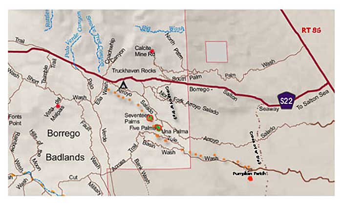
Our exploration of the Badlands began as we exited the S22 and followed the Arroyo Salado Wash east in our 4WD vehicle. Click here to watch a video of this story.
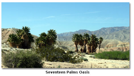
The first stop was Seventeen Palms Oasis, located off the Wash’s dirt road. This oasis has attracted humans for thousands of years and is a well-known watering hole for the regional wildlife of the Borrego Badlands. Though no watering holes were apparent while we were there, the palms at the oasis were green and brilliant compared to the stark and barren desert surrounding them.

As the spring here was unreliable, early travelers with extra water would leave it in large glass jars for others to find. Thirsty visitors came to rely on the jars hidden in the shade of the palms. The desert wanderers would leave notes attached to the jars. Today the custom of leaving messages in the prospector’s post office is carried on by visitors. In the post office barrel hidden in the 17 Palms, among the palm tree bases, lies a visitor’s log book, notes and of course, bottles of water!
We followed the Wash east after exploring the nearby Five Palms Oasis area. From there we switched over to the Tule Wash and continued east to the to the Pumpkin Patch cut off, which is marked with a sign.

Desert Magazine’s Jack Pepper first published an article about the Pumpkin Patch in 1970, showing a black and white picture of its concretions. I became interested, along with many others, in the Pumpkin Patch after seeing this wonderful photo by David Muench in the January 1981 edition of Desert Magazine.

The Patch’s unique landscape is the result of wind and water continuously eroding the surface soil to reveal these sandstone concretions.

Concretions are believed to be formed by the natural cementing of sand particles to small objects such as a piece of shell, a grain of sand or even an insect. On the nearby ridges, new pumpkin-sized concretions continue to grow and become exposed. Many come here just to see and photograph the area. The Pumpkin Patch, located within the Ocotillo Wells Off-Highway Vehicle Area, is an enclosed,protected area for everyone to enjoy.
The Borrego Badlands - Font's Point
Anza Borrego Desert State Park has seven unique areas and more than 600,000 acres of parkland that you can explore.
Anza /Visitor Center Area | Blair Valley Area | Bow Willow Area
Fish Creek Area | Santa Rosa Area | Tamarisk Grove Area | Activities

Related DesertUSA Pages
- How to Turn Your Smartphone into a Survival Tool
- 26 Tips for Surviving in the Desert
- Your GPS Navigation Systems
May Get You Killed
- 7 Smartphone Apps to Improve Your Camping Experience
- Desert Survival Skills
- Successful Search & Rescue Missions with Happy Endings
- How to Keep Ice Cold in the Desert
- Desert
Survival Tips for Horse and Rider
- Preparing
an Emergency Survival Kit
Share this page on Facebook:
The Desert Environment
The North American Deserts
Desert Geological Terms


Click here to see current desert temperatures!