Rio Grande River
Searching for El Dorado
by Joe Zentner
“Ride, boldly ride,” the shade replied, “if you seek for El Dorado.”
Edgar Allan Poe
El Dorado: Any place of fabulous wealth, scenery or opportunity, whether mineral or natural.
Even Poe’s shade might be taken aback when confronted with the fabulous scenic wealth of the Río Grande’s great bend region, an area the size of New England. Stand on the edge of the South Rim of the Chisos Mountains, in the heart of Texas’ Big Bend National Park. The land lies ageless before you: mountains to the east, the river to the south, and just beyond, Mexico.
A Wild and Scenic River
The Río Grande, Spanish for “Great River” – described by the National Park Service as “a relentless, gravity-powered belt sander that has been running for millions of years – has been designated by Congress a “Wild and Scenic” River. The fourth longest river in the U. S., the Río Grande rises near the Continental Divide in southwestern Colorado’s San Juan Mountains and flows nearly 1900 miles to the Gulf of Mexico. It symbolizes the spirit of the Big Bend’s arid range country, in essence, the quintessential landscape of Texas fable and legend and the setting for the epic mid-1950’s Texas movie, Giant, starring Hollywood giants Elizabeth Taylor, Rock Hudson and James Dean.
For 1,248 miles, the river marks the border between the United States and Mexico, from El Paso to Brownsville, Texas. For much of that distance it follows a course to the southeast. But where it passes the Chisos Mountains, the southernmost range in the U. S., it begins a long bend to the northeast before it turns southeast again. That bend provides a name and a southern boundary for the 800,000-acre Big Bend National Park. It helps define a region of Texas known for wide-open spaces, hot chili and resolutely independent people.
There are few truly “wild” portions of the river remaining, only two, in fact. One is the segment that flows through Big Bend National Park. The other is in north central New Mexico’s Río Grande Gorge, a stretch that became a part of the National Wild and Scenic River system on May 13, 1970.
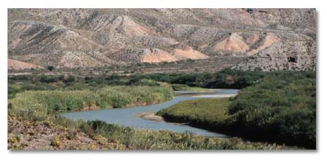
Along the Big Bend National Park boundary, the Río Grande, or Río Bravo del Norte (Spanish for “Rugged River of the North”) as border inhabitants call it, is a 107-mile stretch of winding turbid water with a startling mix of colors. Much of the river’s volume in Big Bend comes from the Río Conchos, which enters the Río Grande from Mexico, northwest of the park, just above Presidio, Texas. The river bottom provides a vivid relief of green amid the dusty muted yellows and reds of the desert mountains.
The Big Bend portion of the Río Grande remains untamed. Canyon walls rise, smooth and imposingly high above the river as it grinds away at the land. Much of the Río Grande was not successfully navigated until the 1890s, well after John Wesley Powell floated the fierce Colorado River. The Río Grande holds tight to its raw character and unpredictable nature.
What To See And Do
Highway 170, a wildly beautiful drive from Presidio to Lajitas, crosses a branch of the old Comanche War Trail, which was once used by smugglers, bandits, Texas Rangers and Indian raiding parties. Named “Camino del Río,” or the River Road, Highway 170 parallels the Río Grande, now flowing with waters from the Río Conchos, and cuts southeast through canyon and cliff.

From your vehicle, you can see the cottonwood and the feathery-leafed tamarisk (an aggressive invasive species) that signal the river’s presence long before you see water. The road grows steeper as the vista widens, and the views become overpowering. Layer upon layer of sedimentary rock rise hundreds of feet above the riverbed. You know that if man disappeared from the region, the land would simply remain indifferent. Cottonwoods would continue growing along the riverbanks, birds would continue calling from the trees, and the river would continue grinding through the earth. I suppose that the turkey vultures might notice the human absence and grieve. Roadkill makes for an easy meal.
As you drive, be prepared for steep grades as the road winds along, paralleling the river’s course through the canyons. Geology is still unfolding here, not with the spectacular suddenness of an erupting volcano, but with the relentless impact of erosion by water and wind. At normal levels, the river sculpts its bed. Floodwaters carve the canyon walls. Boulders, heaped like the contents from a giant’s marble bag, populate the river bottom below cliff faces.

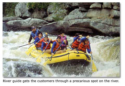
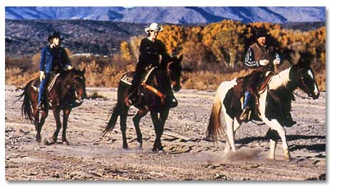
You can raft or kayak the Río Grande, ride a horse in the hills beside it, hike, camp, or bring your binoculars in spring or fall for some of the world’s best birding. If you choose to float the river by yourself, you’ll need a permit, which can be obtained from park headquarters and ranger stations. Inflatable rubber rafts or kayaks serve much better than rigid canoes or kayaks in the river’s swirling waters. The best months for river running are November through February.
Float Trip
My wife and I arranged a float trip down the Río Grande through Far Flung Adventures in Terlingua, TX. You can also arrange trips through Big Bend River Tours The beauty of a raft trip compared to hiking is that you don’t have to worry about water or food. Rafting companies provide all the necessities, even including a portable toilet, so that the river is left undisturbed. The guides row, cook, wash dishes and share with you the names and natural histories of the plants and wildlife.

The Río Grande rafting companies are allowed to transport only a limited number of passengers, including guides, per day. All the companies must have an operating permit, which is not easily obtained. Applicants must meet several requirements. They must, for example, know the river and its hazards. They must know something about the natural history. Also, a designated authority must approve their equipment and safety gear. This may seem like a lot of red tape, but it is red tape necessary to protect the safety of the passengers and assure the preservation of the river.

Floating in a rubber raft along the river at the bottom of Santa Elena Canyon, you see a towering architecture of rock and a dizzying distortion of perspective. The canyon walls, cut by the flowing waters over millions of years, rise as high as 1500 feet above you. During high water, the Río Grande carries literally tons of silt and sand that act like a cutting tool.
The toughest passage in Santa Elena Canyon comes early. The “Rock Slide,” a tumble of boulders the size of houses, blocks the channel. It is a problem when the water is high because of the turbulent currents. It is a problem when the water is low because the river is almost too shallow to permit passage of a raft.
It seems that there are always three routes through any rapids: the one where the river wants you to go, the one where the raft or boat wants you to go, and the one where the guide wants you to go. If all three coincide, the results are exhilarating, but not threatening. If the three fail to coincide, the river’s route automatically wins.
As we floated through Santa Elena Canyon, we watched a catfish lolling in the water. We passed an enormous swatch of brown and tan rock that almost looked like fabric but was subtler and more varied than the finest tweed. We slid past green salt cedar and river cane. We could see the deep blue V of the sky overhead. Red slider turtles drowsed on the rocks, slipping quietly into the water when we approached.
There is something special about moving with a river, giving in to it, going as it goes, hearing nothing but the hissing of white water, the call of canyon wrens, croaking ravens, and cooing white-winged doves. The Río Grande is always challenging and sublime, especially the passage through Santa Elena Canyon with its limestone cliffs, its occasional rapids, and its long veins of light as soft and diffuse as the glow of candles in a cathedral. It’s a supreme paradox, a river flowing majestically through a desert.
The rafting experience you have on the Río Grande depends on the season in which you go. Spring and fall, when the river can be high and fast, the rapids in Santa Elena Canyon – the most challenging stretch – can reach Class IV, enough to give any daredevil a run for his money. From June through August, the white water usually subsides, and what you get is a float trip.
Boquillas
After our river trip, we headed next for the Mexican village of Boquillas. At the river crossing, where there is no bridge, we encountered two Mexican boys with a boat. They were happy to haul us across for a couple of dollars. Everywhere we went in Boquillas, residents offered to sell us something—Coca-Cola, tequila, sombreros, ponchos. One man came over and pointed at his little restaurant and, in broken English, offered us eggs and cheese. Clearly, earning a living in Boquillas is hard, and with the exception of electricity, little has changed in a hundred years.
Hot Springs
A “don’t miss” river experience – one that is gentler than rafting (though that was hardly exhausting) – is Hot Springs. Drive southeast from Big Bend National Park headquarters at Panther Junction on Highway 118 toward Boquillas. In 13 miles, you’ll cross the Tornillo Creek bridge. Three-fourths of a mile later, look to your right for the gravel road to Hot Springs.
Hot springs bubble up through the river bottom in several places along the Río Grande. This particular location has been a gathering place for thousands of years. Early in the last century, a Mr. and Mrs. John Langford built a spa near the hot springs, and they lived there from 1909 to 1942. You can see the ruins of their house just west of the Hot Springs parking lot.
Hiking a nearby trail along the Río Grande, you'll see pictographs – prehistoric paintings on stone surfaces – rendered in red on limestone cliffs to your left. Rounding a bend, you will see in the river the remnants of concrete foundations, which enclose the Hot Springs outlet. R. A. Maxwell, first superintendent of Big Bend National Park, estimated that the spring flowed some 250,000 gallons per day with a temperature of 104 degrees F.
A hot spring isn’t just a geologic phenomenon. It can also be the venue for a social event. Bring a towel. Soak in the hot water with your friends. Splash in the cool river. Relax in the water with your eyes closed. It feels as good today as it did centuries ago.
With the sun setting and the temperature cooling, I lie in the hot springs, anchoring my feet in the soothing waters, my arms outstretched, my head back, watching the darkening sky. The only sound is the Río Grande rippling over smooth stones, while overhead amid the stars that are appearing in profusion in the darkening clear desert sky, I can make out the small, hazy smudge of light that is Andromeda, a galaxy far greater in size than our own Milky Way.
At a time when true wildness and isolation shrink just as our demand and need for them swell, Río Grande country remains unrelentingly wild and isolated, a place with few people. Radio signals fade in and out. The solitude can be profound.
The last night we spent beside the Río Grande, I lay in my sleeping bag at our camp. Coyotes howled from the Mexican shore. The stars spread across the black desert sky. I tried to stay awake, to take it all in. But I couldn’t. The coyotes went quiet. A breeze came down the canyon. I dozed off. The last thing I heard was the sweet music of the river flowing. El Dorado.
Getting There
Most people go to Big Bend and the Río Grande by way of Alpine or Marathon. You can also follow U. S. Highway 67 from Marfa to Presidio and then follow Highway 170, my favorite route to Lajitas and the park. Park headquarters at Panther Junction is located more than 100 miles from Alpine, which has the nearest Amtrak and bus depot. It is 220 miles from Odessa/Midland, which has the nearest commercial airport. From El Paso, the drive to Alpine is 223 miles. You head east on Interstate 10 to Van Horn, then turn on U. S. Highway 90 to Alpine. From San Antonio, the drive to Alpine is 300 miles. You take I-10 west and U. S. Highway 67 out of Fort Stockton south to Alpine.
When To Go
The best time to visit the Big Bend is from October through December, when the air turns cool at dusk and the leaves change color up in the Chisos, or from early March through mid-May, when many of the desert plants are in bloom. June is the hottest month. Temperatures can rise well over 100 degrees Fahrenheit at lower elevations.
Chisos Mountain Lodge is operated by National Park Concessions, Inc.
Other stories about the area.
Lajitas, Texas:
Share this page on Facebook:
The Desert Environment
The North American Deserts
Desert Geological Terms


Click here to see current desert temperatures!