Palm Springs Aerial Tramway
Palm Springs, CA
by Bob Katz
If you're like me, you've driven Interstate 10 many times and passed right by the Palm Springs Aerial Tramway sign just west of this most-famous desert home of the Fords, the Bonos, the Hopes and other retired, well-heeled of the desert.
Recently, I stumbled upon the Palm Springs Aerial Tramway website, and the more I read, the more this sounded like an interesting day trip. So on a recent autumn weekend, I set out from the coast to visit this engineering marvel, which transports passengers from the hot, dry desert floor more than 8,500 feet to the cool, moist climate of the San Jacinto Mountains.

The Ascent
It was 9:30 AM when I arrived at Valley Station; the temperature was 77 degrees F. I was impressed with the size of the facility and the many parking lots, and immediately struck by the fact that this is a much bigger deal than I had imagined. In fact, I learned that since the tramway opened in 1963, it has transported almost 12 million people up and down the steep face of this mountain.
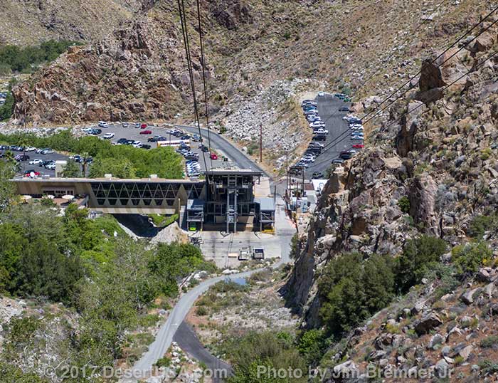
I parked, entered the large facility and walked upstairs to the ticket counter where I paid for my ticket and discovered I had about 20 minutes to wait until the next departure. So I headed for the snack bar, ordered a cup of coffee then went to the gift shop where I bought some books and pamphlets describing the tramway and its history.
In only a few minutes, the first announcement came over the PA system that boarding was beginning. This really meant that tickets were being taken, and we were allowed to enter a small waiting room with a 3-D scale model of the mountain. This allowed the operators to cut the number off at 80, but this morning, we did not fill the waiting room.
At 9:58 we boarded the car, where 50-60 of us stood together comfortably. There are no seats; we remained standing throughout the journey up the mountain. At 10:00 AM sharp, we slid from the boarding dock and began our ascent up the mountain.

O-o-o-ohs and a-a-a-ahs could be heard from some of the passengers as we moved slowly upward. As we were pulled over the first tower, the car paused briefly, rocked just a little, then moved forward and up. This thrilling vertical ascent of more than a mile offers spectacular views of the Chino Canyon and the San Jacinto Mountains from the front of the car, while the Sonoran Desert is splayed out below from the rear of the car.

I craned my neck to see to the top of Chino Canyon, and snap a few photos, then looked behind and below as we moved from one ecological zone to another, a total of five in all, from the creosote shrub of the lower desert through the Sonoran and Transition zones to the Alpine zone at the top -- all in 10 minutes.
Mountain Station
We were suddenly at the Mountain Station dock, and I walked from the car into the large, 3-story facility. The temperature was now 57 degrees. Mountain Station is huge. It contains a cocktail lounge, dining facilities, gift shops and observation areas, as well as a theater showing a 22-minute movie on the history and construction of the Palm Springs Aerial Tramway.

View from Station
Immediately behind Mountain Station is the 13,000-acre Mt. San Jacinto Wilderness State Park. It contains 54 miles of hiking trails, five primitive campgrounds and a ranger station. One can enjoy mule rides here in the summer or rent cross-country skis in winter.

Back side of Mountain Station
I headed out the back side of Mountain Station and descended the switch-backed sidewalk for 200 yards to Long Valley. To the right was the ranger station, where permits are issued to those wishing to engage in serious hiking, backpacking and camping, including the ascent to the peak of Mt. San Jacinto itself, the second highest mountain peak in southern California at 10,804 feet.
To the left, a very easy, 3/4-mile self-guided nature trail forms a loop through the Arctic -Alpine zone of firs, oaks and numerous evergreens. I pulled out my free brochure "Long Valley Discovery Trail" that I picked up inside Mountain Station, and read about the marked stops along the trail.
Desert View Trail, at 1.6 miles, is slightly more strenuous and provides two locations to view the Coachella Valley below and the Santa Rosa Mountains to the east.
After an easy jaunt along both trails, a peek inside the ranger station and a rest at one of the overlooks, I returned to Mountain Station, ordered lunch and sat on the terrace overlooking the desert below and read the items I had collected along the way. I learned the following.
Watch a video of the story
The Tram Story
Credit for conceiving the tramway project goes to Francis Crocker, manager of the California Electric Power Company, who came to Palm Springs in 1932. At that time, there were only a couple hundred people living in Palm Springs. It had one cafe, one grocery, one drug store and a small branch bank. There was no air conditioning in those days, and Crocker thought it would be wonderful to travel quickly up to the mountain where it was cool.
He said so, and kept saying so, even though, at first, most folks though the notion preposterous. But he eventually enlisted local supporters, including Earl Coffman, owner of the Desert Inn, Palm Springs' first and most famous resort hotel.
Crocker spent the next 30 years planning, financing, and building the tramway. Conservationists were initially opposed the idea, and it wasn't until 1945 that Governor Earl Warren signed a bill authorizing the project. But it was another 16 years -- when Governor Pat Brown became a supporter of the project in 1961, that bonds were issued so financing and construction could begin.
These delays of almost three decades, actually had a beneficial effect on the project. Technology had greatly improved since the time the original plans had been drawn. When construction on the first tower finally began in August, 1962, both the route and the number of towers required were changed.
Technical advances had made it possible to spin heavier track cable capable of supporting two 80-passenger cars. Other technological advances allowed the number of towers to change from 9 to 5, and meant that instead of requiring a midway transfer station, the mile ascent could be made in one sweep. This would make the tramway the longest single span lift in the world at 2.5 miles.
It also meant that in spite of increased construction costs, the 1961 costs were $3 million less than estimate from the 1940s.
Because of the wilderness designation of Long Valley at the top surrounding Mountain Station, no road construction was allowed. The only overland route, weather permitting, would be from Idyllwild, a small mountain community on the far side of Mt. San Jacinto.
Access to the initial construction site at Valley Station was no problem. A 4-mile road was built from Route 111 to the location (the same road we drove up earlier). But the movement of men and materials to the other 4 towers sites and Mountain Station itself presented a real challenge, especially since workers were given only 660 days to complete the project.
Another technological advance, the helicopter, saved the day. The tramway became one of the largest construction projects ever undertaken involving transportation of materials by helicopter. Helipads were built near each of the tower sites and made more than 23,000 flights, hauling more than 5,500 tons with average loads of 700 pounds. It was often necessary to disassemble heavy equipment which would be flown to the workplace location and reassembled.
Before it was over, approximately 600 tons of steel were used in the fabrication of the tramway cables and towers using more than 27 miles of locked-coil cable, wire rope and strand. The main four rolls of track cable came in 60 ton spools, 13,500 feet long, 1 7/8 inches in diameter. To complete installation of these cable, a giant hoist with a 100-ton capacity was flown in pieces to Mountain Station.
On October 12, 1963, the Palm Springs Aerial Tramway was officially opened with a ribbon cutting ceremony by Governor Pat Brown and a group of 50 businessmen and celebrities who paid $1,000 each to make the maiden ascent to the top.
In 1998, the Tramway announced that it was embarking on an ambitious modernization program that would see the construction and installation of new cars and an update of its facilities. Beginning in September 2000, passengers first rode the world’s largest rotating tramcars. The tramcars do not rotate, the floor inside of the tramcars slowly rotate giving the rider a 360 degree views of the canyon that leads to the station at the top.
How it Works
So here I was, sitting atop the mountain eating lunch and peering 8,500 feet below across the desert floor of the Coachella Valley. Quite an accomplishment, indeed. I heard first call for the descent back to Valley Station, but I had a little more time for reading.

The tramway is known as a double reversible type of aerial tramway. Each car remains on one pair of track cables moving up and down without turning around. Each car serves as a counter balance to the other, the descending car is helping pull the ascending car up the mountain.
The light tramway cars hold 80 people each and are suspended from a carriage that holds 24 grooved wheels which ride upon the track cables. The cars are pulled by two pairs of traveling, hauling cables, moving in idler pulleys over the tower saddles.

Power is provided by a 1,000-horsepower electric motor. The traveling hauling cables are pulled over a 9-foot diameter bull wheel located at Valley Station. Power is needed only to move the under balanced part of the load, provide acceleration and to overcome friction.
Maximum load on the power system occurs when there is an empty car coming down and a full one going up. When a more heavily loaded car is coming down, the system acts in reverse, serving as a brake.
My lunch and reading finished, I ambled over to the ticket area and entered the waiting room. In a couple minutes, the door opened and we walked out to the car and went aboard. The operator closed the door, and we started moving, gliding gracefully but rapidly downward, once again passing through the five vegetation zones, as the temperature warmed and Valley Station grew larger. About a third of the way down, the ascending car went zooming by us on its way to the top.

Back at the car and one last look at the Tramway
Before I knew it, we glided to a stop at Valley Station and were disembarking. By now, there were many more people at Valley Station making the trip to the top, and the tram was running every 15 minutes. As I was leaving the building, my car, filled with another excited group, began its ascent of the mountain. I watched as it glided out of sight up Chino Canyon, then found my car. As I drove back down Tramway Road to Palm Springs, I noticed the temperature was 96 degrees.
How to Get there
Coming from the west, you enter California's westernmost finger of the Sonoran Desert -- the Coachella Valley -- which emerges from San Gorgonio Pass between the San Jacinto Mountains to the south and the San Bernardino Mountains to the north. The pass crosses Interstate 10 about 25 miles east of the Riverside/San Bernardino area.
Palm Springs, the westernmost outpost of civilization in California's Sonoran Desert, lies just southeast another 20 miles or so, nestled against the base of the San Jacinto range. From I-10 exit at California Route 111, and after another 9 miles, take a right at Tramway Road and drive 3 1/2 miles up Chino Canyon.
This is a well-paved, fairly steep road, rising in elevation from Palm Springs (411 feet) to the Valley Station (2,643 feet). The speed limit is 25 mph, so take your time and enjoy the scenery. The creosote scrub and desert flora in the bottom of Chino Canyon provide an array of scenic views. Map - Hours of Operation
Related Books & Gifts - Trading Post
Outdoor Recreation: Hiking & Climbing
Palm Springs Desert Museum
The Living Desert Wildlife & Botanical Park
Palm Springs, California
Related DesertUSA Pages
- How to Turn Your Smartphone into a Survival Tool
- 26 Tips for Surviving in the Desert
- Death by GPS
- 7 Smartphone Apps to Improve Your Camping Experience
- Maps Parks and More
- Desert Survival Skills
- How to Keep Ice Cold in the Desert
- Desert Rocks, Minerals & Geology Index
- Preparing an Emergency Survival Kit
Share this page on Facebook:
The Desert Environment
The North American Deserts
Desert Geological Terms


