Cooke’s Canyon
Journey Of Death
By Jay W. Sharp
As W. Thornton Parker, M. D., said in his Annals of Old Fort Cummings, New Mexico, 1867-8, Cooke’s Canyon, which slices across southwestern New Mexico’s Cooke’s Range, was a “journey of death.” It ran generally east to west, “six miles or more in length, and with a gloomy gorge of four miles to add to its terrors. ...in this Canyon many an emigrant train, and travelers, and hunters, as well as soldiers of the regular army, have gone to their deaths at the hands of the cruel Apaches.”
The Most Feared Passage
In fact, the Chiricahua Apaches, under the leadership of legendary chiefs Mangas Coloradas and his son-in-law Cochise, made Cooke’s Canyon probably the most fearsome single passage on any of the trails across the desert Southwest. They invested it with a danger that likely exceeded that of Doubtful Canyon, beside the Arizona/New Mexico border; Apache Pass, in southeastern Arizona; or the El Camino Real de Tierra Adentro’s Jornada del Muerto, in south central New Mexico. Over the years, they left dozens to hundreds of dead and wounded lying along the Cooke’s Canyon trailway or battlefields, while sometimes, themselves, suffering numerous dead and wounded.

The Apaches struck in Cooke’s Canyon, as well as in other locations, of course, with the intention of preserving their wilderness home from the intruders who had come to conquer Apache lands, build unwelcome settlements, trap out the fur-bearing animals, decimate mineral-laden hillsides and streambeds, graze out the grasslands, and exterminate or drive out the Indian peoples. In the early 1860s, the Apaches must have believed that the timing was ideal. They watched as their foes, preoccupied with the Civil War, withdrew fighting men from the West and dispatched them to eastern battlefields. The Apaches knew their enemy had grown weaker. They could see that civilian populations had become more vulnerable. They believed that the time had come. Intimately familiar with their land, the Apaches knew that Cooke’s Canyon offered perfect opportunities to waylay an adversary. Although a rugged passage, it had long drawn travelers because, at its eastern end, it had Cooke’s Spring—the only water on the 70-to-80-mile stretch across the desert between the Rio Grande to the east and the Mimbres River to the west. In fact, prehistoric peoples had passed and camped by the spring over centuries, leaving ceramic and other artifacts behind. In historic times, civilian expeditions and military units followed the trail past the spring.
Two stage lines – the Butterfield and the San Antonio-San Diego mail and passenger services – maintained a way station near the spring. Further, Cooke’s Canyon offered the Apaches perfect ambush sites, with hills and cliffs overlooking the trail and boulders and brush providing concealment and protection. Even after the U. S. Army built and manned Fort Cummings near Cooke’s Spring in 1863, with the intention of protecting those who ventured through the canyon, the Apaches continued their relentless campaign. Probably many of the Apache attacks in Cooke’s Canyon went unnoted except for the bodies that travelers sometimes encountered and covered with stones along the trail. Some conflicts, however, became storied battles and do appear in the written record.
Ake Party Attack, Summer, 1861
In the summer of 1861, Mangas and Cochise discovered that an irresistible target was approaching Cooke’s Canyon from the west. Known as the Ake Party (after member Felix Grundy Ake), it included, said Edwin R. Sweeney, Mangas Coloradas, Chief of the Chiricahua Apaches, several ranchers and their families fleeing the Apache threat in southern Arizona and several people heading east from Tucson. The Ake caravan consisted of seven wagons and two buggies, several men on horses, and – most tempting to the Apaches – well over a thousand head of livestock. The Apaches, probably with some 200 warriors, set an ambush near the western end of the canyon’s narrow gorge. They watched the Ake Party approach about the middle of the morning. Drovers herded the livestock into the gorge first.
The wagons and buggies, with mounted escorts, followed. The Ake Party’s anxieties rose as one escort discovered the bodies of two men killed in an earlier Apache ambush. Still the party, evidently confident that its numbers and arms would discourage an attack, pushed on. Once the entire party had entered the gorge, the Apaches sprang their trap, unleashing, as Sweeney said, “a tremendous volley of arrows and bullets...” In the ensuring chaos, drovers took cover and returned fire. Lead wagons formed a makeshift triangular-shaped fortification, securing some refuge. Trailing wagons swiftly reversed course and fled back west, away from the ambush and toward the Mimbres River and safety. While some of the Apaches prosecuted the battle, others gathered up the Ake Party’s livestock. As the fighting wound down to a close late in the afternoon, the Apaches had killed four of their enemies and wounded a number more, and they had apparently suffered several dead and wounded of their own. They had made off, said Sweeney, with some 400 cattle and 900 sheep, planning to market many of them in the Mexican state of Chihuahua.
Oak Grove Massacre, January 17, 1866
The Apaches also turned their wrath on Fort Cummings’ troops. In the winter of 1866, they discovered a wood-cutting detail of seven soldiers at Oak Grove, about five miles northwest of the fort. According to the New Mexico Genealogist, March, 1969, Corporal Webber, in charge of the detail, commanded six privates: Ronan, Hunter, Devin and Daly, Matthews and Goldsberry. They all belonged to Company G. 1st Veteran Infantry, California Volunteers. At Oak Grove, as the Apaches found, the detail had established its camp and gone to work cutting and gathering badly needed winter firewood for the post. On January 16, Corporal Webber returned to Fort Cummings to replenish provisions for his men. The next morning several dozen Apaches attacked the Oak Grove campsite just at breakfast time, overwhelming the six privates as they rushed to pick up their arms to return fire. With bows and fire arms, the Apaches shot Ronan, Hunter, Devin and Daly, whose bodies, after the battle, they would mutilate with lances. Somehow, the Apaches let Matthews and Goldsberry escape, although one of the warriors drove an arrow into Goldsberry’s hip.
The two privates straggled back toward Fort Cummings, finally encountering Webber returning to Oak Grove with the provisions. Notified of the attack, Webber promptly alerted the post. Lieutenant John D. Slocum marshalled every available man and rushed his force to the Oak Grove encampment. As he would discover, the Apaches, having now departed, had left the four privates’ bodies, as well as one of their own, lying on the battlefield. They had looted and destroyed the campsite. That left Slocum with the sad duty of returning the four bodies to Fort Cumming, where the troops conducted formal last rites and buried the men in a single grave with a single headstone on the western side of the post cemetery. After abandoning Fort Cummings, the army would transfer the bodies of Ronan, Hunter, Devin and Daly to the National Cemetery at Fort Leavenworth, Kansas, leaving their headstone as a permanent monument to the men.
Ambush of the Freeman Thomas Mail Party, July 1861
Of all the battles in Cooke’s Canyon, there is none more famous than the Apache ambush of conductor Freeman Thomas’ westbound San Antonio & San Diego Mail Line coach in July of 1861, about two years before the Army established Fort Cummings. Although many details of the battle have been lost to history, Mangas and Cochise – watchful for travelers through the canyon – had evidently merged their forces, probably some 100 to 200 warriors at the time. They would set a trap at a point overlooking the trail about a mile beyond Cooke’s Spring, said Berndt Kühn in his excellent article “Siege in Cooke’s Canyon: The Freeman Thomas Fight of 1861,” The Journal of Arizona History. Freeman Thomas, with mail and passengers, set his coach on the westward journey from Mesilla to the Pacific coast on the morning of July 20. Always aware of a potential Apache threat, he had equipped his coach with a good supply of arms, probably including the highly effective breech-loading Sharps rifles, and ammunition. His party comprised an experienced and diverse group of men of the western frontier. Thomas himself, a 29-year-old native of Ohio, had seen the results of Apache fury first hand, on the trail. His driver, Joseph Roescher, a 26-year-old from Germany, left little clue to his past, but he apparently had worked on the stage line for some period. Thomas’ passengers – including 19-year-old Emmett Mills, Robert S. Avaline, Matthew Champion, John Wilson, and John Portell – came to the frontier from various locations to the east. They had worked as stagecoach hands, miners, ranchers and gamblers. Some had been involved in shootouts. Some had seen the aftermath of Apache attacks. They all knew the risk they faced, and they brought their own side arms and rifles.
Leaving from Mesilla, Thomas took his coach northward along the west side of the Rio Grande along the Mesilla Valley to the Picacho station, where he turned westward, past Picacho Peak, then across some 50 miles of desert to Cooke’s Spring and the eastern entrance to the canyon. There, at the spring, the party apparently rested through the night, letting the draft animals recuperate from the long and arduous haul across the desert. Come early morning, Thomas and his party renewed their journey, now beginning the passage through Cooke’s Canyon, the Journey of Death. “The stage was set,” said Kühn, “for one of the most desperate fights ever recorded in the annals of frontier warfare.” Probably, just as the coach entered the eastern end of the gorge, the Apaches opened fire, pouring a hailstorm of musket balls and arrows down onto the coach and the travelers, wounding one. Thomas swiftly put his coach in flight, westward, over the trail, with the Apaches in pursuit. Apparently fearing that more Apaches lay in wait ahead, ready to cut off any hope of escape, Thomas decided to turn off the trail, heading southward toward higher ground to take up a defensive position. Under heavy fire from the Apaches, Thomas and his men, now desperate, unhitched the draft animals and drove them down the hill, hoping that the Apaches might abandon the fight and pursue the team, according to Sweeney. That clearly failed. Swiftly, Thomas and his men stripped the coach, taking the Sharps rifles, ammunition, water and provisions. They threw up stone barricades, preparing for a siege. Seven men, one wounded, against many dozens. The Apaches continued their withering attack, but at a price. By one account, said Sweeney, they lost 25 warriors and suffered many wounded—an example of the effectiveness of the Sharps rifle in the hands of brave and experienced frontiersmen. Cochise himself and his eldest son Taza may have been among the injured. Even with their overwhelming numerical advantage, the Apaches – themselves daring fighters by any measure – evidently could not finish off Thomas and his men until sometime the following day, July 22, or maybe even July 23. In revenge for their losses, the Apaches stripped and mutilated the bodies, which were not found until two freighters passed the site several days after the fight. The ferocity of the battle, the freighters said, could be measured by the numerous shell casings littering the ground and the bullet marks covering rocks and trees around the stone barricades. According to Kühn, Cochise – who knew something about courage in battle – said that if he had 25 fighters like Thomas and his men, he would “undertake to whip the whole United States.”
Memories of Cooke’s Canyon
The violence in Cooke’s Canyon would continue for more than a decade, until the Chiricahuas’ tenacious defense of their wilderness home finally faded before superior U. S. military forces. Moreover, they had lost their legendary leaders. Mangas Coloradas, captured and imprisoned at Fort McLane, west of Cooke’s Range, was murdered on January 18, 1863, by soldiers obeying treacherous orders of Brigadier General Joseph Rodman West. Cochise, suffering from a long illness, possibly stomach cancer, died at Fort Bowie, in southeastern Arizona on June 8, 1874. With the Apache threat having abated in Cooke’s Canyon, the Army abandoned Fort Cummings in 1873, but when a new Apache leader, Victorio, resumed attacks against the invaders in the area a few years later, the Army reopened the post, in 1880. It would remain open until the Apache wars ended with the surrender of Geronimo at Skeleton Canyon in 1886, in southwestern New Mexico.
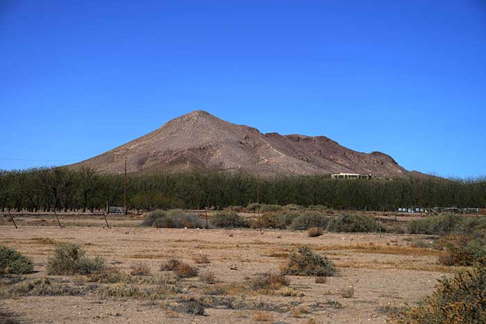
Walls of Fort Cummings, with the range and Cooke’s Peak visible on the western horizon.
While much of the violent history of Cooke’s Canyon – the Journey of Death – has been lost, fragmentary tales of conflict continued to surface over the years. “...I listened with anxiety to the stories told me by frontiers men about the dreadful massacres perpetrated by the Indians in that dread gorge,” said Parker. “It was said that even soldiers dared not stir a mile from the post, and that it was just a toss up whether any traveler got through alive.” Not long after the Freeman Thomas massacre, and near the same location, eight or nine Mexican herdsman, driving 40 head of cattle to the mining town of Pinos Altos, paused to have lunch. The Apaches surrounded and massacred them all, according to Sweeney. They were found in a pile, “horribly mutilated.” Soon after Fort Cummings was reopened, in 1880, Victorio and his Mimbres Apache warriors massacred a man named Samuel Lyons and three companions in Cooke’s Canyon, according to the rootsweb.ancestry site.
On occasion, the troops managed to turn the tables on the Apaches. In early June of 1880, said Dan L. Thrapp, The Conquest of Apacheria, “Major Morrow with four troops struck the hostiles in Cook’s [sic] Canyon, not far from Fort Cummings, killed ten and wounded three, capturing much livestock. One of the dead was said to have been the raider Washington, Victorio’s son.” In the summer of 1885, said Louie Taren in an account provided to the WPA Writers’ Project on August 12, 1938, Apaches attacked a caravan of farmers hauling produce through Cooke’s Canyon in the summer of 1884: “...the Indians attacked the ox-drawn carts. The way of traveling at the time was in two-wheeled carts with a fairly large bed to carry merchandise. The caravan was soon massacred and the complete load of merchandise was destroyed. Among those murdered was my father.”
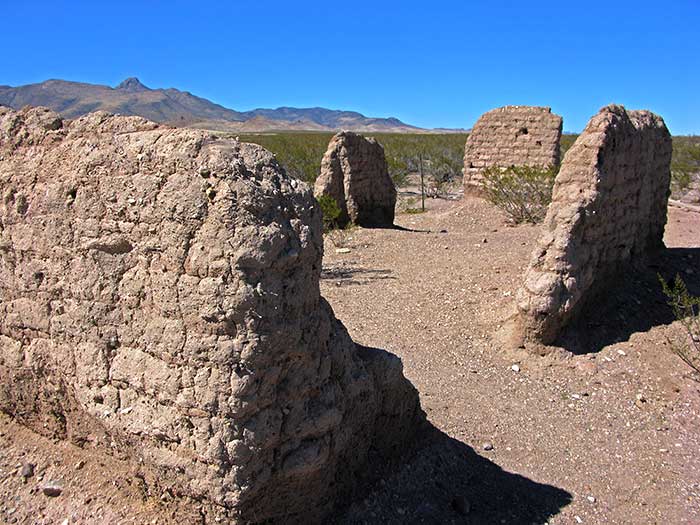
The Fort Cummings Cemetery
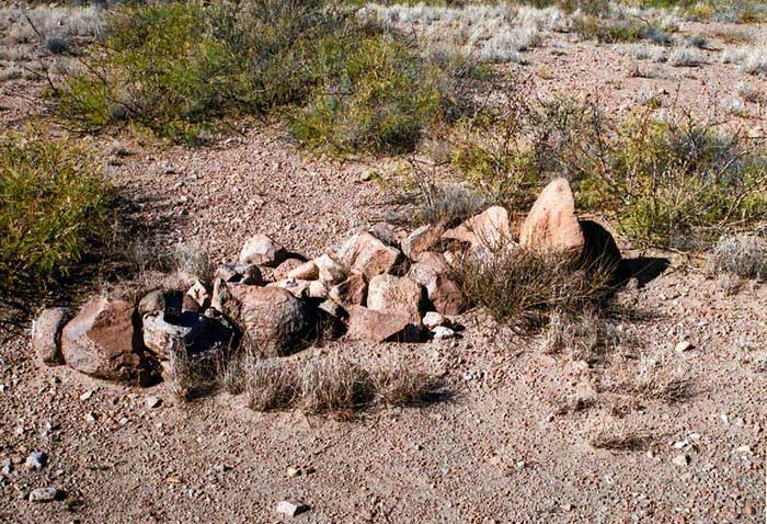
Some travelers through Cooke’s Canyon buried bodies where they found them, often covering the remains with rocks to discourage scavenging by wild animals. Some of those graves remain visible along the canyon trail today. Other travelers, who passed through the canyon after the military established Fort Cummings, reported that many exposed human skeletons lay near the trail, according to the rootsweb.ancestry site. Commanding officers dispatched soldiers to collect the remains, which they returned to the fort. They buried them, probably in a common grave, in a newly established port cemetery on a nearby ridge. Its remnants now serve as a grim reminder of the Journey of Death.
Explore Cooke’s Canyon
As I suggested in an earlier article, on Cooke’s Range, you can still follow the old trail through Cooke’s Canyon, perhaps even finding an occasional grave. On my last trip, the road was often very rough, especially near the western end of the canyon. You will certainly need a four-wheel-drive high clearance vehicle. As always in desert ventures, you should come amply supplied with water and prepared for emergencies. You should advise someone of your destination and plans. I haven’t found a really good detailed map of the Fort Cummings and Cooke’s Canyon area, but the United States Geological Survey map titled “Deming New Mexico” will serve as a basic guide. You can acquire that map, and perhaps others, at the Bureau of Land Management office in Las Cruces:
U. S. Department of the Interior Bureau of Land Management Las Cruces District Office 1800 Marquess Street Las Cruces, New Mexico 88005 Ph. 1-575-525-4300
Note: My thanks to George Hackler, who (as noted in the captions) provided several of the photographs for this article. George is the author of The Butterfield Trail in New Mexico. Although the first edition of the book is now out of print, it can be found in used book markets. It is also available as an eBook at Amazon.com.
Share this page on Facebook:
The Desert Environment
The North American Deserts
Desert Geological Terms


Click here to see current desert temperatures!