Bradshaw's Desert Trail
The Gold Road to La Paz
by Jay W. Sharp
His good friend Horace Bell called him a “most polished gentleman” and a “natural lunatic.” Whichever label fit, 36-year-old William David Bradshaw knew opportunity when he saw it. He had heard that Powell Weaver, a well-known scout and trapper, had found gold at a place called La Paz on January 12, 1862. Weaver’s strike lay on the Arizona side of the Colorado River, about 250 miles east of Los Angeles. Bradshaw figured that the inevitable stampede of Argonauts – many of them refugees from the exhausted gold mines to the north – would need a new, more direct trail east from the Los Angeles area across the desert to reach Weaver’s strike. Otherwise, they would have to travel southeast to Yuma, then north up the river to La Paz. Once the miners traveled a more direct path to reach the Colorado River, near La Paz, they would need a way to ford the stream. As a former Forty-niner, Bradshaw was well aware that a gold-strike boomtown raised business possibilities that could be more lucrative than most of the claims.
The Trail
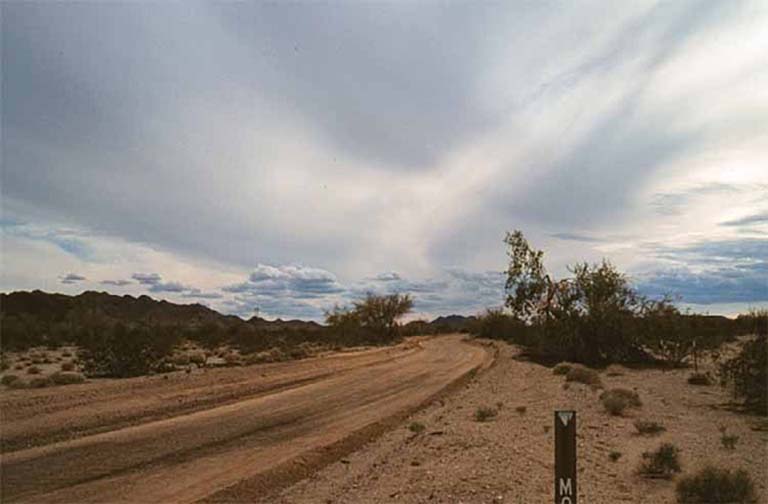
The Bradshaw Trail near Wiley's Well Campground
A charismatic, hard-drinking, generous, eccentric and physically powerful man – a natural leader on the frontier – Bradshaw recruited eight men to scout out the more direct route to La Paz. In May of 1862, he and his party struck eastward across an almost totally unknown desert area toward the Colorado River.
“On the way,” said Delmer G. Ross in his Gold Road to La Paz: An Interpretive Guide to the Bradshaw Trail, “Bradshaw was befriended by Old Cabezon, chief of the Cahuilla Indians of the Salton Sink, and a Cocomaricopa Indian mail runner from Arizona who happened to be visiting the Cahuilla villages. The two Indians provided Bradshaw with a map showing an ancient Halchidoma Indian trade route through the Colorado Desert – the northern extension of Mexico’s Sonoran Desert – complete with the location of springs and water holes.” Following the map, Bradshaw could reach the river within a matter of a few weeks.

Salton Sink, a deep desert basin (more than 200 feet below sea level) - now the Salton Sea
Beginning at San Gorgonio Pass, which lies east of Riverside, between Mount San Gorgonio and Mount San Jacinto, Bradshaw followed a 180-mile long route that first took him and his party southeastward to the northern end of the Salton Sink, a deep desert basin (more than 200 feet below sea level) alternatively fed and abandoned over the centuries by the wandering Colorado River. From the sink, the trail turned due east to the Orocopia Mountain foothills and to Dos Palmas, a “well-loved spot of desert teamsters and prospectors; the old stage station, where two springs supply an abundance of good water so that animals and men can drink all they desire without fear…” according to a later traveler quoted in Randall Henderson’s “Waterhole on the Old Bradshaw Trail,” Desert Magazine, January 1947.
Leaving Dos Palmas, the route filed eastward through the pass between the Orocopia and Chocolate mountain ranges. It skirted the southern end of the Chuckwalla range. It crossed through a gap in the Mule Mountains. From there, it descended into the welcome embrace of the Palo Verde Valley and the Colorado River. Along the way, Bradshaw and his men took refuge at water sources called Tabaseca Tanks, Chuckwalla Springs and Mule Spring. They never had to travel more than some 30 miles between water holes. Bradshaw must have felt grateful to Old Cabezon and the Cocomaricopa mail runner for their guidance. Once Bradshaw and his men reached the Colorado River, they crossed to the Arizona side, probably with the help of local Indians. They rode upstream for some four miles, to their destination, La Paz.
Bradshaw had proven out a trail that would attract miners anxious to reach La Paz and the gold fields as rapidly as possible but one that would impose the inevitable hardships of the low Sonoran Desert. Bradshaw’s road “seemed to lead to nowhere, except onward over more and more arid reaches of desert,” said the mountaineer Clarence King, who traveled the route in May 1866. “Rolling hills of crude color and low gloomy contour rose above the general level… The whole aspect of nature was dull in color, and gloomy with an all-pervading silence of death. Although the summer had not fairly opened, a torrid sun beat down with cruel severity, blinding the eye with its brilliance, and inducing a painful, slow fever… Water was only found at intervals…and, when reached, was more of an aggravation than a pleasure—bitter turbid, and scarce…” (I have drawn on Ross’ book for the quotes.)

Geological Area Nearby
What Came Next
When he and his party reached La Paz, Bradshaw evaluated his future prospects. Sensing that his new trail would attract a vigorous stream of traffic, he promptly decided that a ferry service at the Colorado River ford held more promise than a pick and shovel at an uncertain claim. (He had already tried the latter course, during his stint at California’s Sutter’s Mill gold strike in 1849.)
While promoting his new trail in Los Angeles, Bradshaw founded his enterprise at the river crossing, enlisting his brother Isaac as manager and his friend William Warringer as operations head, according to Ross. Bradshaw and his partners employed a simple raft towed by a rope that spanned the river, said Robert Stragnell in his article, “The History of La Paz,” on the Internet site E Clampus Vitus. The Bradshaw vessel could transport wagons and several draft animals. It displaced an Indian ferry service, which had employed makeshift rafts fashioned from tulle reeds. Next, Bradshaw won a 20-year exclusive franchise for his service from Arizona’s first territorial legislature, with the right to charge the following fees:
| Ferry Service | 1860s Fees |
Estimated Equivalent Today's Fees |
| One wagon & 2 draft animals |
$4.00 |
$60.00 |
| Additional team of 2 draft animals |
$1.00 |
$15.00 |
| Carriage with 1 draft animal |
$3.00 |
$45.00 |
| One beast of burden |
$1.00 |
$15.00 |
| One horse or mule with rider |
$1.00 |
$15.00 |
| One footman |
$0.50 |
$7.50 |
| Cattle & horses, per head | $0.50 |
$7.50 |
| Sheep, goat or hog per head | $0.25 | $3.75 |
Note: Ross and Stragnell provide the 1860s fees. Jim Bullock, a New Mexico State University economist, gave me the multiplier for calculating the estimated equivalent in today's fees.
Within months, Bradshaw saw the beginning of a classic boom. Gold miners, freighters, stagecoach companies and travelers from the Los Angeles area began using his new trail and, inevitably, his expensive (and monopolized) new ferry service to rush to the new gold fields. According to Stragnell, Bradshaw saw the population of La Paz swell to nearly 1500. He saw the anxious horde throw up nearly 100 brush shelters, or ramadas, including two stores and 12 saloons, and he saw them soon replace the first, flimsy structures with adobe buildings as winter approached.
Bradshaw prospered. As a driving force in the explosive growth, he became well known. He would even run for Congress, although he would lose badly because his Democratic Party held little popularity in the newly established Arizona Territory, especially during the Civil War.
Over the next few years, traffic would surge over the trail and ferry, according to Ross. Bradshaw himself had guided 150 miners over the trail in August 1862. Typically, at the peak, teamsters delivered 30 to 50 passengers plus freight to the ferry per day. Stagecoaches, often heavily overloaded, transported dozens of passengers—at $40 (equivalent now to some $600) each for a one-way fare. Travelers described Bradshaw’s roadway as “lined with teams.”
As they arrived in La Paz, the miners swarmed over the surrounding hills and washes, burrowing into the earth like a colony of prairie dogs. “It is said that at one time there were more than 5000 people working the placers of La Paz,” according to Stragnell. The community soon grew to encompass 270 city blocks. The miners, Ross suggests, recovered at least 1.3 million ounces of gold, most of it consisting of “particles ranging in size from tiny flakes to small nuggets, washed down over the centuries from nearby hills and mountains.” At some $370 per ounce – the price the ore would command in the autumn of 2003 – the total value of the gold from the La Paz mines would equal nearly half a billion dollars.
With the miners came the usual camp followers – the girls, gamblers, shysters and thieves – who meant to separate the hard working men from their hard-won gold. With the miners, too, came honest entrepreneurs – for instance, Mike Goldwater, grandfather of former Republican senator and presidential candidate Barry Goldwater – who came to sell merchandise and offer legitimate services to the booming community.
By 1870, the army of miners had already gleaned most of the gold-bearing ore from the soil and stone of La Paz. They began to leave, some with gold in their pockets, others with nothing but desert sand, to pursue new dreams. The camp followers had to find new prey; the entrepreneurs, new markets. The Bradshaw trail and La Paz withered almost as rapidly as they had blossomed. On April 2, 1870, Herman Christian Ehrenberg, a pioneer who gave his name to the community which grew up on the Arizona side of Bradshaw’s ferry, wrote a letter saying, “La Paz, at this time presents a very dilapidated appearance, and to one who saw it, some years ago…it cannot but produce feelings of sadness for it is now quite apparent that it must soon pass into ruins and become one of the things of the past.” (The quote appears in Stragnell’s article.)

La Paz was already a ghost town in the 1890s
As it turned out, Bradshaw would never see the end of the story of his trail and the gold mines. Early in December of 1864, evidently tormented after a night of heavy drinking, he turned up dead in La Paz. According to a quote taken from the Los Angeles Tri-Weekly News and published in an article, “The Bradshaw Trail,” Arizona Outdoorsman Internet site, 2001, Bradshaw “walked deliberately into a carpenters shop, took up a drawing knife, and with one stroke nearly severed his head from his shoulders.”
Travelers’ Notebooks
The crucible of a frontier gold mining boomtown, especially in the desert, produced larger-than-life characters who bore the hardships and chanced the demons of a raucous and ephemeral community in return for the opportunity to get rich quick.
A more curious or marked character this chronicler never knew; one of natures most polished gentlemen and brightest jewel in America’s collection of true born chivalry. Bradshaw was brave, generous, and eccentric; in manly form and physical beauty, perfect; in muscular strength, a giant; in fleetness of foot and endurance, unequaled.
From Horace Bell’s description of Bradshaw, quoted in
Robert Stragnell’s “The History of La Paz,” E Clampus Vitus Internet site
The very plants, scorched to a crisp, were ready, at the first blast of a sirocco, to be whirled away and ground to dust. Certain bare zones lay swept clean of the last dry stems…marking the track of whirlwinds…
We had but one canteen of…precious elixir left; the elixir in this case being composed of one part pure water, one part sand, one part alum, one part saleratus, with liberal traces of Colorado mud, representing a very disgusting taste...
After straining over…miles of silent desert, hearing no sound but the shoes of our mules grating upon the hot sand, after the white glare, and that fever-thirst which comes from drinking alkali-water, it was a deep pleasure to lie under the palms [at Dos Palmas] and look up at their slow-moving green fans, and hear in those shaded recesses the mild, sweet twittering of our traveler-friends, the birds…”
From Clarence King’s description of the Bradshaw Trail, quoted in
Delmer G. Ross’s Gold Road to La Paz
The population [of La Paz] is the worst mixture…from all parts of the earth, that I ever saw.
From an Alta California article, October 14, 1863, quoted in
Robert Stragnell’s “The History of La Paz,” E Clampus Vitus Internet site
…comely and vigorous [Mojave] women, did housework and met the domestic needs of the camp.
From commentary quoted in
Robert Stragnell’s “The History of La Paz,” E Clampus Vitus Internet site
The most potent character who ever came to Arizona was John Barleycorn. Came early and long survived and few were the men of that early day upon whom he did not set his mark. It is not strange that men drank and gambled almost universally in that time, for human existence was as arid as surrounding nature, and it was far more pleasant and practicable to irrigate the human system with alcohol than to bring water to the land
From commentary quoted in
Robert Stragnell’s “The History of La Paz,” E Clampus Vitus Internet site
A Roman Catholic Bishop visited La Paz… His presence created quite a flutter among the Mexican population, if not a revival of religion…”
From an Arizona Miner article, August 7, 1869, quoted in
Robert Stragnell’s “The History of La Paz,” E Clampus Vitus Internet site

The Trail Today
You can still follow about 70 miles of the Bradshaw Trail. The segment lies primarily on Bureau of Land Management land, running from today’s Salton Sea State Recreation Area (near Dos Palmas) eastward to today’s Wiley’s Well Campground (near the Mule Mountains). Although California’s Riverside County Transportation Department grades the route on occasion, you will still need a four-wheel-drive vehicle to negotiate stretches of soft desert sand.
According to instructions posted by the BLM Palm Springs-South Coast Field Office on its Internet site, you can reach the western end of the trail from Indio, California, by driving State Highway 111 east for about 23 miles to the recreation area. When you reach the park headquarters, turn left, on Parkside Drive, for 1.7 miles. Turn left on Desert Aire for about 0.5 miles to the Coachella Canal road. Follow the canal road for some 10 miles to Drop 24, where you will turn eastward on to the trail. You can reach the eastern end of the trail from Blythe, California, by driving Interstate 10 west for some 17 miles to the Wiley’s Well exit. Follow Wiley’s Well Road south for nine miles, just past the Wiley’s Well Campground, where you will find the Bradshaw Trail intersection. You can camp in some areas along the trail within 300 feet of the roadway, although there are no facilities.
Mindful of the harsh conditions of the area, the BLM cautions travelers: “Summers can be extremely hot. Carry plenty of water and extra food. IF you are stranded, stay with your vehicle. Always tell someone your plans, and stick to your itinerary. Further, the BLM says, “The Chocolate Mountain Aerial Gunnery Range borders a part of the Bradshaw Trail to the south. This is a live bombing range and posted as closed to public entry. DO NOT ENTER THE BOMBING RANGE.”
In his book Gold Road to La Paz: An Interpretive Guide to the Bradshaw Trail, Delmer G. Ross has put together the most comprehensive single source of information I have found about the trail route, the history, the character, the sites, side trips and travel conditions. You can acquire Ross’ book at DesertUSA’s Trading Post. Click here for more information.

Side Trips Near the Trail

Road to the Hauser Geode Beds
Hauser Geode Beds near Blythe, CA
Along the trail there are many geologically rich areas where geodes can be found. Gold Road to La Paz: An Interpretive Guide to the Bradshaw Trail contains information about conditions on the trail 25 years ago and describes locations that rockhounds may find of interest.

Geodes found in the area
Tucked deep into the Mule Mountains not far from Palo Verde lies Opal Hill Mine.
Lodging
There are hotels and motels in Blyth, CA with something for every taste and price range.
Camping
Wiley's Well Campground, a BLM facility, is located just north of the Bradshaw Trail at its intersection with Wiley's Well Road. The campground has individual campsites with picnic tables, shade ramadas and grills, but potable water is not supplied. Handicapped accessible restrooms are available in the campground. a fee is charged for overnight use.
Coon Hollow Campground, also a BLM facility, is located about three miles south of the Bradshaw Trail on Wiley's Well Road. A fee is required for overnight use. Facilities at this campground are the same as those at Wiley's Well.
More Trails
Desert Trails
Trails of the Native Americans
Coronado Expedition from Compostela to Cibola
Coronado Expedition from Cibola to Quivira then Home
Chihuahua Trail
Chihuahua Trail 2
The Juan Bautista De Anza Trail
Jornada del Muerto Trail
Santa Fe Trail
The Long Walk Trail of the Navajos
The Desert Route to California
A Soldier's View of the Trails Part 1
A Soldier's View of the Trails Part 2


Share this page on Facebook:
The Desert Environment
The North American Deserts
Desert Geological Terms


