Hiking White Canyon Country Utah
Hiking Tips
Text and Photos by Tom Klein

The troubles with hiking in the deserts of the Southwest are numerous. There's the heat, of course, the lack of water, the poisonous animals, the thorny plants, the treacherous terrain. Other than that, it isn’t bad.
On the plus side, there's stunning scenery. For me, it's the grand panorama of open country or a close look at a cloistered columbine flower in the arid canyonlands of southern Utah that keep taking my breath away. I've been coming back here to hike the canyons for years.
If you hike up a canyon, there are two drawbacks you usually have to face: the burden of a heavy backpack for extended trips and the redundancy of the return trip down the canyon. During my last trip here, I decided that I would not only enjoy the scenery and adventure, I would do something about weight and repetitiveness.
Once I met two fellows on California’s spectacular John Muir Trail who had started out with loads of as much as 120 pounds each. To this day, I have no idea how they managed to hike with such a load. Two years ago, I encountered the opposite extreme on the rugged Colorado Trail. Two young lads ambled casually along the 480-mile trail in sneakers and little more than day packs on their backs. They were hauling no more 30 pounds on their way from Denver to Durango. I immediately decided that I wanted to give this mode of travel a try. I never even considered the 120-pound gorilla option.
I began by leaving progressively more items out of my pack over the course of several trips. I finally whittled my gear to bare essentials for a trip of several days, reducing the weight of my basic pack from 50 or 60 pounds down to 30 pounds. Depending on the demands of a particular hike, water can add as much as 20 pounds even to the reduced load. I felt comfortable that I had solved the problem of weight.
The perfect remedy to the second problem – redundant return trips – emerged when I came across Steve Allen’s canyon hiking, or "canyoneering," guide books. In the vast majority of desert country hiking books, a recommended hike takes you up a canyon to seek out marvels and choice spots, and it brings you right back down again, the same way you had come.
In years of exploration throughout southern Utah, Steve Allen developed "loop" hikes that take you up one canyon and down another, connecting them via a cattle trail, slickrock buttress, rocky chute, an old mining track or some other pathway. On Allen’s journeys, a hiker gets intimately familiar with the canyon floor and with the canyon rims, or benches. This makes for a wonderful juxtaposition of narrow canyons and open sky. Allen’s hikes can be very challenging, so it is imperative to pay close attention to every detail in his trip descriptions. For backpackers experienced with reading maps and negotiating difficult terrain, these loops are a wonderful and safe alternative to traditional canyon hiking.
White Canyon
White Canyon runs through Utah’s Natural Bridges National Monument, draining a vast area southwest of the Bears Ears in a generally westerly direction. It empties into Lake Powell near Hite Marina. The White Canyon loop hike connects two major side canyons, Long and Gravel, which are separated by the prominent landmark known as Jacob’s Chair. The trail ranges from 3800 feet to 7500 feet in elevation, exiting via Gravel Canyon. It leads the hiker through a vast diversity in the geology and climate zones which contribute so much to southern Utah’s uniqueness.
I parked my car at the White Canyon trail head one sunny morning and took off. The first couple of miles are the only part of the loop which lies within White Canyon proper. The walking is as scenic as it is easy. Impressive stream bed "meanders" guide the way as the highway noise drones above on Utah 95, the Bicentennial Highway, which parallels White Canyon along its length. A brief digression up Short Canyon takes you to Indian rock art. The canyon ends at a waterfall. Digression is one of Steve Allen’s trademarks. He invites a canyoneer up many a side canyon to visit spots of special beauty, archaeological or geological significance, or rock climbing challenge, and he often covers historical tidbits, enriching the experience. After backtracking to the confluence of White and Long Canyons, I began my real hike, leaving White Canyon behind and heading north, up Long Canyon.
Long Canyon
Very quickly, Long Canyon leads to a waterfall (a misnomer since no water is actually flowing). You circumvent the fall by an old cattle trail, a testament to the time when cattle ranching was the big – in fact, the only – business in the region. Further up, the hiking becomes quite varied, even tricky at times. Fortunately, much of the customary stream bed mud had dried up, giving me good traction. Still, major water holes were full, more than waist deep. They couldn't simply be waded without soaking my backpack.
Surprisingly, keeping gear dry in the desert can sometimes be a challenge, and people have developed several different solutions to the problem. I used a rafting-type dry sack big enough to hold my entire pack. When closed, it floated and it kept my stuff dry as a bone. If needed, I could put the contraption on my back since it had regular shoulder straps like any other rucksack. Within ten minutes, I had put the water holes behind me, stowed the dry sack, and I was on my way again.
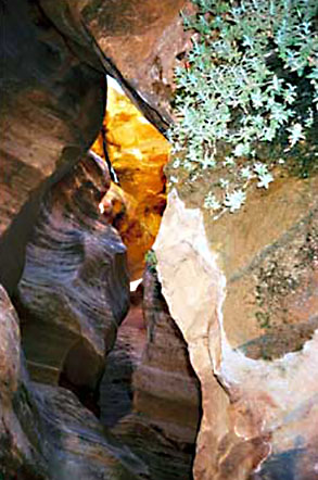
Venturing up a side canyon, I scared up an owl, or more precisely, the owl scared me up as it swooped from a crevice just above my head. Another quarter mile, and the canyon tightened up to a very narrow passage, or "slot," before abruptly terminating at another "waterfall." The curved shapes of the tortured slick rock all around me spoke to the occasional rush of water and of its creative yet destructive powers.

I discover wet maps, a damp sweater and a soaked sleeping bag. I spread my gear over the warm slick rock to dry, which took all of 45 minutes.
Late in the day, I reached a 10-foot high waterfall slot. The water in the pond at the foot of the fall was shoulder deep. I had to find a bypass. I neglected to dry-sack my pack, and as I climbed past the waterfall, I managed to pull my pack into the water by accidentally tugging too much on a hauling line I had attached to my waist. Quickly, I gained the safe and dry high ground, and I pulled up my pack. Although some of my gear got wet, it could have been a lot worse. Everything could have gotten drenched. Since it was late in the afternoon, I decided to make camp right there and dry out.
I discovered wet maps, a damp sweater and a soaked sleeping bag. I spread my gear over the warm slick rock to dry, which took all of 45 minutes. I settled in for the night.
In keeping with my "travel light" philosophy, I had not included a stove or fuel in my pack. For the six days I would be on the trail, I had brought a mere six pemican bars, a big bag of gorp, and half a dozen string cheeses. That was it. I figured that I would eat only around 1000 calories per day—a starvation diet, especially when combined with long hours of hiking in difficult terrain. I figured that a lack of food in the stomach was a small price to pay for the benefit of a small and lightweight pack. I knew from past experience that an empty belly does not diminish my performance, at least not on a trip of six days or less. Dinner was going to be short and sweet.
The night was comfortable. I slept well. Early next morning, I crammed the therma-rest and sleeping bag back into my pack and a pemican bar into my mouth. I was ready to go.
The day before, I had made it up Long Canyon almost all the way to where the route exits onto the rim. But before going up and out today, I explored the rest of the canyon until it ended at a couple of verdant springs near a plunge pool below a high vertical waterfall. This formidable red rock country always has little surprises in store like this refreshing alcove.
I washed up in one of the springs and poured a gallon of water into my "dromedary," a water bag that holds up to 2.5 gallons. So far, I had enjoyed cold, clear and pure water from little holes all through Long Canyon. I hadn't had to carry more than one quart of water at any time. The next stretch, however, from Long Canyon to Gravel Canyon, was going to be hot and dry. I planned to carry all the water I would need for a full day of solitary hiking.
I didn't anticipate encountering another soul. So far, I hadn't seen a recent human foot print. Allen’s hikes are rarely truly remote, but they seem to be little visited. I relished the solitude.

The Neck
I climbed up and out of the canyon floor seemingly traveling in the wrong direction. Following the route’s loops, I gained the rim, and as I traversed the Cedar Mesa slickrock, I finally turned into the right direction, to the east. Jacob’s Chair dominated the landscape, and the higher I got, the more the red rock formations revealed themselves. The Henry Mountains and the Little Rockies loomed in the far distance. I scrambled up the Organ Shale and climbed through a thin layer of White Rim Sandstone to get on top of an exposed prow. I took a break, nibbled on some gorp and relished the magnificent views.
Above the prow, I joined a very rough four-wheel drive vehicle track which grew into a jeep road. It took me to The Neck, the narrow watershed between Lost and Dark Canyons to the north and Gravel Canyon to the south. The sun and bright blue sky were beginning to have an impact. Up here, it was significantly warmer and windier than down in the canyon. I applied sunscreen, and I chugged water. The guide book sent me down a boulder-choked gully to the benches that contain the uppermost reaches of the Gravel Canyon drainage.
The challenge now was to find the correct route into the head of Gravel Canyon. As I traversed the pinyon- and juniper-covered plain I came across a prehistoric Indian village midden, or trash heap, which had scores of centuries-old pot shards. I had a hard time envisioning pre-Columbian life in the southern Utah canyonlands. I moved on.
I dropped into a prominent drainage, but a precipitous escarpment convinced me that this was not where I wanted to be. Re-scaling the rim, I located the actual head of Gravel Canyon a little further east, but I was above vertical cliffs which I didn't want to climb down. Following the canyon’s west rim to the north for a mile, I eventually found a decent route. I descended safely to the canyon floor.
Gravel Canyon
 The head of Gravel was as dry as powder. I listened happily to the good water sloshing in the bag on my back. Another hour down the dry bottom and I put up camp on a sand bar at a minor confluence. Given the weather of the last days and my location near the beginning of the drainage, I felt quite safe from any flash flood. A restful night under a vast starlit canopy was a wonderful reward for a long and hard day on the trail. The constellation Cassiopeia’s course through the dark sky gave me a measure of the passage of time as I woke up occasionally.
After a "big" breakfast containing all three of my food groups, I resumed the hike down Gravel Canyon, exploring a couple of side canyons with their slots, water holes and distinctive desert flora. In the main canyon, I wound through boulder-strewn bottle necks. Awesome narrows were confined by unscalable walls and paved with soft, smooth gravel. At last, water holes reappeared, containing delicious and perfectly clear water. I drank the water straight from the source, untreated and unpurified. It is a calculated act of defiance of the conventional backcountry wisdom to treat or boil all drinking water. Luckily, as it turns out, I suffered no ailments from giardia or other water-borne contaminants.
Late in the afternoon, I arrived at Gravel’s last major confluence, and I selected a campsite high up on a ledge which led to a side canyon I would explore the following morning. Mosquitoes buzzed around my ears all night. I regretted not having brought a tent. I slept miserably, incredulous that there were any bugs at all in this arid location.
As the sun rose, I tried to figure out whether I had slept five minutes or five hours. Once I began to explore the side canyon early next morning, however, I forgot the mosquitoes. Great narrows, delicious spring water and a side slot captured my attention and fascination. I called one passage "The Gates of Eden" because of its lush vegetation and vertical symmetry. I continued down Gravel Canyon, at times walking on the canyon floor, at times avoiding treacherous sections by staying up on the benches.
The ruins of a prehistoric village up on a ledge added excitement to my trip. I explored the remnants of ancient cultures, taking care not to disturb the structures or the artifacts. I admired the daring, craftsmanship and resourcefulness of those who made a living in this unforgiving country many centuries ago.
In late morning, I reached the first of several "rappels," as the guide book calls them. With the right equipment, groups can descend down a steep wall here, then complete a second rappel and continue on down Gravel Canyon. Since I did not bring any rappelling gear, I followed the book’s instructions to exit Gravel Canyon by scaling a section of steep slick rock that tops out at the rim, a challenge which I enjoyed. I traversed the expansive bench lands between Gravel Canyon and Jacob’s Chair.
It was hot in the open. I came to Cowboy Canyon, a tributary to Gravel Canyon. It cut straight across my path. To cross, I climbed down at the earliest opportunity, proceeded up the canyon and soon found an easy way up the other side. Back on the benches, I followed a cattle trail west as I passed below mighty Jacob’s Chair.
The guide book mentions a long narrow pool at the very end of Gravel Canyon, and so I tried to re-enter that canyon below the second rappel by descending down a side canyon. Unfortunately, the drop-offs were too severe and the topography too unforgiving for me to proceed. I regained the benches and resumed plodding along the cattle trail. It eventually turned into a rough road that after another hour or so finally took me back to my car.
My feet were hot. My mouth was parched. I was tired and happy. I drove ten miles to the store at Hite Marina. A little later, I quenched my thirst with a progression of iced water, iced coke and iced beer. I cooled my heels in the waters of Lake Powell. I let a few days pass by, and I began to look ahead to a weekend in nearby Bluff, where they would play bluegrass music at the annual festival on Sand Island, on the banks of the San Juan River.
Epilogue
According to Steve Allen, the hike I had just completed should take a group of strong canyoneers six days, maybe as much as eight, especially if they explore the side canyons. I completed the hike, canyons and all, in four days, primarily because I hiked solo, I have rock climbing experience, and I carried a light backpack. I carried only the most essential gear, for instance, a first aid kit, rain gear and long johns in addition to the items I mentioned. This small load allowed me to maintain a very steady pace. Moreover, I did not have to back track down a canyon I had already explored.
The way I look at it, southern Utah’s canyon country has so much to offer that I can put conventional creature comforts and nutritional requirements on the back burner for a few days every once in a while.
Technical Information
You will find everything you need to know, including whether this kind of hike is for you, in Steve Allen’s Canyoneering 2 - Technical Loop Hikes In Southern Utah, University of Utah Press, Salt Lake City, Utah, 1995. He also has written Canyoneering and Canyoneering 3.
NOTE: DESERTUSA RECOMMENDS YOU ALWAYS PURIFY YOUR WATER BEFORE YOU DRINK FROM ANY STREAM OR SPRING.
Related DesertUSA Pages
Desert Hiking & Climbing Trails
Related DesertUSA Pages
- How to Turn Your Smartphone into a Survival Tool
- 26 Tips for Surviving in the Desert
- Death by GPS
- 7 Smartphone Apps to Improve Your Camping Experience
- Maps Parks and More
- Desert Survival Skills
- How to Keep Ice Cold in the Desert
- Desert Rocks, Minerals & Geology Index
- Preparing an Emergency Survival Kit
Share this page on Facebook:
The Desert Environment
The North American Deserts
Desert Geological Terms


