Death Valley National Park
Auto Tour West: California Route 190
Overview | Map | Description | Things
To Do| Camping/Lodging | Nearby
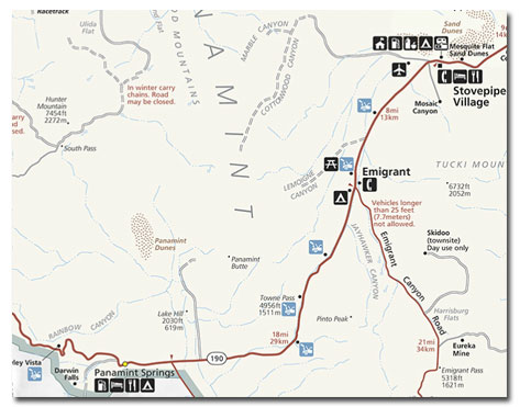
California Route 190 runs east from U.S. 395 at Olancha, California (about 100 miles from Furnace Creek Visitor Center), over Towne's Pass (4956 feet) into Death Valley National Park.
As the first auto route into Death Valley in 1926, it was called the Eichbaum Toll Road. It is relatively steep on both sides of Towne's Pass, but it is the faster, if less interesting, entrance from the west.
About 65 miles from the turnoff, 190 merges with California Route 178 north of Emigrant Canyon. From here, it is about 6 miles to Mosaic Canyon turnoff on the east.
This dirt road leads up a wide alluvial fan to the mouth of the canyon from which there is a sweeping view of the northern part of Death Valley. A short walk into the canyon reveals walls of polished, multi-colored rock, best seen about noon.
Another 2 miles further on Route 190 brings you to Stovepipe Wells Village, a small town where all services are offered. From here, the highway turns east. Five miles further is the Devil's Cornfield off to the south. Because of erosion, Arrowweed Bushes in this area grow in individual, strange-looking clumps, resembling shocks of corn. Native Americans used the plants to fashion arrows shafts.

Another 2 miles further along, you will probably notice vehicles parked along the highway. From here it is only a short 1/4-mile walk to the Sand Dunes to the north. Sand covers 14 square miles of Death Valley here. Wind continually ripples and rearranges these dunes, but mountain barriers maintain the main contours of the dunes from year to year and prevent them from moving cross-country.
From here, Route 190 turns south, and it is only 20 miles to the Furnace Creek Visitor Center.
| Southeast: California Route 178 |
| East: California Route 190 |
| Northeast: Nevada Route 374 |
| North: Nevada Route 267 |
| West: California Route 190 |
| Southwest: California Route 178 |
Overview | Map | Description | Things
To Do| Camping/Lodging | Nearby
Share this page on Facebook:
The Desert Environment
The North American Deserts
Desert Geological Terms
SEARCH THIS SITE

Ballarat, and the Rainbow Chasers
Ballarat, California.At the end of every rainbow is a pot of gold. Parked at the base of the Panamint Mountains are the remains of Ballarat, California. Founded in 1876 as a supply center for gold mines and prospectors, Ballarat lasted 21 years.
Death Valley - Overview
Take the Death Valley grand tour - see the Badwater Basin, the lowest place in North America; the dramatically eroded Sabriski Point; Artist’s Palette, with its unusual tonal colors; Salt Creek and its pupfish, Titus Canyon and more! See why Death Valley is such a spectacular National Park!
Death Valley - Scotty’s Castle
Find out how Scotty's Castle came to be, when Albert Johnson met Walter Scott, later known as Death Valley Scotty. Take a tour of the magnificent rooms and see the castle's fantastic furnishings. Hear the organ in the music room as you experience this place of legend first-hand.
Titus Canyon, drive through Red Pass
As Titus Canyon Road in Death Valley reaches the foothills, it starts to climb and meander among the sagebrush and red rock outcroppings. The road becomes steeper and narrower as it approaches Red Pass, amply named for its red rocks and dirt. Enjoy the ride!


Click here to see current desert temperatures!
DesertUSA is a comprehensive resource about the North American deserts and Southwest destinations. Learn about desert biomes while you discover how desert plants and animals learn to adapt to the harsh desert environment. Find travel information about national parks, state parks, BLM land, and Southwest cities and towns located in or near the desert regions of the United States. Access maps and information about the Sonoran Desert, Mojave Desert, Great Basin Desert, and Chihuahuan Desert.