Paul:
There is a very thin gray line between fact and fiction involving history. Some claim history is always written by the conquerers. This is also very true with lost treasure and lost gold mines. There are so many different version to every story and many of the versions are just the imagination of some and the vision of others. I prefer objective scientific methodology when trying to solve a problem and even a puzzle. Yes, Paul, I don't know why anyone wouldn't have mention crossing the Salt River. The river was an year-aroung source of water in those days control by a regulated flow from Roosevelt Dam to Granite Reef Dam. I am sure you can check the flow records at Salt River Project for the years 1920-1925. I doubt they river was ever absolutely dry in those years unless there was a major drought.
Take care,
Tom K.
Superstition Mountain History Discussion - OLD B/W PHOTOS
Moderator: somehiker
-
Jim Hatt
Re: Superstition Mountain History Discussion - OLD B/W PHOTO
Tom,
Do you know of any crossing places where the water was shallow back in those days? Al Reser told me that Mickey Plemens used to ride back and forth across the Salt when he worked at the Tortilla ranch.
Best,
Jim
Do you know of any crossing places where the water was shallow back in those days? Al Reser told me that Mickey Plemens used to ride back and forth across the Salt when he worked at the Tortilla ranch.
Best,
Jim
-
LDMGOLD
- Posts: 440
- Joined: Mon Jul 06, 2009 9:30 am
- anti-spam detector: No
- The middle number please (4): 4
Re: Superstition Mountain History Discussion - OLD B/W PHOTO
Jim:
Prior to the building of Mormon Flat Dam 1925, Horse Mesa Dam 1927, and Stewart Mountain Dam 1930. the Salt River could be crossed in several locations. When Mormon Flat Dam was completed in 1925, there were only three main crossings that were safe and that depended on water demand from the Salt River Valley and spring runoff. The crossing Mickey probably used was the old Crabtree crossing, or maybe the Davis Wash crossing. There was another crossing below McKay's Camp near Burnt Corral. After 1930, your horse either swam or floated across on a barge unless the lake was drained. Al Reser was always looking for a spot where the soldiers crossed the Salt River. He and I talked about it for hours on different occasions. He spent a lot of time here at the house in the early days talking about what he Clay were doing. Of course the great schism Monte and Al came when Monte Edwards found out Clay and Al Reser where partners and working an area in Tortilla Creek. Monte hiked up Rye Creek and crossed over the divide into Tortilla Creek and spotted Clay and Al in a camp. He was convinced Al had betrayed him and that was the end of their partnership. I happen to have both sides of that story on tape. There is a lot of interesting intrigue when it comes to all these old time Dutch Hunter trying to filter clues from each other. I am sure you probably heard a completely different story, but at least mine dates back at least thirty-five years ago.
Take care.....Tom K.
-
Jim Hatt
Re: Superstition Mountain History Discussion - OLD B/W PHOTO
Morning Tom,
Thank you for the info about river crossings in the old days. I know Al was very interested in a location North of the river. Mickey Plemens (according to Al) found an area up there where there were a number of very old mines. He promised to take Al to them, if Al would put up the money, and file mining claims in both their names. Unfortunately Mickey died sudden and unexpectedly before that ever happened.
Yes I heard about the split between Monty and Al from both Al and Clay, and as you said... Each has his own side of the story. Even the area where the event took place, varied from one story to the other.
It was a bitter split between the two of them (even tho they had been very close friends for a long time).
It clearly demonstrates what I have been trying to get across to the newer generation of Dutch-Hunters, about moving freely between one camp and another, trying to be friends with everyone, and glean everything possible from all the different camps.
In the end, they end up being loyal to, or trusted by nobody, and are never taken into anyone's confidence. By the time they learn that, it is usually too late, because once they are tagged as "Freelance Wildcats", they can never shake it off, and be accepted into any recognized and established camp.
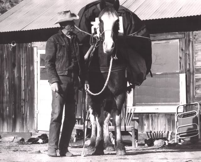
Photo of Mickey Plemens in front of the old Tortilla Ranch House.
Taken by: Al Reser (Early 1960's if I remember correctly)
Thank you for the info about river crossings in the old days. I know Al was very interested in a location North of the river. Mickey Plemens (according to Al) found an area up there where there were a number of very old mines. He promised to take Al to them, if Al would put up the money, and file mining claims in both their names. Unfortunately Mickey died sudden and unexpectedly before that ever happened.
Yes I heard about the split between Monty and Al from both Al and Clay, and as you said... Each has his own side of the story. Even the area where the event took place, varied from one story to the other.
It was a bitter split between the two of them (even tho they had been very close friends for a long time).
It clearly demonstrates what I have been trying to get across to the newer generation of Dutch-Hunters, about moving freely between one camp and another, trying to be friends with everyone, and glean everything possible from all the different camps.
In the end, they end up being loyal to, or trusted by nobody, and are never taken into anyone's confidence. By the time they learn that, it is usually too late, because once they are tagged as "Freelance Wildcats", they can never shake it off, and be accepted into any recognized and established camp.
Photo of Mickey Plemens in front of the old Tortilla Ranch House.
Taken by: Al Reser (Early 1960's if I remember correctly)
-
LDMGOLD
- Posts: 440
- Joined: Mon Jul 06, 2009 9:30 am
- anti-spam detector: No
- The middle number please (4): 4
Re: Superstition Mountain History Discussion - OLD B/W PHOTO
JIM:
Al also gave me a copy of that photo and a couple others that included Stoney in them. Nyle Leatham took some great photos in 1948 and gave me several copies of them when they were all working round up on Tortilla. Probably I should do a column on old Mickey one of these days. But there are some stories about old Mickey that are better not told.
Tom K.
-
Jim Hatt
Re: Superstition Mountain History Discussion - OLD B/W PHOTO
LDMGOLD wrote: I Probably I should do a column on old Mickey one of these days. But there are some stories about old Mickey that are better not told.
Tom K.
Tom,
Truth be told... There are stories about me (and you) and just about every other Dutch-Hunter I have ever known, that are better not told...
Would you not agree?
So what makes Mickey any different from the rest of us?
Best,
Jim
-
roc2rol

- Posts: 825
- Joined: Thu Feb 04, 2010 8:58 pm
- anti-spam detector: No
- The middle number please (4): 4
- Location: Dutch's Ditch, AZ
Re: Superstition Mountain History Discussion - OLD B/W PHOTO
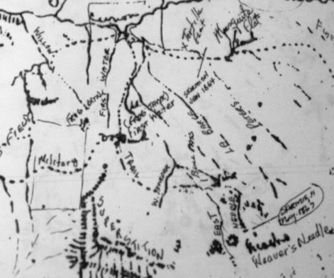
Hi Tom & AllLDMGOLD wrote:While we are on area maps. Here is an 1868 map of the Superstition Mountain area. Note Weaver's Needle is called Picacho. A few names were added to the map to distinguish some of the various locations. have fun with it.
Tom K
Excellent thread & information!
Regarding this unique map.
Would you know if the 'Superstition' designation
is an orginal writing or added later?
Thanks so much
Ed
-
LDMGOLD
- Posts: 440
- Joined: Mon Jul 06, 2009 9:30 am
- anti-spam detector: No
- The middle number please (4): 4
Re: Superstition Mountain History Discussion - OLD B/W PHOTO
The word "Superstition" was added at a later date just to show where the mountains were on the map. The map was an original military sketch map done and turned in with a campaign report at Fort McDowell by a field officer in or around 1868. Several of the terms on the maps were added at a later date.
Tom K.
Tom K.
-
roc2rol
- Posts: 825
- Joined: Thu Feb 04, 2010 8:58 pm
- anti-spam detector: No
- The middle number please (4): 4
- Location: Dutch's Ditch, AZ
Re: Superstition Mountain History Discussion - OLD B/W PHOTO
Thanks Tom!
In my studies I’ve been trying to discover when the Superstition Mountains were first cited in print.
That seems like an answer that should be fairly well known.
How & When the Superstition acquired that name seems to be bit more of mystery.
Ed
In my studies I’ve been trying to discover when the Superstition Mountains were first cited in print.
That seems like an answer that should be fairly well known.
How & When the Superstition acquired that name seems to be bit more of mystery.
Ed
-
LDMGOLD
- Posts: 440
- Joined: Mon Jul 06, 2009 9:30 am
- anti-spam detector: No
- The middle number please (4): 4
Re: Superstition Mountain History Discussion - OLD B/W PHOTO
Ed:
The first time that the word Superstition was applied to the Superstition Mountains was probably around 1866. The military made several reference to the mountain in their campaign reports as Sierra Supersticiones. Actually most references at the time called the mountains the Salt River Mountains. The first published maps that made clear reference to these mountains as the Superstitions was about 1870. All these maps references can be found in the Hayden Library, Map Section, at Arizona State University. I researched this topic at Hayden Library when I was taking a cartography class for my geology degree a long, long time ago. The name of Superstition Mountains originated from the Anglo farmer of the Salt River Valley who grew hay for the Army at Fort McDowell. These farmers always noticed the Pimas were very superstitious of mountains to the east of the Salt River Valley. The farmers at first made reference to the mountains as the Superstitious Mountains, then the Superstition Mountains. There are different references as to the source of this information, however James H. McClintock, Arizona's official historian c. 1914, recorded the story in several different references, however I don't know how many of them have survived to this day. Hope this information helps answer your questions.
All this information should be available at the Superstition Mountain-Lost Dutchman Museum on the Apache Trail northeast of Apache Junction.
Tom K.