I honestly know almost nothing about the process you use but, the results, the depressions or "pits" you describe are clearly visible. My only question would be the fill material. How do we know it is not from erosion? Anyway, I agree with you that the story must be told and you seem to be the right person to tell it. Great work cuzzinjack.cuzzinjack wrote:Hi Choto,
You made some more great posts! in regards to Marco Niza:
Before the arrival of Cortez the killer, the mighty Tenochtitlan(Mexico City) had a population of between 200,000 and 300,000 and was considered one of the largest cities in the world at that time. The army of Cortez was in awe of its size and beauty. The Zuni pueblo of Cibola, not so much. Being a liar is not necessarily a bad thing; bearing false witness against thy neighbor is the sin. People have studied this subject for centuries, but it is clear that things do not add up. Castaneda (another priest) writing that Niza never got within 180 miles of Cibola was the icing on the cake for me, but to each his own.
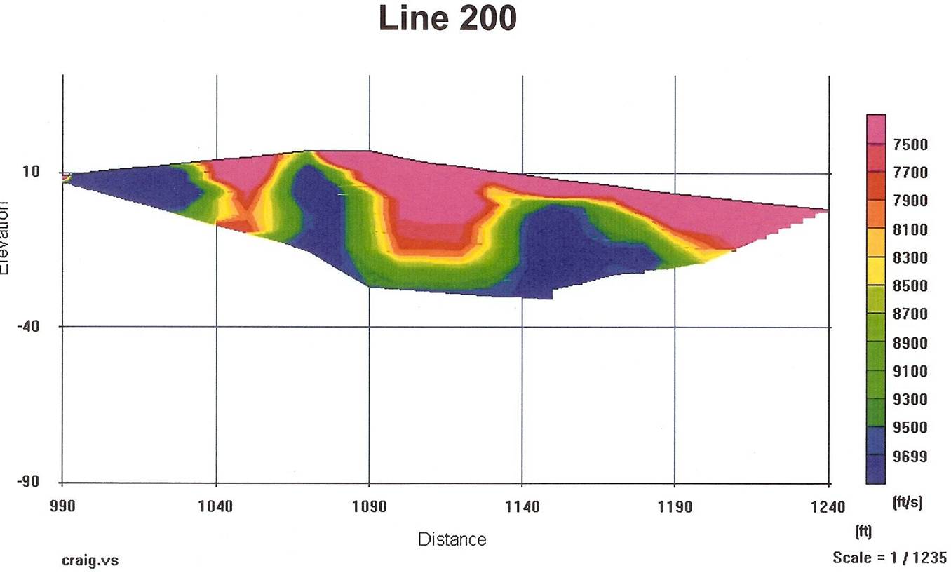
In regards to the seismic studies, some refraction gear was rented about 10 years ago and had good success with it. It was older equipment and was doing the surveys by myself. This is one of the pits found then:
A few years ago gear was rented again, it was greatly improved, could use my own laptop, and had someone to run the computer while I swung the hammer. There are 3 of the results found below. 5000 was the big Kahuna; the entire hillside has been disturbed. 2000 turned out very well also. 3000 doesn’t look as good, but the subterranean structures are rock outcrops on the surface.
http://mollymarieprospect.com/tomograms/2000.pdf
http://mollymarieprospect.com/tomograms/3000.pdf
http://mollymarieprospect.com/tomograms/5000.pdf
Below is a google earth photo with the lines above labeled. Each of the geophone lines shown revealed a pit. Some lines did not and are not shown.
What is maddening is there is intense alteration around these, especially 5000, but the gold assays are not great. There is intense silicification surrounding 5000 and lots of drusy quartz. That is the way these deposits are; the ore-waste margin is razor thin and the core has been removed and filled with rocks and dirt. There have been several good assays, but not enough to scream about. Many, many more suspected pits have been found after the last seismic work. I’ve run into something lately regarding the pits that is highly unusual and should have some more news soon.
It has been estimated by some that there were over 400 people working the mines north of Superstition Mountain for over a century and more; it is a story that must be told.
cuzzinjack

So, here is a photograph of the site on Canyon Lake. As you can see, the water has been lowered. About a fifth more of the hillside is exposed. A white line marks the maintained shoreline (NaCl?). Heavy erosion at this site, the intersection of three fault lines.
If the Peralta-Fish Map is correct, we are looking at the location of three lost Peralta mines.
Image: Panoramio 2009