Thanks Paul for replying
and for the aerial link!
I've been looking for early aerial photo's of Phoenix
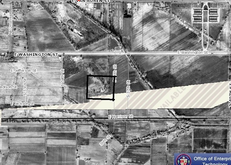
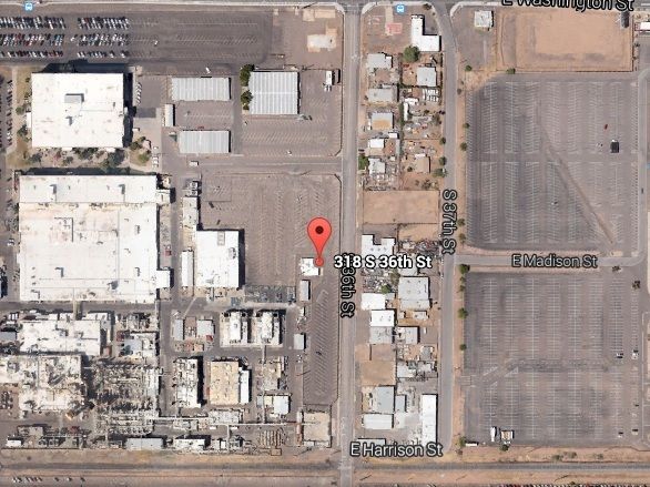
I'll have to take some time to study it
it sadden me if I wrong about finding Dutch's Ditch
but o well....finding anything to do with the LDM is difficult
I'll reconnaissance the area again and see what photos I can get
perhaps you can tell me something about St. Mary Church
in the abandon field at 16st & Buckeye ?
I found this red jasper stone there
and made this heart to commemorate the church
ED
really glad you took the time to update and post !
Dutch Ditch
Moderator: Jim_b
-
- Posts: 8
- Joined: Wed May 20, 2015 1:01 pm
- anti-spam detector: No
- The middle number please (4): 4
Re: Dutch Ditch
No problem, Ed
I also initially thought you had found a remnant of the DD until I saw the 1930 aerial and, while very close, photographs don't lie.
I am curious as to what was the origin of the historic ditch remnant that you did find, and if it had a name or not.
I did find a few "remnants" of the Dutch Ditch that still exist.
One runs through the front yards of the houses on the west side of 12th St, between Cocopah & Pima.
It's now an open drainage ditch that runs through the front yards, and it's obviously not as wide now as the DD originally was...but it is in the exact DD route.
The other is an open concrete-lined drainage ditch that runs along the north side of Air Ln from 24th St to 32nd St, just south of the railroad tracks. (Harrison turns into Air Ln at 24th St). Again, obviously this isn't how the DD originally looked, but it is the exact spot and the exact route.
The really cool thing about that historical aerials site is the ability to compare two different years of aerials side by side, such as 1930 & modern day. But be warned, once you get into that website you will lose track of the hours...lol!
Sorry, but I really don't know much about the church in that field. I've been more focusing on the historic and prehistoric canals in the Phoenix area lately.
This "urban archaeology" stuff is very interesting and very addicting!
-
- Posts: 8
- Joined: Wed May 20, 2015 1:01 pm
- anti-spam detector: No
- The middle number please (4): 4
Re: Dutch Ditch
Here are a few pictures of the "remnants", so to speak.
https://www.google.com/maps/@33.4326145 ... a=!3m1!1e3
https://www.google.com/maps/@33.433176, ... xEJZNA!2e0
https://www.google.com/maps/@33.432816, ... ZJHSiA!2e0
https://www.google.com/maps/@33.432542, ... BUvA8A!2e0
https://www.google.com/maps/@33.4326145 ... a=!3m1!1e3
https://www.google.com/maps/@33.433176, ... xEJZNA!2e0
https://www.google.com/maps/@33.432816, ... ZJHSiA!2e0
https://www.google.com/maps/@33.432542, ... BUvA8A!2e0
- roc2rol
- Posts: 774
- Joined: Thu Feb 04, 2010 8:58 pm
- anti-spam detector: No
- The middle number please (4): 4
- Location: Dutch's Ditch, AZ
Re: Dutch Ditch
Thanks Paul for posting the links
especially the 12st link!
hhhmmm….so that canal is the remnant of the original DD?
That what I thought years ago when I went exploring.
But when I saw the cut out of the larger canal I assumed
that must have been the original DD.
Dutch’s Ditch had to be huge to my way of thinking.
It had crossed my mind that the 12th street canal was originally larger
and could have been the DD path.
Unfortunately I haven’t quite figured out reading the aerial maps.
Truthfully, in the 1930 one I don’t see the Dutch Ditch path?
But I’m bad at map reading (another LDM flaw)
and at navigating the computer simulation.
I’ll figure it out eventually.
That’s interesting about Airlane.
Please tell me the path of Swilling Canal and if you know the location that Swilling had his adobe castle?
Thanks!
Ed
-
- Posts: 8
- Joined: Wed May 20, 2015 1:01 pm
- anti-spam detector: No
- The middle number please (4): 4
Re: Dutch Ditch
About the easiest way that I know of to tell you how to see the DD on that aerials site is to click on the search button (magnifying glass) and in the street intersection box, type in 14 St and Buckeye and hit go. Then go to change aerial and then view a single year aerial and scroll down and select the 1930 aerial. You may have to either zoom in or back out of the map to get the best view, but you should see a tree-lined ditch running diagonal from northeast to southwest. This is the Dutch Ditch. Just move the map back or forth to follow it's route. Or follow the route that I posted in my first post. Using the 1930 aerial, you should be able to see it's route quite easily.
Another thing that makes finding it's exact modern day route quite easy is the "compare two years of aerials" feature on this site. Just click on that and then click on the modern day view (2013) for the left side, and then click on the 1930 view for the right side. The screen will then be a split view with a slider button in the middle. Simply slide the button left or right to switch views back and forth. This is exactly how I found that 12th St and Cocopah/Pima remnant. You can also see that the DD in 1930 was about twice as wide as the ditch is now. Who knows, it may have been wider than that in the 1870s/1880s.
And this is just pure speculation on my part, but I don't think the DD was ever as wide as say the Grand Canal or the Arizona Canal. I'm not positive about that though.
As for Swilling's Castle, aka Dos Casas, here is a pic of the remnants of it from 1930, As you can see, it was on the piece of land between the Salt River Valley Canal (Swilling's Ditch) and the Maricopa Canal. In the modern day it would be near 36th St & Madison.
And here's where that location is today. In the parking lot of Honeywell, where the marker on the map is.
You can drive right to where that spot is, but it's now just a parking lot. No sign or plaque or anything.
I hope this helps you out. Cheers!
- roc2rol
- Posts: 774
- Joined: Thu Feb 04, 2010 8:58 pm
- anti-spam detector: No
- The middle number please (4): 4
- Location: Dutch's Ditch, AZ
Re: Dutch Ditch
Helps immensely Paul !
I’ll have to follow the path of the DD
In the LDM folklore the DD cut through Waltz’s land.
Those lots were quite large.
Supposedly Waltz help dig some of that ditch
As a laborer for Swilling? Tight for cash? Who knows?
But wherever he dug-- I want to look Ha Ha
As I understand it Dutch Ditch was implemented to bring water down from Swilling Ditch to irrigate that area of the original Phoenix town site. That seems a bit backwards to me-- as the Salt River was right there. But I suppose it had something to do with the grade of the land?
And Swilling Casa!
I always imagine he had gold stashed.
He wasn’t just a ditch digger.
That was just a front for the larger ideal.
Finding the Hohokam cache.
O I’m telling tales out of school .
I will remarks this though.
Reading LDM literature sure does illuminate a different perspective on Arizona
& especially Phoenix’s history.
Thanks for reviving the thread. I hope others find it interesting.
Ed
-
- Posts: 8
- Joined: Wed May 20, 2015 1:01 pm
- anti-spam detector: No
- The middle number please (4): 4
Re: Dutch Ditch
No problem, Ed!
I agree, it does seem like a long way to bring water...but you're right, it has everything to do with the grade of the land. The Salt River Valley basically slants from the NE to the SW, and those canals flowed via gravity, so....
Hey, I hope you find the LDM gold!
Me? Hell, I get excited even when I find the smallest of remnants of historic or prehistoric Phoenix that are visible in the modern day!
Talk to you soon...
- roc2rol
- Posts: 774
- Joined: Thu Feb 04, 2010 8:58 pm
- anti-spam detector: No
- The middle number please (4): 4
- Location: Dutch's Ditch, AZ
Re: Dutch Ditch
just a quick question
What do you think my picture is of?
It certainly look man made
Its not part of the gully that’s been mentioned
is it?
Thanks
Ed
What do you think my picture is of?
It certainly look man made
Its not part of the gully that’s been mentioned
is it?
Thanks
Ed
- roc2rol
- Posts: 774
- Joined: Thu Feb 04, 2010 8:58 pm
- anti-spam detector: No
- The middle number please (4): 4
- Location: Dutch's Ditch, AZ
Re: Dutch Ditch
ya know I got another interesting question
what is the difference between a canal & a ditch?
is canal a large waterway
and a ditch
just tributary?
what is the difference between a canal & a ditch?
is canal a large waterway
and a ditch
just tributary?
-
- Posts: 8
- Joined: Wed May 20, 2015 1:01 pm
- anti-spam detector: No
- The middle number please (4): 4
Re: Dutch Ditch
I'm not exactly positive.roc2rol wrote:ya know I got another interesting question
what is the difference between a canal & a ditch?
is canal a large waterway
and a ditch
just tributary?
I used to think that a ditch was much smaller than a canal, but then I find out that Swilling's Ditch was eventually named the Salt River Valley Canal, so I don't know.
It may just be a matter of whatever they felt like calling it...