Natural Bridges National Monument Utah
Horsecollar Ruin Site
Natural Bridges National Monument, the first National Park Service unit established in Utah, encompasses 7,636.49 acres. The pinyon and juniper covered mesa is bisected by deep canyons, exposing the Permian Age Cedar Mesa sandstone. Where meandering streams cut through sandstone walls, three large natural bridges formed. Sipapu and Kachina Bridges are the world's second and third largest natural bridges. Owachomo, while smaller, is only nine feet thick.
Natural Bridges National Monument is located in the Great Basin Desert on the Colorado Plateau of southeastern Utah. It is just southwest of the Manti-La Sal National Forest. Glen Canyon National Recreation Area runs both to the south and the west of Natural Bridges.
This area was repeatedly occupied and abandoned in prehistory, first being used during the Archaic period 2700 to 2500 years ago. Around 700 BC, Puebloans moved onto the mesa tops and began dry farming, but the area was later abandoned until about 1110 AD, when immigrants moved here from across the San Juan River and built single-family houses throughout the best watered areas. In the 1200s, farmers from Mesa Verde migrated here, but by 1300, all the ancestral Puebloans migrated south.

The Horsecollar Ruin site is a major attraction at Natural Bridges, and it is among the largest and best preserved ancestral Puebloan structures in the Monument. The name "Horsecollar" comes from the shape of the doorways to several structures here. Abandoned more than 700 years ago, its remarkable state of preservation -- for example, an undisturbed kiva with an original roof and interior design -- is due to the isolation of Natural Bridges and the relatively few visitors who make the journey down these canyons.
Exploration & Settlement
The Horsecollar Ruins were discovered by non-Indians in the late 1880s and were a source of interest for many visitors to the area. In 1907, they were first recorded by an expedition which later recommended the establishment of Natural Bridges National Monument, designated the following year. Sometime thereafter, they seem to have been forgotten until they were rediscovered by Zeke Johnson, the first curator of the Monument, in 1936.
Kachina Bridge
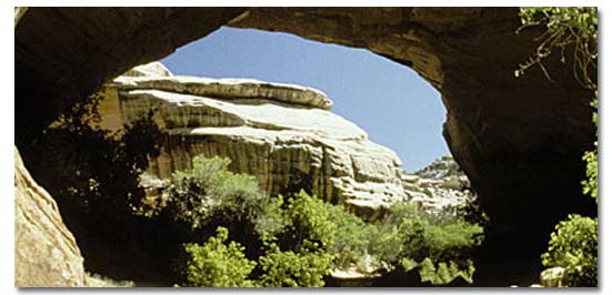
Kachina is the middle bridge. It spans the canyons equidistant between Owachomo and Sipapu bridges. It is larger than Owachomo but smaller than Sipapu, with the smallest opening of the three. It is thought to be the last to have formed. Approximately 4,000 tons of sandstone fell from the inside of the Kachina bridge opening in June, 1992, enlarging the opening considerably.
Height: 210 feet
Span: 204 feet
Width: 44 feet
Thickness: 93 feet
Sipapu Bridge

Sipapu is the largest and most spectacular of the three bridges in the Monument. It is considered "middle aged," older than Kachina but younger than Owachomo. Its rounded opening and smooth sides are mute evidence of countless floods bearing scouring rocks and sand. This bridge would easily house the dome of the United States Capitol.
Height: 220 feet
Span: 268 feet
Width: 31 feet
Thickness: 53 feet
Owachomo Bridge
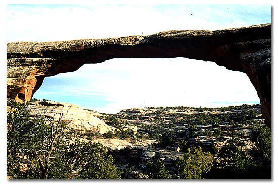
Owachomo is the smallest and thinnest of the three natural bridges here and is commonly thought to be the oldest. We may never know for certain, as each of the bridges certainly have eroded at different rates. Regardless of its relative age, it is certainly the most fragile and elegant of the three spans.
Height: 106 feet
Width: 27 feet
Span: 180 feet
Thickness: 9 feet
Park History
In 1883, prospector Cass Hite wandered up White Canyon from his base camp on the Colorado River. Instead of gold he discovered three magnificent natural bridges water had sculpted from stone. National Geographic magazine later publicized the area. In 1909, President Theodore Roosevelt designated the area a national monument.
Natural History
Plants & Animals
Wildlife abounds in the monument, but bobcats, coyotes, bears, mule deer and mountain lions remain to themselves while evading humans. Birds, rabbits and lizards are commonly seen.
Pinyon and juniper dominate the mesa top near the visitor center. Grasses and shrubs grow in lower areas, and where water is common, perennial cottonwoods and willows grow. Numerous species of wildflowers, common to this region of the high Great Basin Desert, grow in abundance April through June.
Geology
Natural bridges are formed where deeply entrenched streams undercut and break through fins of rock that separate their meander loops. Once the stream has broken through creating the natural bridge, it then takes the more direct route. Arches, on the other hand, are formed by frost and seeping water erosion.
At Natural Bridges National Monument, entrenched meanders of White and Armstrong creeks cut deeply into the Cedar Mesa sandstone, a pale, cross-bedded, windblown sandstone of Permian age. The three natural bridges in the Monument illustrate three stages of bridge development.
Kachina represents the early stage, thick and massive, with a relatively small passage. Sipapu Bridge is thinner and the stream below it is no longer wearing away its abutments. Owachomo Bridge, in the late stage of development, is slender and becoming frail. All of these bridges will continue to erode and eventually fall, while others continue to form due to the same processes.
Picnicking
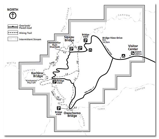
One picnic area along Bridge View Drive is located 2 miles west of the visitor center.
Auto Touring See map below
The nine-mile long Bridge View Drive is a one-way scenic loop starting and ending near the visitor center. Overlooks for each of the three bridges and one cliff dwelling are reached by short walks from parking areas along the drive. A trail head for each bridge is also located along the drive, as is a small picnic area. The road is plowed in the winter. While you can see all three bridges and one canyon archeological site from viewpoints along or near the road, you really haven't experienced the hidden beauty of Natural Bridges until you take at least a short walk below the rim or out onto the mesa top away from the pavement.
Biking
Bikes are not permitted on any trail or off-road area within the Monument.
Walking/Hiking
Loop Trail: A difficult 8.2 mile trail that connects all three bridges. It follows the canyon bottom stream for most of its length, then exits the canyon and ends on the relatively flat mesa top. It requires about six to eight hours to complete. The 8.2 mile loop can be split into two shorter loops, each taking in two of the three bridges. Each requires three to four hours and ranges from five to six miles in length, depending on the loop taken. Any of the loop hikes should be considered strenuous, since they require ascents and descents of up to 500 vertical feet. Monument elevations range from 6,000 to 6,500 feet above sea level.
Camping, Maps, weather, and what's nearby
Related DesertUSA Pages
- How to Turn Your Smartphone into a Survival Tool
- 26 Tips for Surviving in the Desert
- Death by GPS
- 7 Smartphone Apps to Improve Your Camping Experience
- Maps Parks and More
- Desert Survival Skills
- How to Keep Ice Cold in the Desert
- Desert Rocks, Minerals & Geology Index
- Preparing an Emergency Survival Kit
Share this page on Facebook:
The Desert Environment
The North American Deserts
Desert Geological Terms


