Zion National Park - Utah
Things to Do
Overview| Climate/Map | Description | Where to Stay | Nearby

Auto Touring
Theroads of Zion National Park introduce you to the the park's spectacular cliff-and-canyon landscape. You can drive, bicycle, or take a guided tram tour, depending on your time and interests.
Colorful canyon and mesa scenery includes erosion and rock-fault patterns that create phenomenal shapes and landscapes. Evidence of former volcanic activity is here, too. Interpretive road guides are for sale at the Visitor Centers.
Zion Canyon Scenic Drive, the Zion-Mt. Carmel Highway and the Kolob Canyons Road are open year-round. The Kolobs Terrace Road is usually closed by snow from late November to May.
If you are driving, remember the roads are designed for sightseeing, not speeding. They are narrow, winding, and sometimes steep. Obey posted speed limits.
If you want to stop, use a roadside parking area. Be alert for hazards, particularly pedestrians, bicyclists, wildlife, fallen rocks, and other motorists. Bicycles must be carried through the long tunnel in a vehicle.
All buses and many recreational vehicles are too large to pass safely through the long tunnel in two-way traffic. A fee is charged for the escort required for large vehicles to use the tunnel. During the busier seasons, large vehicles have restricted parking in Zion Canyon.
Zion Canyon Scenic Drive
A new bus transportation system will run during the busy season, March through October, and peak periods. One loop will include nine stops in Zion Canyon, and a second will include six stops in the town of Springdale. Parking will be available throughout Springdale and inside the south park entrance.
It will be possible to leave your vehicle in town and ride the shuttle to the new Zion Canyon Visitor Center or park right at the visitor center. There, exhibits and audio visual presentations will help you plan your visit.
The visitor center will be the start of the Zion Canyon loop into the park. Shuttles will depart each location often throughout the day. You may get on and off the shuttle as many times as you wish. Riding the shuttle on both loops is free. The cost of the shuttle system is included in the park entrance fee.
All visitors, except those staying at Zion Lodge, will use the buses to access Zion Canyon. You will still have the option of biking or hiking along the canyon's scenic drive. The Pa'rus Trail connects Zion Canyon to the new visitor center and both campgrounds. The east side of the park will remain accessible by private vehicle.
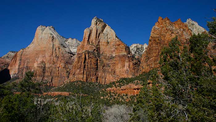
13.2 miles round-trip: Sheer, vividly colored cliffs tower above as you follow this road along the floor of Zion Canyon. This narrow, deep canyon is the centerpiece of the park. It awed early visitors like Frederick Vining Fisher, a Methodist minister, who named the Great White Throne, Angels Landing, and many other monoliths. Today, the canyon continues to spark a sense of wonder and disbelief in those who come and stand beneath its 2,000- to 3,000-foot-high walls.
Along the bottom of the canyon flows the Virgin River. It is a river with the looks of a creek and the muscle of the Colorado. This small river almost single-handedly carved the profound rock gorge of Zion Canyon. It began its down-cutting more than 13 million years ago and continues its work today. You may witness the river's power during a flash flood, when it turns muddy and violent, carrying cottonwoods and boulders, twigs and pebbles alike.

On most days, though, the Virgin River winds through the canyon peacefully. Fremont Cottonwoods, willows, and Velvet Ashes along its banks provide shady spots for a picnic or a short walk. Mule Deer and many birds, too, seek refuge from the extreme midday heat of summer beneath this canopy. Other wildlife, including Ringtail Cats, Bobcats, foxes, Rock Squirrels, and Cottontails, rest under rocky ledges.
The best times to see animals along the road are early morning, evening, and at night when they are most active. These are also ideal times to see the conspicuous white trumpet-shaped flowers of the Sacred Datura. This common roadside plant is also called moonlily because its blossoms open in the cooler hours of evening and wilt with the rising heat of the day.
Anasazi and Paiute Indians may once have lived in Zion Canyon year-round; Mormon settlers did. They were here in Summer, when dramatic thunderstorms send dozens of waterfalls, large and small, cascading off the cliffs; in Autumn, when the green canyon trees turn gold; in Winter, when light snow dusts the rocks; and in Spring, when wildflowers fed by melting snows bloom. You may want to sample different seasons on your visits to Zion Canyon.
Zion-Mt. Carmel Highway
11 miles one-way: Outstanding works of man and nature compete for attention along this route. The road, completed in 1930, was considered an "almost impossible project," an engineering marvel of its time. Built across rough, up-and-down terrain, it connects lower Zion Canyon with the high plateaus to the east. Two narrow tunnels, including one 1.1 miles long, were drilled and blasted through the cliffs to finish the construction job.
As you travel from one side of the long tunnel to the other, the landscape changes dramatically. On one side lies Zion Canyon with its massive cliff walls. The colossal size of the canyon is matched by one of the most striking attractions along this road -- the Great Arch of Zion, a "blind" arch carved high in a vertical cliff wall.

On the other side of the tunnel is slickrock country. Here, rocks colored in white and pastels of orange and red have been eroded into hundreds of fantastic shapes, etched through time with odd patterns of cracks and grooves. The mountain of sandstone known as Checkerboard Mesa stands as the most prominent example of this naturally sculptured rock art.
Roads to the Kolob
Two roads lead into the northwestern corner of the park, where streams have carved spectacular canyons at the edge of the Kolob Terrace. The Kolob Canyons Road (11 miles round-trip) enters the park from l-15 at exit 40 and penetrates 5 miles into the red rock, perpendicular-walled Finger Canyons, ending at a high viewpoint.
The Kolob Terrace Road (50 miles round-trip) overlooks the white- and salmon-colored cliffs of the Left and Right Forks of North Creek. It is accessed from the town of Virgin, south of the park, and is closed by snow from November to May
Both routes climb into forests of Pinyon and Juniper; Ponderosa Pine, fir, and Quaking Aspen are found at Lava Point. In Summer, there is often a feel of mountain coolness to the air atop the Kolob's high country plateaus. And in the early Spring, the Kolob is buried under a thick snowpack. The sparkling white of the snow heightens the colors of this already colorful landscape.
Picnic Areas
There are two picnic areas in Zion National Park, the Grotto Picnic Area in Zion Canyon and a site at the end of Kolob Canyons Road. The Grotto has fire grates, picnic tables, water and restrooms. The Kolob site has tables, fire grates and pit toilets.
BACKPACKING:
Permits are required for all backcountry camping. The cost is $5.00 per permit. Maximum group size is 12 people, including all leaders. Permits and hiking information are available at both visitor centers.
BICYCLING:
Bicycles are permitted only on established roads and the Pa'rus Trail. Cyclists must obey traffic laws. Bicycles are not allowed on hiking trails or off-trail. Ride defensively; automobile traffic is often heavy and drivers may be distracted by the scenery. Riding through the Zion-Mt. Carmel Tunnel is prohibited. Bicycles must be transported through by motor vehicle.
CANYONEERING
Permits are required for all through hikes of the Narrows and its tributaries, the Left Fork of North Creek (the Subway), Kolob Creek, and all canyons requiring the use of aid. The Subway is limited to 50 people per day. Narrows and all slot canyon permits are available the day before you hike, and all other hiking permits are available up to 3 days before you hike. Cost is $5.00 per permit for all backcountry permits due when you pick up your permit. Have the following information ready when you pick up your permit: Vehicle description and License Plate Number. The maximum group size is 12, including all leaders.
CLIMBING
Climbing on Zion's sandstone requires appropriate hardware and techniques. Information on climbing is available at visitor centers. Climbing and rappelling is prohibited on the cliffs above Middle and Lower Emerald Pools and Weeping Rock. Some routes may be closed to climbing when Peregrine Falcons are nesting. A permit is required for climbing. Cost is $5.00 per permit. Visit the Backcountry Permit Desk for additional climbing routes and information.
Zion National Park
Springdale, UT 84767-1099
Vistor information 435-772-3256
Overview| Climate/Map | Description | Where to Stay | Nearby
Related DesertUSA Pages
- How to Turn Your Smartphone into a Survival Tool
- 26 Tips for Surviving in the Desert
- Death by GPS
- 7 Smartphone Apps to Improve Your Camping Experience
- Maps Parks and More
- Desert Survival Skills
- How to Keep Ice Cold in the Desert
- Desert Rocks, Minerals & Geology Index
- Preparing an Emergency Survival Kit
Share this page on Facebook:
The Desert Environment
The North American Deserts
Desert Geological Terms


