Did James Addison Reavis create The Peralta Stone Maps?
It has been suggested, even argued many times, that The Peralta Stone Maps, were made by James Addison Reavis, as part of his Claim to be a rightful Heir to the "Peralta Land Grant".
According to an article written by Tom K. The Baron Of Arizona the fraud started around 1880 and ran until the mid 1890's.
From Tom's article: "Reavis arrived in Arizona Territory about 1880, making claim that he owned a large part of Arizona and New Mexico territory that included Phoenix, Tucson and Mesilla. Reavis amassed a fortune from collecting rent and tribune from railroads, ranches, farms, and mines for about eleven years. Many of the Arizona pioneers preferred to pay his extortion rather than fight him in court.
Finally, the U.S. District Court challenged Reavis’ claims to Arizona and New Mexico. The case had been on the docket since Feb. 1, 1893, in the United States Land Claims Court, but still had not gone to court even by Feb. 1, 1895. Reavis had collected money from the Southern Pacific Railroad for right-of-way and from various mines in Arizona Territory through out this period of time. After losing his case in the U.S. District Land Claims Court, Reavis was soon indicted in a criminal court.
The criminal court proceeding began on June 27, 1896. Reavis was convicted and sentenced to two years in prison for trying to defraud the U.S. Government. He served his time in the Santa Fe, New Mexico Penitentiary and was released early, on April 19, 1898, for exemplary conduct during his imprisonment."
Full article at:
http://www.superstitionmountain.info/ch ... 07_08.html
If Tom's dates are correct... That would make it a real "Pinch Fit" to connect Reavis to the Stone Maps. Even if he made them at the very beginning of his scheme. (1880)
Back just before the turn of the century (1900 - 2000) I spent a week camped at the old windmill, at the end of the road past the old Tortilla Ranch with Bob Corbin. While sitting around the campfire one night he told me a story about an FBI examination that was performed on the Stone Maps back in the late 1960's. His exact words escaped me, and for a long time all I could was paraphrase them. The more I repeated the story, the more it started getting repeated by others, until Greg Davis heard it and contacted me for the specific details. I told the story to Greg as well as I remembered it, and suggested that he contact Bob Corbin, and get the story directly from him. Greg wrote a letter to Bob requesting the details of the FBI examination of the stone maps that occurred back in the late 60's. In May of 2005 Greg received a written reply from Bob via the U.S. Mail, and emailed me a copy of it. A copy of that email (containing Corbin's letter) is below.
From: Greg Davis
Date: Tuesday, May 03, 2005
To: j.hatt@XXXXXXX
Subject: Stone Maps/Corbin
"It was approximately in the late 1960's, I believe, that I was at the U.S. Attorneys office in Phoenix, when one of the Deputy U.S. Attorneys told me that an FBI agent from the FBI laboratory in Washington DC was in their office. Apparently, the Phoenix office had obtained the stone maps to have them analyzed by the FBI laboratory to see if they were recent fakes. He asked if I would like to speak with the agent since I was interested in the Lost Dutchman Mine and I said I would. I spoke with the agent and asked him what they had found in analyzing the stone maps. He told me that they believed the maps were at least a hundred years old. To my recollection that's all he said about the maps.
Bob Corbin."
(Jim , Bob was not the attorney general at the time but working for the state or county in some legal capacity, Greg)
Bob Corbin had told me years earlier, that he had loosely concluded from the time frame given in FBI's opinion, that the stone maps were probably connected somehow to the Land Grant Fraud case, and he never gave them any more thought.
Using the information from Bob Corbin's letter, pertaining to the FBI's opinion of the age of the stone maps, "At least 100 years old" in the late 1960's, and the dates pertaining to the Reavis case, from Tom Kollenborn's article. The Land Grant Fraud case does not date back far enough to take you back to 100 years prior to the date the FBI examined the maps. That does not even consider the fact that the FBI said "At least 100 years" old in the late 1960's, and the maps could actually be even older than the late 1860's.
None of this is "Hard Evidence" of anything. It is all subject to the memory and credibility of the sources, but in both cases (Bob Corbin and a representative of the FBI Labs in Washington D.C.) I cannot think of any two sources that would come with more credibility!
If you accept them (as I do) it totally eliminates the possibility that James Addison Reavis had anything to do with making the Peralta Stone Maps.
Jim Hatt
James Addison Reavis & The Peralta Stone Maps
Moderator: Jim_b
-
gollum
- Posts: 258
- Joined: Fri Mar 05, 2010 7:41 pm
- anti-spam detector: No
- The middle number please (4): 4
- Location: http://www.1oro1.com
- Contact:
Re: James Addison Reavis & The Peralta Stone Maps
Jim,
To be fair to all sides, there is no way to definitively date the Stone Maps. If they "COULD" have been made much earlier than the 1860s, then they also "COULD" have been made a bit later (20-30 years). Although, I would think that if Reavis had them made to bolster his claims, there would have been some mention of them in the legal records as was the fake Land Grant Certificate.
Just like Carbon14 Testing can give you an approximate date range, the ONLY way to determine age of the Stone Maps might be surface patina/varnish (that's tough due to the fact they were found buried). Spectrographically Testing minute metal fragments that might be found in the grooves for the type of alloy.
Everything about them is tough. You either believe or you don't.
Best-Mike
-
Jim Hatt
Re: James Addison Reavis & The Peralta Stone Maps
Hi Mike,
Radio Carbon Dating is something that is right up my alley. I did an article about why it cannot be used on the stone maps because of the absence of organic material at:
http://www.desertusa.com/mag06/oct/peralta.html at:
Even if some organic material could be found on them, the LLD (Lower Limit of Detection) for Carbon Dating is several hundred years due to the extremely long half-life of it. Estimates of age based on Carbon 14 tests on objects less than 600 years old are not very reliable at all.
If there were bits of tool metal still to be found them, it would be either Iron or Steel. The changeover from iron to steel took place during the period from around 1910 to 1920. This was when they started adding carbon to the iron to make it steel (harder). If it were determined that iron (no steel) could be found anywhere on the maps it would tell us that they were made before 1910, but not how long before. I have been all through that process, with a short length of forge welded chain I found not far from the old Tortilla Ranch.
Patina is a different story. It can still be a factor to be considered on objects that have been buried. Exposure to air and sunlight, are not the only things that cause it. Contact with other minerals, extreme temperatures and water, can also contribute to the formation of patina. And... Don't forget, One of the stones was partially exposed.
If there is any chance for dating the age of the maps, I think it would only be by testing the age of the glue, used to repair the broken heart stone. Of course that would not tell you when they were made. At best it could only place a date on when the heart was broken and repaired, but that could take them back a LONG ways.
Right now it seems to be a moot point, because the SMHS has no intention (at this time anyway) of asking the M&MM for permission to have any tests performed on them.
Best,
Jim
-
oroblanco

- Posts: 263
- Joined: Fri Jan 01, 2010 11:01 am
- anti-spam detector: No
- The middle number please (4): 4
- Location: Black Hills, Dakota Territory
- Contact:
Re: James Addison Reavis & The Peralta Stone Maps
Hola amigos,
I have major problems with the Reavis theory - for one, Reavis never mentioned them (even though he did make fake stone-carved land marker monuments, he didn't try to HIDE them by burying) the maps themselves are nothing like any kind of land-claim or property boundary map, and most important of all - they don't have the name he was using to tie his fake land grant to anywhere on them - PERALTA. Interesting theory of origin, but too many problems with this idea for me.
Roy
-
Jim Hatt
Re: James Addison Reavis & The Peralta Stone Maps
I couldn't agree with you more Roy.
There isn't a thing on the maps that would have helped Reavis establish his claim to be heir to the Land grant, or even show the boundaries of it. Which still leaves us with the big question... If Reavis didn't make them. Who did?
Best,
Jim
There isn't a thing on the maps that would have helped Reavis establish his claim to be heir to the Land grant, or even show the boundaries of it. Which still leaves us with the big question... If Reavis didn't make them. Who did?
Best,
Jim
-
oroblanco
- Posts: 263
- Joined: Fri Jan 01, 2010 11:01 am
- anti-spam detector: No
- The middle number please (4): 4
- Location: Black Hills, Dakota Territory
- Contact:
Re: James Addison Reavis & The Peralta Stone Maps
Jim Hatt wrote
 We just might get the answer to that question, if someone finds what it is and will say so in public.
Roy
It seems doubtful that we can ever KNOW the answer to that; I think it is safe to say that none of us <here> made them however. A more important question (in my opinion) is what do they lead to? Is it a map to mines & caches, or some kind of treasure vault, or graves of missionary padres or....?Which still leaves us with the big question... If Reavis didn't make them. Who did?
Roy
-
Jim Hatt
Re: James Addison Reavis & The Peralta Stone Maps
Roy,
I have no evidence to support this beyond what De Grazia put in his book, about the Jesuits stashing a large hoard of treasure in the superstitions, but my gut feeling is that they lead to both mines and buried treasure. According to De Grazia's book they hid treasure in the Superstition Mountains somewhere in the vicinity of Weaver's Needle.
I lean towards believing that the 3 circles with dots in them (shown on the horse map) are mines, and the 2 double circles (shown on the priest map) are are sealed mines with treasure in them.
Like you said... We will probably never know until someone pinpoints the locations, and maybe not even then!
Best,
Jim
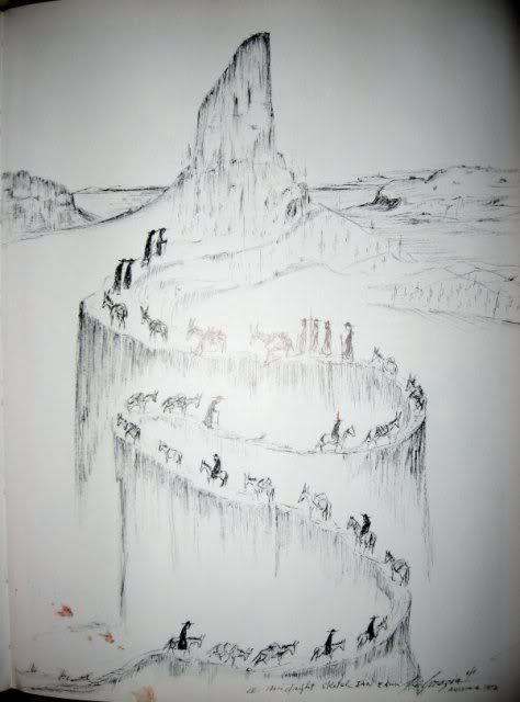
De Grazia's depiction of the Jesuits carrying their treasure to Weaver's Needle.
From his book: De Grazia and his Mountain The Superstition
I have no evidence to support this beyond what De Grazia put in his book, about the Jesuits stashing a large hoard of treasure in the superstitions, but my gut feeling is that they lead to both mines and buried treasure. According to De Grazia's book they hid treasure in the Superstition Mountains somewhere in the vicinity of Weaver's Needle.
I lean towards believing that the 3 circles with dots in them (shown on the horse map) are mines, and the 2 double circles (shown on the priest map) are are sealed mines with treasure in them.
Like you said... We will probably never know until someone pinpoints the locations, and maybe not even then!
Best,
Jim
De Grazia's depiction of the Jesuits carrying their treasure to Weaver's Needle.
From his book: De Grazia and his Mountain The Superstition