The "PERALTA STONE MAPS"

Moderator: Jim_b

Post Reply
Jim Hatt

The "PERALTA STONE MAPS"

Post by Jim Hatt »

Please read before posting in this discussion....

I have no interest in converting anyone into believing in the authenticity of the stone maps. This particular discussion was created, so that those who already believe in the their authenticity, can discuss them without constantly being annoyed by the non-believers.

Generally people who believe in the authenticity of the stone maps, have many years of research and/or time on trail out in the Superstitions involved in forming their opinion that the maps are authentic, and they are not interested in hearing why someone else thinks they are frauds, manufactured for some kind of scam.

Anyone who wishes to share opinions along that line, should state them in the discussion titled Are the stone Maps Authentic or are they a Hoax? at:

http://www.desertusa.com/mb3/viewtopic.php?f=19&t=1500


The owners and operators of DesertUSA.com, state no opinions about the authenticity of the stone maps. The opinions stated in this discussion are those of the individual posters.


THE ORIGINAL TWO TRAIL MAPS AND THE PRIEST/HORSE STONE ARE CURRENTLY ON DISPLAY AT THE SUPERSTITION MOUNTAIN MUSEUM ON HWY 88 (4087 N. Apache Trail) IN APACHE JUNCTION, ARIZONA. THEY ARE SCHEDULED TO BE THERE ON LOAN FROM THE MINERAL & MINING MUSEUM FOR A PERIOD OF 2 YEARS.

High resolution photographs of the original stones are available on this site at:
http://www.desertusa.com/mb3/viewtopic.php?f=10&t=470

The Peralta Stone Maps are my favorite topic.

I currently believe them to have been made in 1751 and updated in 1767.
1751 being the time period that the map makers were working the mines shown on the maps, and 1767 being the date of their last visit to the area and several caches were made.

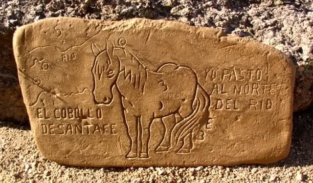
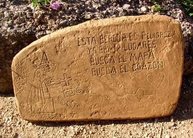
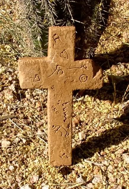
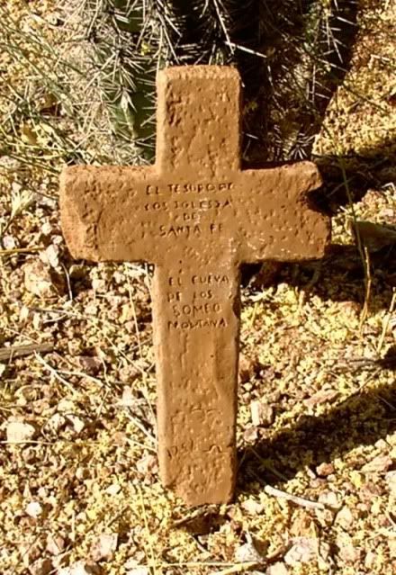
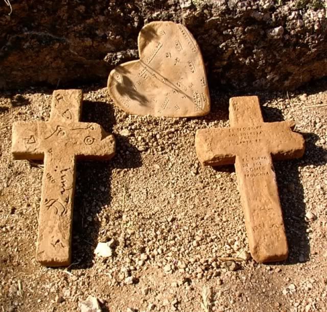
The complete set of maps consisted of 7 stones.

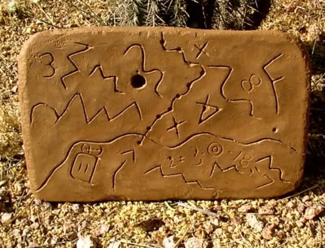
The bottom Trail Map
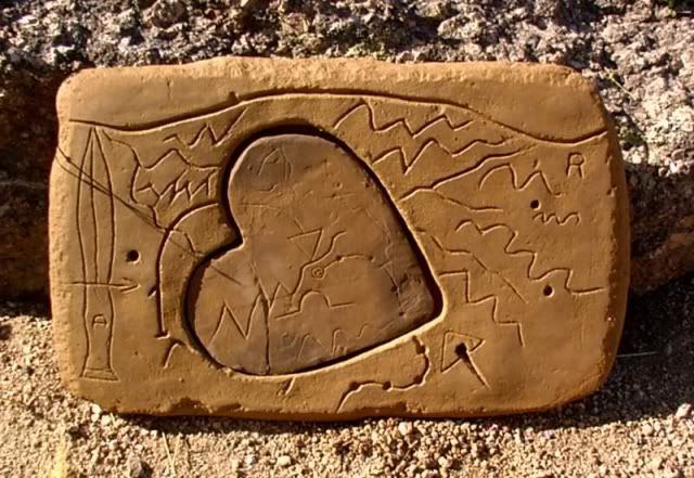
The Top Trail Map with the heart cavity cut-out
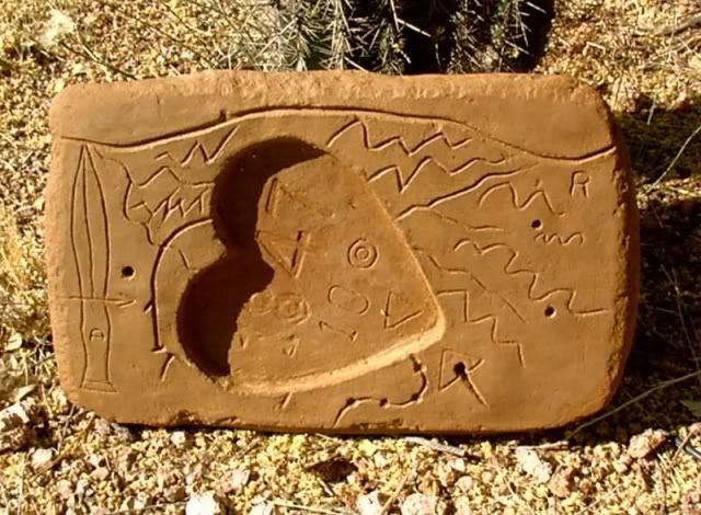
The Priest/Horse Map (opposite sides of the same stone)
Stone Cross with text only
Stone Cross with Map and text
Heart insert with end of the trail
Latin Heart (insert with Latin words on one side and Roman Numerals on the other)

NOTE: The photo below shows 8 stones but the Priest/Horse stone is separated to show both sides at the same time. On the original stone these images are back to back on the same stone.


Image


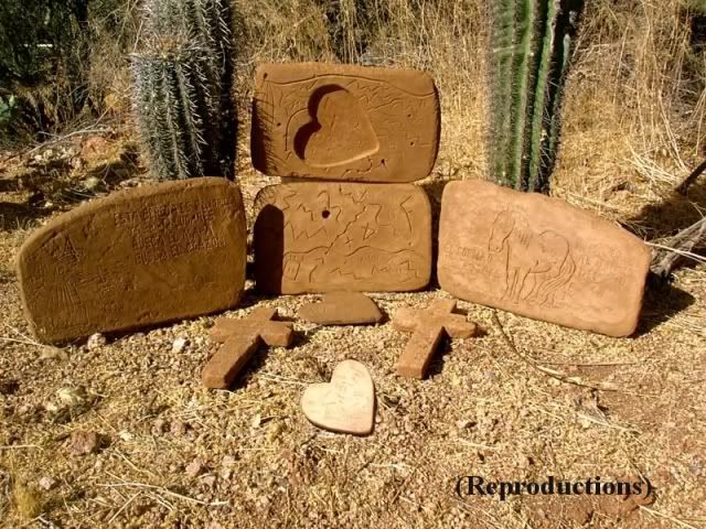
Individual photos of each stone below. These are photos of a set of reproductions currently owned by "maptech" who lives in So. Calif. and has made many trips into the mountains to chase the legends and Lore of the Superstition Mountains. He has made a number of very interesting posts concerning his theories about the stone maps in other areas of this website. His most interesting theory concerns the 8-N-P scratched in near the bottom of the Priest map. I will bring that post to this tread as soon as I am finished uploading all of the photos.


Image


Image


Image


Image


Image


Image


Image


Image

More information, and some alternate opinions, on the Peralta Stone Maps can be found at the links below:

http://www.desertusa.com/ldm-1/peralta.html
http://www.desertusa.com/mag06/oct/peralta.html
http://www.desertusa.com/mag02/june/ld1.html
http://www.desertusa.com/mag02/sep/per_stone.html
http://www.desertusa.com/mag98/aug/stories/lost1.html
Last edited by Jim Hatt on Mon Jul 06, 2009 6:45 pm, edited 3 times in total.
Jim Hatt

Maptech's Theory about when the Stone Maps were made

Post by Jim Hatt »

This was originally posted in another section of this website titled ` Dating the Peralta Stone Maps which is located at: http://www.desertusa.com/mag06/oct/peralta.html

It has been removed from there and re-posted here.


Date of the stone maps
Maptech AKA: Rex Western
Southern California

It might be a little easier putting a date on the stone maps by utilizing information that was available during the time they were made and comparing it to information that was available in 1949 when they were discovered, and information available today. For example, all maps need a relatively fixed point to navigate by. In early navigation, this point was either the pole star, or magnetic north.

Anyone who navigates by maps knows that both the pole star is not fixed nor magnetic north. In 2012 A.D. we will be changing pole stars to Draco. This due to the fact that Polaris will move far enough from the pole position as Draco moves in. Hence the long count calendar renews.

Magnetic north moves erratically. Isogonic lines on aviation charts must be redrawn or renumbered every 10 years due to the fact that magnetic north constantly changes. Any map that is intended to be accurately navigated by, must contain an Isogonic drift to make compass corrections by. On the priest map, you will note the code " 8-N-P " This is the Isogonic drift deviance. ie. from the point of navigating this map, North Polaris is 8 degrees from magnetic north. Hence 8-N-P. is 8 Norte Polaris.

Now, if you use the geomagnetic calculator software developed in 1979 and enter in the lat and long of Weavers Needle and the magnetic variance of 8 degrees, it will churn out the date of March to May of 1767. This is the only time magnetic north was 8 degrees off from the pole star. Today it is around 11.5 degrees off and it has been as much as 14 degrees since 1767.

The only time this information was at hand was when the map was made and after 1979. In 1949 when the magnetic variance was 13+ degrees, and when the maps surfaced, nobody knew what the magnetic variance was in 1767.

The Jesuits were expelled in 1767 from New Spain. Nobody in 1949 would be able to know what to put as a magnetic drift if they were making a fake map. A computer program had to take the Isogonic lines from every map in existence and compute all the variances and fill in all the blanks.

There are no maps in existence of the Arizona region with Isogonic lines anywhere near that time period. It would take a master map making genius to fake the Peralta stones, or a Jesuit in 1767 to produce them.

User avatar
Catclaw
Posts: 11
Joined: Mon Jul 06, 2009 7:01 am
anti-spam detector: No
The middle number please (4): 4
Location: 1/2 A Mile From Tucson

Re: The Peralta Stone Maps

Post by Catclaw »

Jim Wrote: "In 2012 A.D. we will be changing pole stars to Draco. This due to the fact that Polaris will move far enough from the pole position as Draco moves in."
Hey Jim, sorry to pull out something that wasn't even the gist of your post, but as far as Polaris ceasing to be the Pole Star in a mere 2.5 years, it just ain't so :-) See, Polaris is changing its position slowly, and won't be the pole star forever, but by the year 2102, (about 93 years from now), Polaris will still only be 0.4603° from the celestial north pole. (http://en.wikipedia.org/wiki/Pole_star) That's still DARNED close. Another thing is that Draco isn't a star, it's an entire constellation - one of the biggest of the 88 named constellations, as a matter of fact. It could quite possibly be that one of the stars in Draco will be our next pole star - I seem to remember something like this as a matter of fact - but none of us, or any of our kids, or theirs, will be around to witness it.

Thanks for the info on the Peralta maps! I'd never heard of them before. Fascinating stuff.

Catclaw
User avatar
Catclaw
Posts: 11
Joined: Mon Jul 06, 2009 7:01 am
anti-spam detector: No
The middle number please (4): 4
Location: 1/2 A Mile From Tucson

Re: The Peralta Stone Maps

Post by Catclaw »

Hey Jim,

And now I see it wasn't even you who wrote the original - states right there is was Maptech. Sorry for the mix up.

Catclaw
Jim Hatt

Re: The Peralta Stone Maps

Post by Jim Hatt »

Catclaw, Sounds like you know your stars! I bet you and maptech could have a conversation miles over my head about it. I tried researching the thing about Polaris myself on the Internet when he first made that post. Mostly I was just trying to understand what he was talking about. I got so much conflicting information about it that I just gave up. He sent me a copy of the Isogonic drift program and I played with some dates and co-ordinates in it, and it all came out the same way for me as it did for him.

You can download the Geographic Magnetic Calculator program free at: http://www.resurgentsoftware.com/geomag.html
if you want to play around with it and see what you come up with.

People have been trying to put a date on these stone maps ever since they were found. I would sure be a happy camper if the 8-N-P on the maps, actually was a correction factor that dates them to 1767 the way maptech believes it to be.

Attack this thing with all your might Catclaw. If it falls apart, we will all learn something and move on to something else.

Jim
Jim Hatt

Re: The Peralta Stone Maps

Post by Jim Hatt »

Catclaw, I was just looking at your post about Polaris and maptech's. I'll betchya anything the 2012 in his post is a typo for 2102. You know how it is when you are all worked up about something and trying to explain it by typing it out. Either way, it does not change the 8-N-P and Isogonic Drift relationship does it?

Jim
User avatar
Plays In The Dirt
Posts: 870
Joined: Sat Mar 28, 2009 5:51 pm

Re: The Peralta Stone Maps

Post by Plays In The Dirt »

Jim, pardon my lack of knowledge but were people that long ago sophisticated enough to create such cryptic maps, and why on earth would they go to such extremes? Knowing nothing about it I assume these maps led to some treasure of sorts? Will be interested to hear your reply, I find this interesting.

Greg (aka PITD)
Jim Hatt

Re: The Peralta Stone Maps

Post by Jim Hatt »

Greg,

I wish I knew all the answers to your questions. The best I can do is give you my opinion based on almost 20 years of working with these maps. That may sound like a lot of time to you, but there are people that have been working with them since they were first made public in LIFE Magazine back in the mid 1960's. The Jesuit Priests of the 1700's were among the most sophisticated, people on earth. They were educated in all known Sciences as well as the Religion of their time. Their navigational skills were second to none, and the sky was their chart that took them from place to place, be it upon the open sea, or across a barren desert. The sophisticated part of the maps is in the navigational data engraved on them. The cryptic part is in understanding how to use it, and recognizing the landmarks in the field that are shown on the maps. The date of 1751 appears at the bottom of the Stone CROSS with the words on it that translate to: THE TREASURE OF THE CHURCH OF SANTA FE. I believe this to be the date the maps were made. 1751 is an important date in Jesuit history as it was a year of massive Indian uprisings against the Jesuits. It has been written that the uprisings were caused by unfair treatment of Indian labor, used to work in Jesuit controlled mines in the "New World". I believe the maps were made during the time of the uprisings to document the locations of the richest of their mines so they could return to them later when the dust settled. 16 years later in 1767 the Jesuits were expelled from the New World by the king of Spain, for reasons that remain in sealed documents to this day. It is often speculated to be due to a dispute over the Kings Royal Fifth (Taxes) due from the mines, but there were major power struggles going on in Spain at the same time, so it could have been a combination of things. Legend has it that the Jesuits were forewarned of the coming expulsion and gathered their riches together from all of their churches in the Southwest, and cached it away before the Kings men arrived from Spain with the official order. If you can find the 8-N-P near the bottom of the Priest Map, you will notice that it is not as nicely and deeply carved into the stone as the other engravings are. It is as if it were hastily scratched in by someone other than the original artist. If maptech's theory is correct about that being an Isogonic drift correction for magnetic navigation, then that indicates a 1767 alteration to the maps that was made right during the period the Jesuits were believed to have cached away a very large fortune. Logic dictates that they would not have dug a hole to cache this Treasure in since they already had some major holes in the earth (Mines they had been working) that were already identified on the maps. All they needed was an updated (1767) correction for the magnetic deviation to identify which mine the treasure was cached away in before it was sealed up and concealed, until they could return to it. I have two articles about the stone maps on this website that can flesh out the whole story for you if you have the time to read them. There is another article about them here by Gene Botts that presents another opinion about the maps and comes to the conclusion that they are fakes. If you do a site search for Peralta Stone maps you should find all three and possibly one or two more.

I have a feeling that your next questions will be much longer and tougher after you have read all that is available on this site. I am not looking forward to trying to come up with answers for them.

Jim
User avatar
Plays In The Dirt
Posts: 870
Joined: Sat Mar 28, 2009 5:51 pm

Re: The Peralta Stone Maps

Post by Plays In The Dirt »

Jim,

Thank you for your comprehensive reply. I love to read (and learn) so when I get a little time I'll delve-in to this a little further. Meanwhile I'm going to spend the next two or three days exploring and shooting Photos here in the area of Nevada where I live. Thanks again...

Greg (aka PITD)
Yehonadav
Posts: 22
Joined: Wed Jul 08, 2009 12:22 pm
anti-spam detector: No
The middle number please (4): 4
Location: Moore, Oklahoma

Re: The Peralta Stone Maps

Post by Yehonadav »

Jim,

First off it's good to see you again and I hope all is well with you and those close to you. I know we've talked at lengh about the Peralta Maps and I want to apologize to you for any seeming mistrust toward you. The 1847 things on the top map always puzzled me but I think I know what it is refering to. Whenever a someone wants to find the exact location of something on a map, they usually use longitude and latitude to plot the point. I was looking on Google Earth today and starting at the river right near where some of the stones were found east of Florence Junction, I went north trying to follow the route that the top and bottom map took. Guess what longitude I landed at? 111degrees 18 mins 47 secs north. Now this doesn't seem to do us much good without the latitude numbers, but that is what the Peralta Map maker(s) were banking on. It let you know if you had gone too far east or west when locating the heart region which I believe the center of lines up with 111 degrees 18 mins 47 secs north. I started to think well did they have that kind of mapping capability back then? Yes they did from at least the first century they've had the ability to cartograph using coordinate gird. So these guys being expert cartographers surely could have used global positioning to leave clues for the seeker. I also know that these guys also have to be somewhat of mathematicians to do the cartography they did, because of all the calculations that would have had to go into finding coordinates, etc. Guys like that tend to be perfectionists which leads me to believe they would have things end in whole numbers. I made a rough guesstimate of how far I think they went into the wilderness, which I believe to be about 1 mile or so, I could be way off though. I have a Google Earth image to share below. Hope you give me some feedback as well as anyone else that cares to :).

Moderator Note: (Please reduce photo to 640 X 480 and repost)
Last edited by Yehonadav on Wed Jul 08, 2009 4:35 pm, edited 1 time in total.
Post Reply