Bullhead City, Arizona
On Colorado River
Lake Mead National Recreation Area
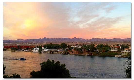
Bullhead City is located in Arizona's west-central Mohave County, on the east bank of the Colorado River near the juncture of Arizona, California and Nevada. It is the sister city to the popular gaming community of Laughlin, Nv.
Bullhead City serves as the economic hub and retail-shopping center for Western Mohave County and Southeastern Clark County, Nevada. More than five million people travel through Bullhead City annually. The year-round sunshine makes it perfect for families, retirees and vacationers - whether they are looking to escape the winter cold or want to enjoy the area's vast summer water recreation opportunities.
Originally established in the 1940s as the headquarters for the construction of Davis Dam, which impounds Lake Mohave in the Lake Mead National Recreation Area, Bullhead City has evolved into a year-round vacation community.
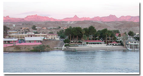
Tourism is a primary economic activity centered on the Laughlin resort/gaming industry. Visitors enjoy area water sports and golf. Also popular is trophy fishing for bass, trout, and other species in the Colorado River between Davis Dam and Parker Dam and on the 67-mile long Lake Mohave.
Population / Elevation
- 39,998 people
- 540 feet above sea level
Weather / Climate
Bullhead City has a classic low desert climate with extremely low relative humidity and very high summer temperatures. On the average, it receives about seven inches of precipitation a year. Stores, shops, restaurants, theaters and homes are air-conditioned much of the year.
Although most of the county is designated as desert, nearly 190 square miles is water, making water sports a favorite among residents and visitors alike. The average daily high temperature in November is 74 degrees. The average daily high temperature annually is a beautiful 88 degrees.
| Bullhead City, Arizona - Monthly Climate Normals | |||||||||||||
| Year | Jan. | Feb. | Mar | Apr. | May | Jun. | Jul. | Aug. | Sep | Oct. | Nov. | Dec. | |
| High °F | 88.5 | 65.0 | 71.1 | 78.4 | 88.0 | 97.0 | 107.3 | 111.8 | 109.8 | 102.8 | 90.6 | 74.6 | 65.1 |
| Low °F | 59.5 | 43.0 | 46.3 | 49.9 | 56.3 | 64.9 | 72.8 | 78.9 | 79.1 | 71.4 | 59.3 | 49.1 | 42.3 |
| Avg °F | 74.0 | 54.0 | 58.7 | 63.7 | 72.2 | 80.1 | 90.0 | 95.6 | 94.5 | 87.1 | 75.0 | 61.9 | 53.7 |
| Rain " | 7.02 | 1.21 | 1.18 | 1.14 | 0.19 | 0.11 | 0.01 | 0.38 | 0.74 | 0.45 | 0.43 | 0.53 | 0.66 |
Things To Do
Water sports on the Colorado River and Lake Mohave, hiking, off-road vehicle sports, hunting, exploring ghost towns, rockhounding and prospecting are just a few of the recreational activities available in the neighboring desert around Bullhead City. Gambling in Laughlin, across the river, is also a major attraction of the area.
The Colorado River Recreation Area extends from Yuma, Arizona to Lake Powell, about 650 miles. It offers boating, fishing, hunting and other water sports. There are almost 95 miles of navigable water to use for your enjoyment between Blythe and Imperial Dam in Yuma.
Hotels/Motels
There are hotels and motels in Bullhead City, with something for every taste and price range. For more information, click here.
Camping & RV Parks
Bullhead City has 9 mobile home parks and 21 RV parks, which are all near capacity from November through May.
- Katherine Landing Mohave County Parks - Davis Camp
- Backcountry camping: Along the shores of Lake Mohave and along designated sites on unpaved roads.
For more information, contact:
- Bullhead Area Chamber of Commerce
251 State Route 95
Bullhead City, AZ 86429
Tel. 928-754-4121
Resources & Nearby Attractions
Resources
Cities & Towns
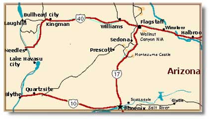
- Boulder City, Nevada: 70 miles north.
- Blythe, California: 70 miles south.
- Henderson, Nevada: 84 miles north.
- Las Vegas, Nevada:: 94 miles north.
- Laughlin Nevada: 2 miles west.
- Oatman, Arizona: 28 miles east.
- Chloride, Arizona: 41 miles northeast.
- Needles, California: 30 miles south.
- Quartzsite, Arizona: 65 miles south.
Parks & Monuments
- Death Valley National Park: 172 miles west.
- Mojave National Preserve: 63 miles west.
Wilderness & Recreation Areas
- Lake Mead National Recreation Area: 70 miles north.
- Lake Mohave: 20 miles north.
- Mojave National Preserve: The Desert Protection Act created the 1.4 million-acre Mojave National Preserve in the heart of California's Mojave Desert.
- Big Bend State Recreation Area: The state of Nevada preserves this area along the banks of the Colorado River south of Laughlin.
- Dead Mountains Wilderness Area: 48, 850 acres in the eastern Mojave Desert (BLM).
- Havasu National Wildlife Refuge: Created for waterfowl, this is a wintering habitat for snow goose and other waterfowl.
Historic & Points of Interest
- Colorado River Nature Center (CRNC): 500 acres located along the Colorado River south of Bullhead City.
- Oatman: Arizona town reenacts the Old West with staged gunfights in the middle of town.
- Katherine Mine: Katherine's Landing takes its name from the decaying Katherine Mine, located northeast of the current marina.
- Davis Dam: Constructed by the Bureau of Reclamation downstream from Hoover Dam, it impounds Lake Mohave.
- Lake Havasu: 50 miles south.
- Fort Mohave Indian Reservation: 41,884-acre home of the Mohave people, noted for their basketry and beadwork.
Related DesertUSA Pages
- How to Turn Your Smartphone into a Survival Tool
- 26 Tips for Surviving in the Desert
- Your GPS Navigation Systems
May Get You Killed
- 7 Smartphone Apps to Improve Your Camping Experience
- Desert Survival Skills
- How to Keep Ice Cold in the Desert
- Desert Rocks, Minerals & Geology Index
- Preparing an Emergency Survival Kit
- Get the Best Hotel and Motel Rates
Share this page on Facebook:
The Desert Environment
The North American Deserts
Desert Geological Terms


