Twentynine Palms, California
Mojave Desert and Joshua Tree National Park

Murals on the walls of the local businesses
The city of Twentynine Palms is in the middle of the Mojave Desert between Los Angeles and the Colorado River. The city was incorporated on November 23, 1987, and encompasses 58 square miles (larger than the city of San Francisco) and has grown from a population of 11,000 to more than 26,000. The city is the home of Joshua Tree National Park Headquarters and Oasis Visitor Center as well as a thriving artistic community.
Its beautiful surroundings make it a natural location for artists of all types. Joshua Tree National Park is one of the best places in the world to go stargazing. Twentynine Palms is proud of its dark night sky – residents and visitors are still able to see constellations and planets clearly.
About five miles from the main gate of the Marine Corps Air Ground Combat Center lies the main business district of Twentynine Palms. More businesses are developing in other locations around the growing city, which also serves as a gateway to the Mojave National Preserve, Mojave Desert Wilderness Areas, and other desert destinations.
Population / Elevation
26,848 / 2,000 - 2,500 feet above sea level
Weather / Climate
| Twentynine Palms, California - Monthly Climate Normals | |||||||||||||
| Year | Jan | Feb | Mar | Apr | May | Jun | Jul | Aug | Sep | Oct | Nov | Dec | |
| High °F | 87 | 69 | 73 | 77 | 84 | 93 | 102 | 107 | 105 | 100 | 90 | 78 | 69 |
| Low °F | 58 | 43 | 46 | 49 | 53 | 60 | 68 | 75 | 74 | 69 | 60 | 50 | 43 |
| Average °F | 73 | 56 | 60 | 63 | 68 | 76 | 85 | 91 | 90 | 84 | 75 | 64 | 56 |
| Rain | 6.51 | 1.0 | 1.0 | .81 | .23 | .09 | .02 | .35 | .67 | .44 | .31 | .69 | .86 |
History
Twentynine Palms derives its name from the life-giving waters of the lush oasis where 29 native California Fan Palms grew along the Pinto Mountain fault. More than 8,000 years ago, this area was occupied by the prehistoric Pinto culture. By the time Col. Henry Washington surveyed the region in 1855, the Cahuilla, Chemuevi, Serrano and Paiute had all frequented the oasis in their seasonal migrations. By the late 1800s, prospectors bivouacked here while seeking their fortunes in nearby gold camps, the most famous of which was the Dirty Sock Camp.
In 1910, Bill and Frances Keys, among the first pioneer homesteaders, settled at the Desert Queen Ranch in what is now Joshua Tree National Park. Dr. James B. Luckie is credited with populating the community after World War I ended in 1918, by sending veterans suffering from the effects of mustard gas here for the pure, healing desert air. This Pasadena doctor became a prominent citizen and a founding father of the city.
One WWI veteran, William Campbell, arrived with his wife Elizabeth in 1924 and began homesteading 160 acres off Joe Davis Road where they built a home of native stone, now a bed and breakfast called Roughly Manor at Campbell Branch. Aligned with the Southwest Museum of Los Angeles, the Campbells discovered thousands of archaeological sites and donated land for the first schoolhouse here, and for Luckie Park.
In 1952, the U.S. Defense Department established a marine base north of the oasis for glider training. Now known as the U.S. Marine Corps Air Ground Combat Center, this vast area of the Mojave Desert encompasses the world's largest marine base, housing 18-20,000 military personnel.
The city of Twentynine Palms was incorporated March 23, 1987.
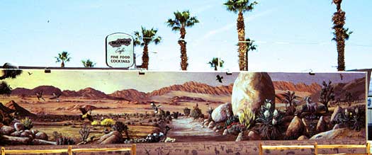
One of the many murals painted on the sides of buildings.
Accommodations
Camping
Joshua Tree National Park
9 campgrounds within the park -- Online reservations
Things To Do
Annual Hilltoppers Motorcycle Wild West Grand Prix - Late Spring/Early Summer
The annual Hilltoppers Motorcycle Wild West Grand Prix offers motorcycle-racing fun for the whole family. All races are held at the 29 Palms Motorsports Arena located three miles east of town on 29 Palms Highway.
The AMA (American Motorcycle Association) sanctioned, FMF Big 6 Grand Prix series is comprised of 6 races, each held in different communities and hosted by a District 37 Motorcycle Club. The 29 Palms Grand Prix is the third race of the Big 6 Grand Prix series. Twentynine Palms has hosted the Hilltoppers event since 1996.
There are different classes in which riders participate including Kids and Pee-Wee racing, Vintage, Classic, and a Pro Team race with a minimum $3000 purse. Over 1300 riders participate. Races begin at 8:00 a.m. on two days; grandstands are available for spectator viewing. Vendors and food booths are open both days.
Gate fee is typically $10.00 per person, per day or $15.00 per person for the weekend. AMA, D-37 cardholders, seniors and military I.D. holders typically pay $5.00 per day or $10 for the weekend. Children aged twelve and under are free. Overnight camping is allowed. This event is held annually in the late spring/early summer. Please contact the Twentynine Palms Chamber of Commerce for details.
National Park Art Festival - April
Come visit the Annual Art Festival at the Joshua Tree National Park's visitor center in Twentynine Palms. You'll have the pleasure of seeing the work of more than twenty artists. Love and respect for Joshua Tree National Park is the common bond between these artists; you can't escape the feelings of camaraderie at this festival! Each artist has work on exhibit and for sale and enjoys sharing their very personal interpretation of Joshua Tree National Park with you.
Painting, sculpture, photography, ceramics, and jewelry are some of the media included in the Art Festival. Joshua Tree National Park Association, sponsor of the Art Festival, is a nonprofit organization that provides support and assistance to the Park's interpretive, educational and scientific programs. Open to the public, there is no fee to attend the Art Festival. Begun in 1992, the festival is held on a consecutive Friday, Saturday and Sunday in early April each year
Joshua Tree Music Festival - Mid-May
The biannual Joshua Tree Music Festival is a three day event held at Joshua Tree National Park in May and then again in October. This annual festival attracts music lovers and musicians from around the world. For band lineup, pricing and other information, please visit the website at http://www.joshuatreemusicfestival.com.
Street Fair & Car Show - 1st Weekend in June
Don’t miss the annual Twentynine Palms Street Fair and Car Show! This extravaganza is held on the Twentynine Palms Highway (State Route 62) in downtown Twentynine Palms the first weekend in June. Vendors line the street and downtown merchants extend business hours for your shopping and dining pleasure. Enter your own classic car or help us elect winners in a "People’s Choice" contest. Have a snowcone or visit an old fashioned soda fountain. Get an airbrush tattoo or face paint for the kids. You can even test wireless internet services or check out new wireless phones! Local radio station Z107.7 provides music with a live, remote broadcast. Join us for hometown summer fun. Contact the Chamber of Commerce at 760.366.3723 for vendor applications, car show entry forms or more information, or check their website here: http://joshuatreechamber.org.
Morongo Basin Orchid Festival - October
Just in time for the orchid blooms in October, this festival is a fundraising event for charity programs throughout the Morongo Basin. There is food, entertainment, flower education and plenty of fun to be had at this event. For more information, please contact Gubler Orchids at (760) 364-2282 or visit their website at http://www.gublers.com.
Pioneer Days - October
What we know as Pioneer Days began in 1937 with a community May Day affair in which all school children participated. The grammar school furnished a rhythm band, and a queen and her court were chosen from the high school.
The hit of the day was the comedy provided by a group of townsmen who dressed up as girls and clowned through a May dance of their own. Their May Pole was a crooked tree branch stuck in a nail keg with dangling carpet rags for streamers. A well-attended dance was held that night at the tennis courts. In all, the celebrations netted $28.
A rodeo was held the next day. Events included a boot race, package race, rescue race, potato race, relay race, musical chairs events, a take race, and a pony express race. The afternoon was climaxed by a beef barbecue and ice cream. A soft drink concession was opened, and Twentynine Palms Produce furnished free coffee.
1938 found the celebration renamed Pioneer May Day, and in 1940 a parade was added. In 1941 the Chamber of Commerce took over the arrangements, changing the date to April. Rationing during World War II postponed further yearly events until 1946 when the celebration was once again held in May. In 1948 the Pioneer Day events moved permanently to October and Western days were adopted as the fixed theme.
Three-day celebrations started in 1950, and Pioneer Days that year featured an ever increasing number of parade entries, booths, and exhibitions. As the town more than tripled since the 1950s, Pioneer Day's activities grew with the population, increasing in scope and variety to become an annual event that both newcomers, as well as old-timers, look forward to with interest each year.
Today, Pioneer Days encompasses nearly a dozen separate events including a wonderful hometown parade, a children’s carnival, an Honorary Judge & Sheriff contest, an arm wrestling tournament, rodeo, carnival, children’s costume contest, charity walk, pancake breakfast, chili dinner, a beard and leg contest (for men!), concerts, dances and the unique and wacky Outhouse Races. Most events are free to spectators, courtesy of sponsorships by local merchants. Enjoy family fun in a safe, casual environment! Contact the Twentynine Palms Chamber of Commerce at 760-367-3445 or www.29chamber.com for more information and a schedule of events.
Open Studio Art Tours - Late October/Early November
Morongo Basin Open Studio Art Tours is held each year in late October and very early November. The tours include several venues of theatre, art exhibitions and music as well as tours of artists' studios.
For two weekends and the days and nights in between, the Morongo Basin comes alive with the sights and sounds of art – in studios and galleries and from performance venues throughout the region including the communities of Morongo Valley, Joshua Tree, Yucca Valley, Twentynine Palms, Landers, Pioneer Town and Wonder Valley.
Programs and Studio Tour Information handbooks are available free at area Chambers of Commerce and the California Welcome Center.
Weed Show- 1st Weekend in November
The Weed Show is one of Twentynine Palms’ oldest and most unique artistic traditions. This annual display, now in its seventh decade, features artistic arrangements of indigenous desert vegetation as well as found objects both natural and man-made – a desert rendition of the traditional concept of floral display. Each show follows a specific theme. Entries are judged on subject matter, use of desert vegetation, use of accessories, artistic composition and originality. Awards are granted in nine categories, with a “People’s Choice” award to be decided by visitors to the exhibition.
The show’s roots go back to July 1940, when the Women’s Club of Twentynine Palms invited Pasadena printmaker Mildred Bryant Brooks to deliver a lecture on “The Art of Etching.” Legend has it that the local ladies, ever mindful of etiquette, were deeply embarrassed by the lack of fresh flowers with which to decorate the podium and honor their esteemed guest. The ladies of the club expressed their apologies to Brooks, who is then reputed to have said, “Why do you need fresh flowers when you have so many beautiful weeds?” The ladies then dispatched two of their members to gather sun dried desert flora from the grounds of the Twentynine Palms Inn, which they brought back for Brooks to arrange.
The Weed Show made its official debut the following year in 1941. Initially held in private homes, its popularity soon grew until it became a bona fide community event. After the Women’s Club disbanded in 1976, sponsorship of the show passed to the Twentynine Palms Gardening Club; then when the Gardening Club disbanded, the Historical Society revived the show, which has been going strong ever since.
It is one of Twentynine Palms' most characteristic events. The Weed Show highlights the beauty of the local flora and the skill of our town’s artisans, and the history and culture of Twentynine Palms itself. For more information contact the 29 Palms Historical Society.
Resources & Nearby Attractions
Resources
- Related Books & Gifts - Trading Post
- Joshua Tree (Yucca brevifoilia)
- Inselbergs: The Unique Rock Formations at Joshua Tree National Park
- Rock Climbing at Joshua Tree National Park
- Mountain Bike Trails in Joshua Tree National Park
- Old Dale Road/Gold Crown Road 4WD Expedition
- Sheer Fear: Desert Rock Climbing at Joshua Tree National Park
- Desert Fan Palm Oases
Cities & Towns
- Yucca Valley, California: 26 miles west.
- Victorville, California: 96 miles northwest.
- Barstow, California: 105 miles north.
- Palm Spings, California: 54 miles south.
- Quartzsite Az 85 miles east
Parks & Monuments
Wilderness & Recreation Areas
- Sunfair Dry Lake: Recreation area for all-terrain vehicles (ATV) on the site of an ancient lake.
- Mojave National Preserve: The Desert Protection Act created the 1.4 million-acre Mojave National Preserve in the heart of the Mojave Desert.
- Big Morongo Canyon Wildlife Preserve: Used by Native Americans as an easy route between low and high deserts, these 3,900 acres are a world renowned small bird sanctuary. (BLM)
- Johnson Valley Off-Highway Vehicle Area: A varied landscape for off-highway vehicles, punctuated by steep red rocky mountains, rolling hills, open valleys, dry lake beds and sandy washes. (BLM)
- Trilobite Wilderness Area: 31,160 acres of Desert Wilderness Area containing trilobite fossils. (BLM)
- Sheephole Valley Wilderness Area: 174,800 acres of Desert Wilderness Area. (BLM)
- Cleghorn Lakes Wilderness Area: 33,980 acres of Desert Wilderness Area. (BLM)
- Cadiz Dunes Wilderness Area: 39,740 acres of Desert Wilderness Area. The Cadiz Sand Dunes, with their unique flora and fauna, are the focal point of this wilderness. (BLM)
Historic & Points of Interest
- Joshua Tree & Southern Railroad Museum: Model railroad station houses memorabilia and Live Steam Club. 760-366-8030.
- 29 Palms Historical Society Museum: Exhibits of artifacts and memorabilia displayed in the original schoolhouse. 760-367-2366.
- 29 Palms Art Gallery: Exhibits local and out-of area artists in a genuine adobe structure. 760-367-7819.
- Indian Burial Ground: At least 60 Chemuevi and Serrano are buried here, including the last chief, Jim Pine.
- Oasis of Mara: The original 29 Palms, now part of Joshua Tree NP headquarters.
- Murals of Twentynine Palms: Huge historical murals are painted on buildings throughout the city.
- Marine Corps Air Combat Training Center: The world's largest marine base occupies 932 square miles north of the city.
Related DesertUSA Pages
- How to Turn Your Smartphone into a Survival Tool
- 26 Tips for Surviving in the Desert
- Death by GPS
- 7 Smartphone Apps to Improve Your Camping Experience
- Maps Parks and More
- Desert Survival Skills
- How to Keep Ice Cold in the Desert
- Desert Rocks, Minerals & Geology Index
- Preparing an Emergency Survival Kit
Share this page on Facebook:
The Desert Environment
The North American Deserts
Desert Geological Terms


