Julian, California
Historic Gold Mining Town and Apple Festival
Julian is a small mountain community in Southern California located at the intersection of California highways 78 and 79, about 50 miles northeast of San Diego. This historic gold-mining town is nestled among oak and pine forests between the north end of the Cuyamaca Range and the south slope of Volcan Mountain.
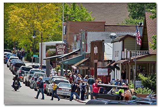
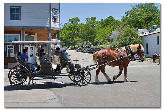
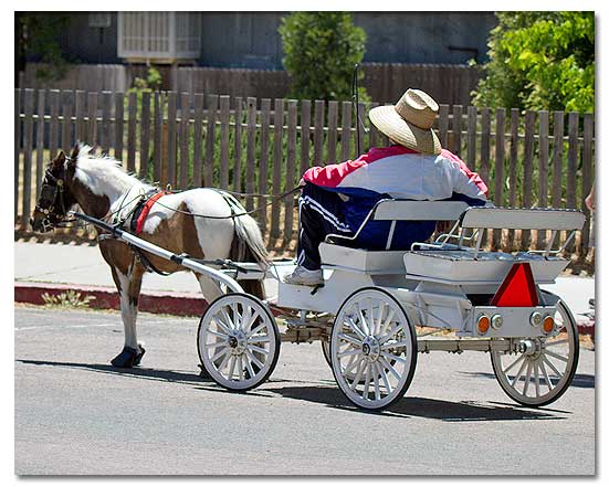
The entire township of Julian is a Designated Historical District. Its image as an early California frontier town with pioneer store fronts, historic sites and guided tours of Eagle and High Peak Mines accounts for much of its modern appeal. Tourism is Julian's largest industry, followed by cattle raising.
Julian is also unique among Southern California communities for its cold-winter climate, ideal for growing apples. All Julian apples are sold locally as apple pies, apple cider or whole fruit. In October, 10,000 apple pies a week are baked in Julian, when Southern California tourists flock here for the fall colors, cool breezes, frontier atmosphere and its famous Apple Festival.
Julian began as a California mining camp when A.E. (Fred) Coleman discovered placer gold at Coleman Creek in 1869. Drue Bailey founded Julian City in 1870, naming it after his cousin Mike Julian. Bailey and Julian were cousins and ex-confederate soldiers who had left Georgia after the Civil War for the California gold fields.
By the summer of 1872, there were 50 houses, 3 hotels, 4 stores, 2 restaurants, 1 schoolhouse and the "usual number of saloons" to service an an estimated 300 miners working in the area. Numerous hard rock mines were established in 1879 in the Julian and Banner area yielded an estimated $4 to $5 million dollars in gold ore.
Unlike other such camps, Julian survived after the mines played out because of its climate, rich soil and proximity to San Diego. Julian's first newspaper, The Julian Sentinel, began publishing in 1887. Since James Madison first brought the first apple trees to Julian in the early 1870s, Julian apples have won many blue ribbons at places like the Chicago World's Fair of 1893, the St. Louis Fair and the San Francisco World's Fair of 1915. The first Julian apple celebration was held in 1909 , but wasn't followed by another until 1949.
Population / Elevation
- 500 municipal / 4,000 area
- 4, 235 feet above sea level
Weather / Climate
Julian has four moderate but distinct seasons with average annual precipitation of 30 inches. Cool springs and falls contrast with hot days and cool nights during summer and occasional winter snowfall from December to March. Various climates, from desert to high mountains, exist within 25 miles of Julian.
| Julian, California - Monthly Climate Normals | |||||||||||||
| Year | Jan | Feb | Mar | Apr | May | Jun | Jul | Aug | Sep | Oct | Nov | Dec | |
| High °F | 70.8 |
55.6 | 58.2 | 59.3 | 64.8 |
71.3 | 81.4 | 90.1 | 89.6 | 84.6 | 74.2 | 63.4 | 57.4 |
| Low °F | 41.7 |
34.5 | 34.7 | 34.8 | 37.0 | 40.6 | 45.8 | 53.0 | 53.7 | 49.3 | 49.3 | 38.1 | 35.6 |
| Average °F | 56.3 | 45.1 | 46.5 | 47.1 | 50.1 | 56.0 | 63.6 | 71.9 | 71.7 | 66.7 | 61.8 | 50.8 | 46.5 |
| Rain | 25.89 |
4.68 | 4.09 | 4.51 | 2.41 | 0.97 | 0.14 | 0.39 | 0.74 | 0.83 | 0.98 | 2.86 | 3.27 |
San Diego Backcountry Recreation Map
Lodging
There are Bed And Breakfast and Inns in Julian, with something for every taste and price range.
Camping / RV Parks
There are 9 campgrounds /RV parks in and around Julian . For a complete list contact:
- Julian Chamber of Commerce
P.O. Box 1866 ~ Julian, CA 92036
Tel: 760-765-1857 ~ Fax: 760-765-2544
Things To Do
Events Calendar
- January: Dawn Kirk Crafters Arts & Crafts Show
- February: Vintage Cook Book Fair and B&B Guild Taste of Julian
- March: Volcan Mountain Preserve Hike
- April: B&B Guild Birdwatcher Lecture and Bird Tour
- May: Annual Fat Tire Bike Festival
- June: B&B Guild Summer Nights Kick-Off
- July: Julian Community Fourth of July Parade
- August: The Dawn Kirk Crafters Weed & Craft Show
- September: Julian celebrates the end of summer with music
- October: Apple Days in Julian
- November: Every Sunday : 'Music at the Marketplace
- December: Town Hall Market & Arts
- February: Vintage Cook Book Fair and B&B Guild Taste of Julian
Resources & Nearby Attractions
Resources
Cities & Towns
- Borrego Springs, California: 30 miles east.
- Indio, California: 91 miles northeast.
- Brawley, California: 60 miles east.
- El Centro, California: 100 miles southeast.
- Warner Springs, California: 25 miles north.
- San Diego, California: 50 miles west.
Parks & Monuments
- Anza-Borrego Desert State Park: 12 miles east.
- Joshua Tree National Park: 121 miles northeast .
- Agua Caliente/Vallecito Regional Parks: 38 miles east.
- Cuyamaca Rancho State Park: 10 miles south.
- Palomar Mountain State Park: 75 miles northwest.
- San Pasqual Battlefield State Historic Park: 30 miles west.
- William Heise County Park: Information 694-3049; reservations 565-3600.
Wilderness & Recreation Areas
- Ocotillo Wells Vehicular Recreation Area: 30 miles east.
- Imperial Sand Dunes: 90 miles east.
- Salton Sea National Wildlife Refuge: 80 miles east.
- Salton Sea State Recreation Area: 110 miles east.
- Superstition Mountain Off-Highway Vehicle Area: 75 miles miles east.
Historic & Points of Interest
- Julian Pioneer Museum: 760 765-0227
- Eagle and High Peak Mine: 760 765-0036
- Apple Lane Orchard:760 765-2645
- Volcan Mountain Nature Preserve:
- California Wolf Center 619 234 9653
Related DesertUSA Pages
- How to Turn Your Smartphone into a Survival Tool
- 26 Tips for Surviving in the Desert
- Your GPS Navigation Systems
May Get You Killed
- 7 Smartphone Apps to Improve Your Camping Experience
- Desert Survival Skills
- Successful Search & Rescue Missions with Happy Endings
- How to Keep Ice Cold in the Desert
- Desert
Survival Tips for Horse and Rider
- Preparing
an Emergency Survival Kit
Share this page on Facebook:
The Desert Environment
The North American Deserts
Desert Geological Terms


Click here to see current desert temperatures!