4 X 4 Trails
Anza-Borrego Desert State Park
Anza-Borrego Desert State Park offers enough variety to please just about anyone. There are more than 500 miles of roads in the park. There are routes up rocky hills, through deep sand, along scenic streams and down steep hills. Both primitive jeep roads and paved roads are also open to bicycles, so be careful. Drivers must stay on roadways at all times and may not venture off the trails.
- All vehicles must be highway legal.
- You must have a driver's license to drive in the state park; underaged, unlicensed drivers may operate vehicles in Ocotillo Wells State Vehicular Recreation Area under the supervision of a licensed driver.
4 X 4 Route Descriptions

1. Split Mountain
Ride right through the split and enjoy the view from inside a mountain. This is a sandy road with a fairly gentle grade. Park at the mouth of the Fish Creek wash along Split Mountain Road. Ride in 4 miles to the Wind Caves trailhead. You can enjoy spectacular geologic formations at the Wind Caves as a unique side trip, if you are willing to leave your car or truck and walk.
2. Blair Valley
The Blair Valley area offers fairly level terrain and a good firm road most of the time. Drive into one of the trailheads and take a short walk to see the morteros or pictographs. (From highway S2 to Mortero Trail 3.8 miles, or 5.2 miles to Pictograph Trail.)
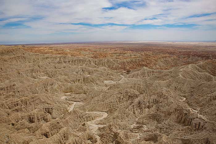
View from Font's Point
3. Borrego Badlands Font's Point
Font's Point may be the best place in North America to view sediments of the Pliocene and Pleistocene Epochs. But the visitor has to stretch their imagination to visualize a landscape devoid of cacti, ocotillo and creosote bush. During the Pliocene Epoch, (1.6-5 million years ago), Anza-Borrego was a receiving basin for the ancestral Colorado River while it carved out the Grand Canyon. Sandy road, 4 wheel drive recommended.

Arroyo Tapiado (mud caves)
4. Carrizo Badlands
Park at the Carrizo Overlook on Highway S2 and enjoy the ride down Canyon Sin Nombre. Explore Carrizo Creek or Vallecito Creek or make a loop using Arroyo Tapiado (mud caves) and Arroyo Seco del Diablo. Video on area.
5. Coyote Canyon
Coyote Canyon bisects the Bucksnort and Coyote Mountains, where Juan Bautista De Anza's original route is marked by the First Child Monument, Santa Catarina and El Vado (Anza Camp). Further up Coyote Canyon, bighorn sheep, as well as wild horses and coyotes, grace the rugged terrain. Roads and trails here follow historic routes of the Native American Cahuilla. Sandy road with rocks, 4 wheel drive recomended. Video Coyote Canyon to Lower Willows.
6. Grapevine Canyon
Here you can find a long downhill ride if you start down the Jasper Trail near Ranchita on the western boundary of the park. Stay on Grapevine Canyon road to avoid hills and rough riding. You'll enjoy shady trees and springs, but watch for bike traffic. Yaqui Well is a good spot to rest and watch birds and perhaps other desert critters.
7. Pinyon Mountain
Starting at Pinyon Mountain at about 4000 feet, you'll see the incredible diversity of this area as you work your way down to sea level. The 28-mile route down toward Split Mountain offers some deep sand and a scary drop-off. This road is one way and not for a new off-road driver.
8. Borrego Mountain Area
You'll find several interesting loop routes using Buttes Pass Road, Goat Trail and San Felipe wash. These routes are all in washes which may mean deep sand at times. Check current conditions before venturing out.
The Ocotillo Wells State Vehicular Recreation Area, operated by California State Parks, contains over 80,000 acres of magnificent desert open for off-road exploration and recreation. To the south and east, large tracts of BLM land (U.S. Department of the Interior, Bureau of Land Management) are also open to off-highway vehicles. The western boundary and part of the northern boundary connect with the half-million acre Anza-Borrego Desert State Park, which is closed to off-road recreation, but open to exploration by highway-legal vehicles along established primitive roads.
Riding the paved roads. There are a number of highways that criss-cross this huge state park and require no fee to travel.
Visitor Center | Points of Interest | Where to Stay | Maps and Weather | Videos
More Things to Do in the Park.

Related DesertUSA Pages
- How to Turn Your Smartphone into a Survival Tool
- 26 Tips for Surviving in the Desert
- Your GPS Navigation Systems
May Get You Killed
- 7 Smartphone Apps to Improve Your Camping Experience
- Desert Survival Skills
- Successful Search & Rescue Missions with Happy Endings
- How to Keep Ice Cold in the Desert
- Desert
Survival Tips for Horse and Rider
- Preparing
an Emergency Survival Kit
Share this page on Facebook:
The Desert Environment
The North American Deserts
Desert Geological Terms


Click here to see current desert temperatures!