Newspaper Rock
National Historical Site - Indian Creek State Park

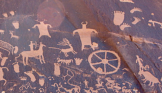
Newspaper Rock is a petroglyph panel etched in sandstone that records perhaps 2,000 years of human activity in the area. Etched into the desert varnish are more than 650 symbols representing the Fremont, Anasazi, Navajo and Anglo cultures.
The exact nature of these symbols’ meanings is still not clearly understood. But they are typical of many sites throughout the U.S. in their use of universal symbols, be it graffiti or a true "newspaper" recording events of the times and earlier. The Navajo term for the rock is "Tse' Hone'", or "Rock that tells a Story."

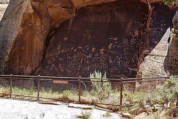

The area is right next to Utah Route 211, 24 miles northwest of Monticello on the main road into the Needles section of Canyonlands National Park. It is usually bypassed by travelers hurrying elsewhere. They are missing one of the finest displays of Indian rock art to be found anywhere in the U.S. This is also one of the few petroglyph sites that is easily accessible and can be viewed and photographed at close range.
Made a state historic monument of Utah in 1961, it was added to the National Register of Historic Places as Indian Creek State Park in 1976.
General Information
Rates & Fees
Entrance: None
Seasons / Hours
Open year round, 24 hours a day.
BLM Monticello Utah Field Office
435-587-1500
Hotels/Motels
There are hotels and motels in Monticello, Blanding and Moab, Utah with something for every taste and price range.
There is no camping in this area. The old campground across from the Newspaper Rock is closed. Camping there is now illegal.
Rresources & Nearby Attractions
Cities & Towns
- Moab, Utah: 50 miles north.
- Blanding , Utah: 48 miles south.
- Monticello , Utah: 24 miles southeast.
- Cortez, Colorado: 84 miles east.
Parks & Monuments
- Canyonlands National Park (Needles District): 23 miles northwest.
- Arches National Park: 61 miles north.
- Hovenweep National Monument: 115 miles east.
- Natural Bridges National Monument: 88 miles southwest.
- Mesa Verde National Park: 94 miles east.
- Goosenecks State Park: 85 miles south.
- Edge of the Cedars State Park: 48 miles south.
Recreation & Wilderness Areas
- Glen Canyon NRA (Bullfrog Marina): 153 miles southwest.
- Glen Canyon NRA (Hite Marina): 123 miles southwest.
- Manti-La Sal National Forest: Adjoins the park.
Historic & Points of Interest
- Butler Wash Ruins Overlook: 57 miles southwest.
- Mule Canyon Ruins: 63 miles southwest.
Related DesertUSA Pages
- How to Turn Your Smartphone into a Survival Tool
- 26 Tips for Surviving in the Desert
- Death by GPS
- 7 Smartphone Apps to Improve Your Camping Experience
- Maps Parks and More
- Desert Survival Skills
- How to Keep Ice Cold in the Desert
- Desert Rocks, Minerals & Geology Index
- Preparing an Emergency Survival Kit
Share this page on Facebook:
The Desert Environment
The North American Deserts
Desert Geological Terms


