Arches National Park
Map and Climate
Overview | Description | Things To Do | Lodging/Camping | Nearby | Video
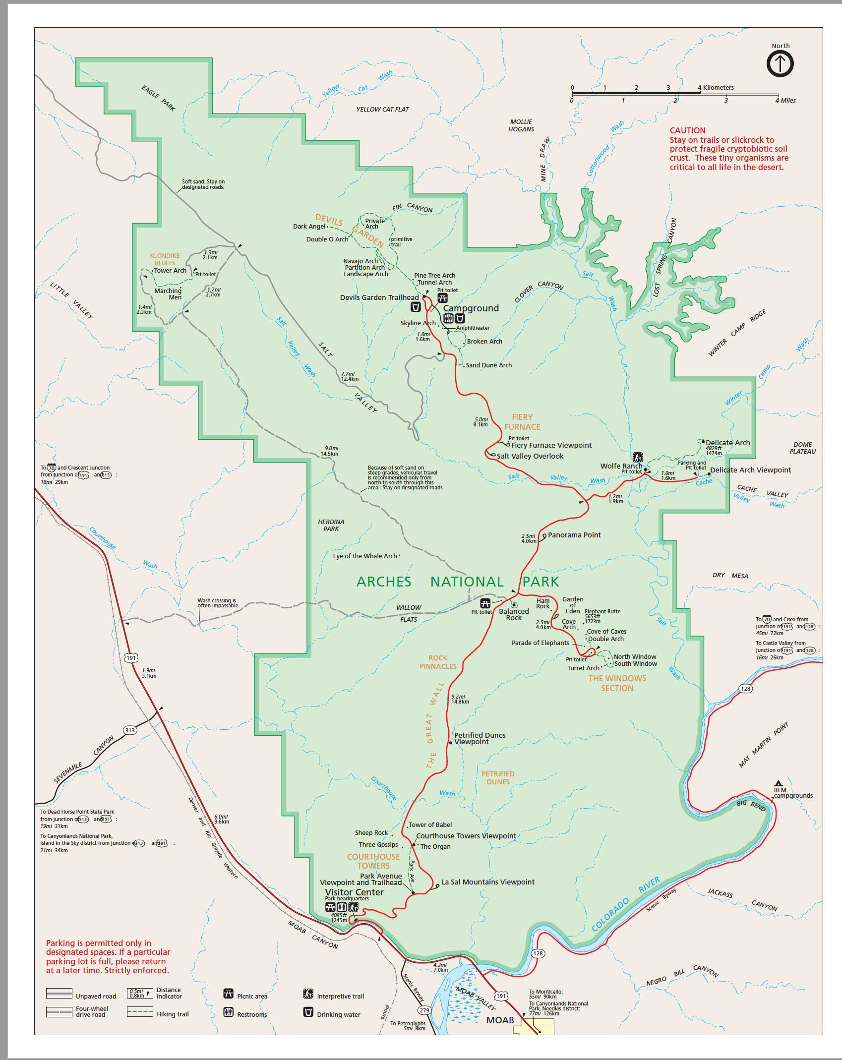
Map In a PDF format Arches National Park - PDF
Arches National Park is located on the Colorado Plateau of eastern Utah in the northeast corner of what is called Canyon Country. It runs about 15 miles north-to-south and about 10 miles east-to-west, encompassing 114 square miles ( 73,379 acres).
The Colorado River creates the southern boundary of Arches National Park. On the opposite bank is the Moab Valley and the town of Moab. To the east, across the Colorado River, the La Sal Mountains rise to over 12,000 feet. The park is adjoined on the west by the Moab Canyon. Salt Valley runs through the park from northwest to southeast.

Climate
In summer, June through September, temperatures may exceed 100 degrees F; in winter, December through February, temperatures often drop below 32 degrees F. Temperatures may range 50 degrees in a 24-hour period. Dress accordingly. Very dry! Carry drinking water at all times.
![]()
Getting There
Transportation
Air
Major airlines fly into Salt Lake City, Utah (5 hours by car) or Grand Junction, Colorado (2 hours by car). A commuter airline, Alpine Air, flies into the Canyonlands Airport, 15 miles from the park, and into Salt Lake City.
Bus
Greyhound Bus stops 50 miles northwest of the park in Green River, Utah.Train
Amtrak stops 40 miles northeast of the park in Thompson Springs, Utah. Rental vehicles and taxis can be arranged.
By Auto
Arches National Park entrance is 5 miles north of Moab, Utah on U.S. Route 191, 3 miles north of its junction with Utah Highway 128. From Interstate 70 traveling east, take U.S. Route 191 south from Crescent Junction, 30 miles south to the park. Traveling west on Interstate 70, take Utah 128 southwest from the Cisco exit, 48 miles to the park entrance.
Overview | Description | Things
To Do | Lodging/Camping | Nearby | Video
Arches National Park
P.O. Box 907
Moab, UT 84532
Phone: (435) 719-2299
Related DesertUSA Pages
- How to Turn Your Smartphone into a Survival Tool
- 26 Tips for Surviving in the Desert
- Death by GPS
- 7 Smartphone Apps to Improve Your Camping Experience
- Maps Parks and More
- Desert Survival Skills
- How to Keep Ice Cold in the Desert
- Desert Rocks, Minerals & Geology Index
- Preparing an Emergency Survival Kit
Share this page on Facebook:
The Desert Environment
The North American Deserts
Desert Geological Terms


