
Great Basin Desert
Largest Desert in the United States

Rt 50 in the Great Basin Desert
The Great Basin Desert, the largest U. S. desert, covers an arid expanse of about 190,000 square miles and is bordered by the Sierra Nevada Range on the west and the Rocky Mountains on the east, the Columbia Plateau to the north and the Mojave and Sonoran deserts to the south.
This is a cool or "cold desert" due to its more northern latitude, as well as higher elevations (at least 3,000 feet, but more commonly from 4,000 to 6,500 feet). Precipitation, generally 7-12 inches annually, is more evenly distributed throughout the year than in the other three North American deserts. Winter precipitation often falls as snow.
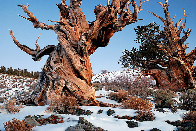
This is a long exposure taken after sunset in the Bristlecone Pine Forest of the White Mountains in California. This particular grove of bristlecones are the oldest living things on the planet, many of them are over 4000 years old and the oldest has been dated to over 4700 years.
Rick Goldwaser from Flagstaff, AZ, USA
Playas are a conspicuous part of this desert, due to its recent geological activity. (When small lakes dry up, they leave a salt crust or hardpan. The flat area of clay, silt, or sand encrusted with salt that forms is known as a playa.) In notable contrast to the other three deserts, Great Basin vegetation is low and homogeneous, often with a single dominant species of bush for miles. Typical shrubs are big sagebrush, blackbrush, shadscale, Mormon-tea and greasewood. There are only occasional yuccas and very few cactus.

The Colorado Plateau, centered in northeastern Arizona, and including the adjacent Four Corners region of Utah, Colorado and New Mexico, is sometimes included in the Great Basin Desert, sometimes considered a separate desert -- the Navajoan. The Plateau includes large barren areas, spectacular geological formations, more juniper and pinyon trees and generally higher elevations.


Bristlecone Pine
The limber and bristlecone pines are found at highest elevation 9,500 to 11,000 feet in the Snake Range of the Great Basin Desert. While both species are obviously hardy plants, bristlecone pines are the stuff of legend. True masters of longevity, they endure not centuries but millennia. A bristlecone pine found in this area was determined to be the world's oldest living thing: 4,950 years old.
More Deserts in the USA
Chihuahuan Desert | Mojave Desert | Sonoran Desert
Great Basin National Park
Nevada's U.S. Route 50
High Desert Oregon and Idaho Border
Other DesertUSA Resources
Desert Animal Survival
Surviving Summer in Death Valley
Desert Survival Primer for People
Desert Survival Kit


Share this page on Facebook:
The Desert Environment
The North American Deserts
Desert Geological Terms


