By Joe Zentner
Mesa Verde National Park, the site of some of the most spectacular and mysterious prehistoric ruins in all of the United States, lies about 35 miles west of Durango, Colorado, south of U. S. Highway 160, in the southwestern corner of the Centennial State. Heavily dissected, Mesa Verde ranges from 6000 to 8500 feet in elevation. The park encompasses an area of more than 52,000 acres. The mesa’s flat top and canyons support a woodland of pinyon pine, ponderosa pine, Utah juniper and gambel oak. Mesa Verde is located just south of the stately La Plata Mountains, which rise more than 13,000 feet in elevation and support a forest of aspen, spruce, fir and cottonwood trees.

During the first millennium, Mesa Verde – the Spanish term for “green table” – along with southeastern Utah became home to the Mesa Verdan branch of the storied Anasazi Puebloan people. The famed Chaco Canyon pueblos, to the south, became cultural center of the Chacoan branch. The more scattered pueblo villages, to the west, became the hallmark for the Kayenta branch. The Four Corners, where Utah, Colorado, Arizona and New Mexico join at a common point, is the heart of the Anasazi region, which is sometimes called the Athens of the prehistoric Southwest.
The Anasazi
The Anasazi (a Navajo word meaning “ancestors of our enemies”) cultural traditions began to emerge early in the first millennium, presumably from nomadic bands who hunted the game and gathered the wild plants of the Four Corners area.
The early Anasazi lived as pithouse village farmers along stream bottoms and mesa tops. They occupied lodges built of mud-plastered timber and brush constructed over shallow excavations in the ground. They raised corn, beans and squash—crops that originated well down in Mexico. They supplemented their farm produce with game (especially rabbits) and wild plants. They made pottery, following a technology that originated in Mexico. About 500 A. D., they replaced traditional spears and throwing sticks (sometimes called “atlatls”) with the bow and arrow, a much more efficient weapon that evidently originated somewhere to the north. They distinguished themselves by producing elaborate and finely woven basketry.

The later Anasazi, in the second half of the first millennium, began building their lodges and other structures, not over pits, but as contiguous rooms on the surface of the ground. In some instances, they built jacal-style walls, that is, walls of adjoining upright poles plastered with mud or adobe. They sometimes built pithouses that may have served, not as housing, but as chambers for clan social gatherings, crafts and ritual—prototypes for the ceremonial chambers called “kivas.” Late in the first millennium, the Anasazi began to build small cities – pueblos – of finely crafted walls of masonry. They would leave well-planned communities, innovative architecture, superb masonry and large circular semisubterranean “great kivas” as their collective signature. At the peak, as many as 100,000 Anasazi may have occupied the Four Corners region.
The Mesa Verdan Anasazi
Anasazi pithouse village farmers moved into Mesa Verde about the middle of the first millennium, settling primarily on the mesa tops.
Typically, they built their lodges over roughly square- or rectangular-shaped pits. They used crude wooden tools to excavate the pits and woven baskets to haul away excess soil. They set four main ponderosa pine timbers, one at each corner, to anchor the walls and support the roof. They divided the interior into a living room with a fire pit and an air deflector and an antechamber with storage bins. They farmed the mesa tops, hunted rabbits and deer, gathered wild plants, crafted pottery, used the bow and arrow and wove fine baskets.
About the middle of the 8th century, the Mesa Verdans, their population prospering and growing, began to give up their pithouses in favor of surface structures, building long rows of contiguous rooms with the jacal-style walls. Within another one to two centuries, they had become masters of masonry, building two- to three-story pueblos with 50 or more rooms. They cleared more of the mesa tops to open up new fields for their crops. They began to produce a more elaborately designed pottery.

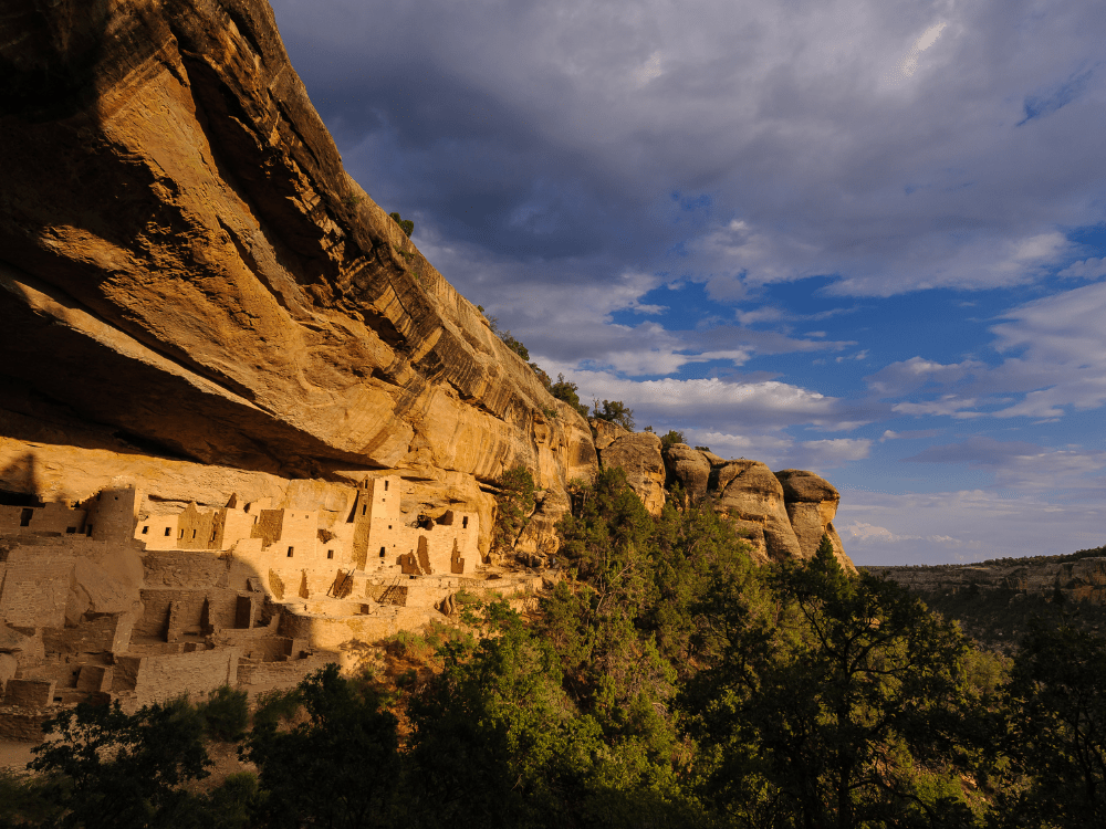
A century into the second millennium, the Mesa Verdans, now with a population of perhaps 5000, did a strange thing. For some mysterious reason, they began to abandon their pueblos on the mesa tops and construct new pueblos in the great canyon alcoves. Calling on all their skills for community planning, architecture and masonry, they built compact and defensible stone cities with many small rooms that were used for living, cooking, working and storage. In the midst of their new villages, they built, for the first time, multistory stone towers. In the natural courtyards of their communities, they built large underground kivas. They continued farming, hunting and gathering. They raised their craftsmanship to the level of art. The reason for the move from the mesa tops into the canyons? Possibly for defense. But against whom? No one knows. It is one of the great mysteries of Mesa Verde.
Two to three centuries into the second millennium, the Mesa Verdans did another strange thing. Like Anasazi across the region, they began to abandon their ancestral homeland. Family units, clans or possibly entire villages migrated to the southeast or south, where they built new pueblos or joined other Puebloan peoples, sometimes in very large and populous communities. What were the reasons for the migration? Possibly the threat of raiders, the onset of prolonged drought, the depletion of timber and other resources, the exhaustion of arable soil, the collapse of their religious and political infrastructure, the lure of other pueblos’ different religious concepts, the promise of greater resources and a better life, or some combination of reasons, but no one knows for sure. The abandonment is perhaps the greatest mystery of Mesa Verde.

Modern-Day Discovery
Though they named the landmark, Spaniards probably did not discover Mesa Verde’s remarkable ruins. In 1859, the first published report of a visit to the region came when J. S. Newberry, a geologist accompanying a group that was charting rail routes across southern Colorado, wrote that he had climbed to the top of the mesa to enjoy the spectacular view. He made no mention, however, of exploring the canyons or the ruins. Probably early prospectors became the first non-Indians to discover the cliff dwellings. Only a few people mentioned seeing and exploring some the ruins during the 1870’s and 1880’s.
Finally, in December of 1888, Richard Wetherill, son of regional rancher Benjamin Wetherill, stumbled onto the great ruin, Cliff Palace. In the following days, he found Spruce Tree House, Square Tower House and many other notable ruins. In Mesa Verde and, later, at Chaco Canyon, Wetherill had found his lifelong passion. He discovered and explored many Anasazi ruins and collected thousands of artifacts, selling many of them to museums. He guided hundreds of visitors to ruins. Richard Wetherill put Mesa Verde (as well as Chaco Canyon) on the map. Unfortunately, he also opened the door for wanton looting and plundering of the Mesa Verde cliff dwellings.
Creation of the National Park
Prompted by the 24-year effort of a determined woman named Virginia McClurg, the American public began to insist that the national government take action to protect Mesa Verde’s archaeological treasures. At last, on June 23, 1906, Congress enacted legislation to make Mesa Verde a national park. Six days later, President Theodore Roosevelt signed the bill, finally bringing federal protection to the ancient homes of the Mesa Verdan Anasazi.
What To See And Do
In addition to visiting the ruins, visitor activities include viewing interpretive exhibits, camping, auto touring, hiking and attending campfire programs. The Far View Visitor Center is 15 miles from the entrance. This is the place to decide whether to make overnight reservations in the park lodge (if there are vacancies), head for the campground, or spend a few hours in the park and then drive on. The Visitor Center is open daily 8 a. m. to 5 p. m. from mid April through mid October.
At the Visitor Center, visitors can learn the ground rules for visiting the ruins, which have been rendered fragile by time. The cliff dwellings can be visited only in the company of park rangers, or when marked “Open for Visitation,” with a ranger on duty. Mesa top ruins, which are less susceptible to damage, may be visited unaccompanied from 8 a. m. to sunset.
The Ruins Road, on Chapin Mesa, will take you to a number of the ruins:
- Spruce Tree House, the best preserved and one of the largest cliff dwellings in the park, contains 114 rooms, including eight kivas.
- Cliff Palace, the largest and best-known Mesa Verde dwelling, was built under the protection afforded by a high, vaulted alcove roof. It contains more than 200 rooms, including 23 kivas.
- Balcony House, located in a cave on the west wall of Soda Canyon, features incredible architectural detail in a superb defensive setting.
Wetherill Mesa, second only to Chapin Mesa for the impressive concentration of cliff dwellings. At the Far View Visitor Center, you can board a free bus for the 12-mile ride to Wetherill. Then visitors switch to a mini-train for a trip along a narrow path through the forest to see ruins that date from the 12th and 13th centuries. A trip to Wetherill Mesa allows one to witness the progression of homes the Anasazi built, from the pithouses, to mesa-top pueblos, to the cliff dwellings.
Most of the cliff dwellings are best photographed in the afternoon, because sunlight falls into the alcoves, which face west-southwest. Mesa-top ruins, lit by the sun throughout the day, can be photographed at any time. Excellent scenic views are afforded from Mancos and Montezuma Valley overlooks, as well as from Park Point.
Nearby
For an off-beat travel adventure, plan to visit the Ute Mountain Tribal Park, which covers 125,000 acres of cliffs, mesas and canyons, with hundreds of ruins along the Mancos River. It’s located just south of Mesa Verde National Park. The season there opens in May, or possibly June, depending on weather and road conditions.
More on Mesa Verde National Park.