Bryce Canyon National Park
Exploring Its History
Overview | Climate/Map| What to See | Lodging/Camping | Nearby
Bryce Canyon National Park is a series of huge natural amphitheaters carved into sedimentary rocks by the Paria River and its tributaries, along the edge of the Paunsagunt Plateau. Differential erosion has produced a fantastic array of brightly colored pinnacles, windowed walls, pedestals, fins and spires eroded from the Pink Cliffs layer of the Tertiary Claron formation, formerly referred to as the Wasatch formation.
Native Peoples
Early Native Americans left little to tell of their activities on the Paunsagunt Plateau. Although ancient cultures are known to have occupied the Colorado Plateau for at least 12,000 years, they have left little trace of lithics (worked stone) near the Bryce Canyon National Park. Artifactual traces of both Anasazi and Fremont cultures are found beyond the park boundaries, but not nearly to the extent that other areas of the Colorado Plateau exhibit.
Paiutes were living throughout the area when the first Euro-Americans arrived in southern Utah. Paiutes explained the numerous and colorful hoodoos as "legend people" who were turned to stone by the mythical Coyote. When Captain Clarence E. Dutton arrived with John Wesley Powell in the 1870s, he named many of the current features according to the Paiute names, including, Paunsagunt (home of the beavers), Paria (muddy water), Panguitch (fish) and Yovimpa (point of pines).
Exploration & Settlement
The Paiutes were "displaced" by emissaries of the Church of Latter Day Saints (Mormons) who established the many small communities throughout Utah.
Ebenezer Bryce helped settle southwestern Utah and northern Arizona. He arrived on the Paunsagunt Plateau and Paria Valley in 1875 to harvest timber. The canyon behind his home came to be known as Bryce's Canyon; today it remains the name of both a specific canyon and the national park. After 1900, visitors began to arrive to view the colorful geologic features, and initial accommodations were constructed along the plateau rim above Bryce's Canyon. By the 1920s, efforts were being made to set aside these scenic wonder of the Paunsagunt Plateau.

Park History
On June 8, 1923, President Warren G. Harding proclaimed part of the area as Bryce Canyon National Monument. In 1924, legislation was passed to establish the area as Utah National Park, but it wasn't until 1928 that the necessary provisions for the act of congress were met. The area was officially established as Bryce Canyon National Park February 25, 1928.
Plants & Animals
More than 400 species of plants grow in Bryce Canyon National Park at elevations ranging from 6,000 to 9,000 feet. Forests on the rim vary from Ponderosa Pine to Spruce, Fir and Aspen. Because of the relatively high elevations, many spring wildflowers don't actually bloom at Bryce until late summer. They include Gentian, Bellflower, Yarrow, Sego Lilly and Manzanita.
Bryce Canyon's forests and meadows support diverse animal life from small mammals and birds to foxes, mountain lions and black bears. Mule Deer are the most common large mammal. They are best seen at dawn and dusk in meadows near roadsides.

Elk and Pronghorn Antelope which have been reintroduced into the area and are sometimes seen within the park. In winter, most of these animals migrate to lower elevations, although squirrels and marmots stay and hibernate. Utah Prairie Dogs live only in southern Utah. This endangered species is abundant here in Bryce National Park.
More than 160 species of birds visit Bryce Canyon National Park, but most species migrate to warmer climates, except for the jays, nut hatches, ravens, eagles and owls. In summers, many swifts and swallows can be seen along cliff faces while feeding on insects in flight.
Geology
Sixty million years ago, sedimentary deposits in a large prehistoric lake created the Claron formation, a combination of limestone, siltstone, shale, sandstone and occasional conglomerate as well. Subsequent uplift and faulting created the massive blocks we now call the Paunsagunt and Aquarius Plateaus. Erosion caused the exposure of the Claron formation atop of these plateaus,which continues to this day.
The uplifts and faulting formed blocks that streams carved into the plateaus. The joint systems and cracks produced by the uplifting determine the location of walls, arches, windows and natural bridges. The pinnacles (hoodoos) are the result of differential weathering along vertical fractures on these Claron beds, containing layers with varying degrees of hardness. Most arches in the park are carved from the sandstone beds of the Claron formation in much the same manner.
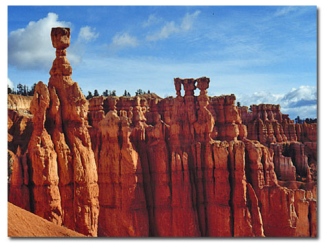
Some of the interesting geological formations in Bryce Canyon National Park include:

Thor's Hammer: Visible from Sunset Point.
Wall Street: Visible from Sunrise Point.
Sinking Ship: Visible from Fairyland Point.
Silent City: Visible from Inspiration Point.
White Cliffs: Navajo Sandstone formation visible from Paria View.
Natural Bridge: Really an arch, visible from Natural Bridge turnout.
The Hunter: Hoodoo, with small trees on top visible from Aqua Canyon.
The Poodle: Hoodoo visible from Rainbow Point.
Overview | Climate/Map| What to See | Lodging/Camping | Nearby
Related DesertUSA Pages
- How to Turn Your Smartphone into a Survival Tool
- 26 Tips for Surviving in the Desert
- Death by GPS
- 7 Smartphone Apps to Improve Your Camping Experience
- Maps Parks and More
- Desert Survival Skills
- How to Keep Ice Cold in the Desert
- Desert Rocks, Minerals & Geology Index
- Preparing an Emergency Survival Kit
Share this page on Facebook:
The Desert Environment
The North American Deserts
Desert Geological Terms


