Red Apple Railroad
Exploring the Line
Text & photos by David A. Wright
In downtown Bishop, begin by driving to the intersection of US 395 (Main Street) and Line Street, which is the southernmost signal light in town. The white building on the southeast corner of the intersection, now the Monument Bank, once housed the offices of the joint venture incorporating the "Red Apple" and the Aqueduct Lands and Orchards Company.
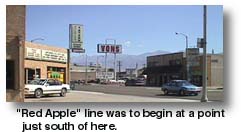 Plans were for the "Red Apple" line to begin at a point just south of here, probably at a point now occupied by the Vons grocery store at Main and Short Street, one block south of the Monument Bank. According to the "Gus Cashbaugh" map and newspaper articles, the grade was to run east along what is now Short Street. No visible remains of the grade can be found along Short, which is a quiet residential neighborhood today.
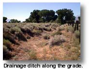
The second access to the grade is located on East Line Street, which is back at the signal light on Main (US 395). Drive east 0.8 miles on East Line and drive and stop. Look closely in the brush and trees both north and south of the road and you will see the grass and brush-covered hump of the grade as it curves and crosses East Line. The grade is further identified by the deep drainage ditches on each side of the grade, each dug rather deep into the ground.
From here the line crosses a small slough on the South Fork of Bishop Creek; no more roads accesses the line for about a half mile further north. To access our third area of the grade, continue east to the entrance of the Bishop Airport, 1.5 miles from the US 395 / Line Street intersection.
Drive north on Airport Road for a 1/4 mile, until a small building with satellite dishes is reached on the west side of the road. This is the starting point for a good dirt road that takes off to the west (left). Turn onto this road and travel slightly less than 1/2 mile until the road makes a sharp turn north (right). This dirt road is smooth and well bladed, suitable for all vehicles. This is a good vantagepoint for a look at the completed grade.
South of the swing of the dirt road, the brush-covered hump of the "Red Apple" grade can be seen as it exits a small slough on the South Fork of Bishop Creek. There are tire tracks along part of the grade, and the remainder is covered in brush. If you walk over to the west side of the grade toward the airport boundary fence line, the grade will become more prominent as viewed from the drainage ditch that was constructed with the grade. This ditch parallels the grade and is about four to 6 feet deep.
 From this point north for the next few miles the modern dirt road runs directly upon the grade of the "Red Apple." At a point where Wye Road intersects with the airport road -- there will be a gate on the west (left) side that may or not be locked, possibly blocking access to or from Wye Road, a structure will be a ways off to your right -- the grade will emerge from under the present road and will make an obvious tangent northeast.
At this point, further progress for a distance further north is futile as far as the "Red Apple" is concerned. In 0.4 miles the road will access the Hyatt sand and gravel pits operation, which has long ago obliterated the grade.
If the gate is locked at the access of Wye Road, you can retrace your route back to Bishop, or better, continue north to the end of the fence line and the entrance to the Hyatt operation (0.3 miles). From here, turn west (left) and then immediately south (left) on a parallel road along the west side of the fence and back to Wye. Follow Wye Road west one mile to its junction with US Highway 6. It is well bladed for the first half, then paved for the remainder.
Bishop contains all services for the traveler, containing plenty of motels, restaurants, all the fast food chains, and markets.
Turn north on US 6 and drive 2.7 miles north and east. Turn south at the dirt road on the right side of the highway.. This road should be okay for most vehicles, but there are some sandy areas. Two-wheel-drive vehicles should avoid getting off of the main, packed roadway is the shoulders are quite soft. If you feel uncomfortable with exploring this area, skip it and proceed to the next section.
The road immediately turns east (left) parallel to the highway toward old cement silo (0.3 miles). At the silo, the road then turns southeast (right) and crosses the Red Apple grade at a point about 1.1 miles from US6. At this point the grade is a low, brush-covered mound.
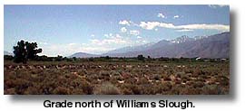
After viewing the grade, turn around and retrace your route about 400 feet. There is a road turning south (left). Turn and after driving about 500 feet, look to your left. You should be able to see the grade, becoming a prominent fill, as it drops gently onto the lower elevation approaching Williams Slough.
Continue south for about 1/4 mile until you come to "T" intersection. Turn east (left) and drive about 100 feet. You will then be on the grade itself, where vehicles have worn a nice roadway upon the grade for some distance south. There is also another roadway paralleling the grade for some distance on the left side.
North of this point, the grade is brush covered. You can see a deep drainage ditch running along the east side. South of here for about 500 feet, the path stays upon the grade. Beyond that point, however, the grade enters the high water table of Williams Slough, and heavy growth of grasses, willows and cottonwoods take over and makes further access impossible, even by foot unless you're especially determined.
Turn around and retrace your route to the point where you first intersected the grade, after turning off US 6 (about a half-mile). Continue east for another 0.1 miles. Turn north (left) on this road and drive another 0.1 mile to a crossing. Turn left and drive about 650 feet, where the road makes a sharp turn to the right and enter an obvious cut. Stop here.
For those who skipped the last section, you can still view the northernmost end of the line. Instead of turning onto the dirt road 2.7 miles north of Wye Road, continue 0.7 miles (or 3.4 miles from the junction of Wye Road and US6) to a point just before the west side of the Owens River bridge.
Follow the prominent dirt road turning right (south) 0.1 miles to an intersection with another dirt road crossing it. Bear right. This road you are driving on is actually the grade of the "Red Apple." Continue for slightly more than 0.4 miles and stop at the uphill end of the obvious railroad grade cut.
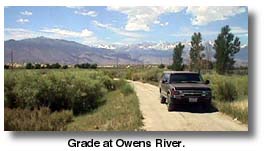
This cut, 11 to 15 feet deep, eased the grade down to the elevation of the Owens River. South of this cut, the grade emerges from under the road you are driving on and becomes a sagebrush-covered hump southward. The spot where you at first accessed the grade after leaving US6 (if you explored the area north of Williams Slough) is southwest about a 0.1 miles, though that road is not visible because of the sagebrush overgrowth.
Turn around or continue north down the cut back toward US 6. From this point on, countless fishermen have driven this road, not realizing they were driving on the dreams of 1911. Exiting the cut, the road bends for a few feet because of later quarrying, then comes out upon an obvious fill, the high point about 17 feet above the surrounding lowland. Continue north on this road as it makes a bend east and dead ends at the Owens River. A bridge across the river was never constructed.
Across the river, you will get a delicious triple scoop of history: the Red Apple, the ghost town of Owensville and the Laws Railroad Museum. From the Owens River, backtrack your route about 400 feet and turn north (right) to access US 6, or you can turn left off the grade at the road end and make your way back to US 6.
Once there, turn east (right) and drive across the river to Silver Canyon Road, 1/4 mile. Turn right here, and drive to the sign advertising the Laws Railroad Museum. There will be a dirt road paralleling Silver Canyon Road on your right. Pull onto this road and access an obvious gate in the fence.
Going through the gate brings you into the site of Owensville, one of the first towns in the Owens Valley. It takes a sharp eye to find anything of the 1860s era town, but people did once live here.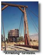
Finding anything of Owensville is very difficult. Going through the gate will land one instantly in a dense sea of chest-high sagebrush, rabbitbrush and grass. About 200 feet southeast of the gate, one can find stones scattered under the sage, encircling a sunken area filled with dense grass and water plants. This is the remains of the stone corral, central in Owensville's history, as it more than once provided a protection for settlers at war with local Indians. Otherwise, other than a couple of depressions and some shards of heavy brown glass, Owensville has been erased from the floor of Owens Valley.
As for the grade of the Owens River Valley Electric Railroad through Owensville, the line crosses the ghost town 450 feet south of the access gate. Walking to the grade you will find the line covered in dense sage, but unmistakable due to the deep drainage ditches and decayed right-of-way fence posts. The line continues east about 900 feet, where it abruptly ends at a leveled area east of the Laws complex. No physical interchange with the Southern Pacific narrow gauge was ever built.
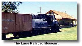
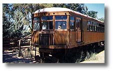 No trip to this area is ever complete without a visit to the Laws Railroad Museum. The Laws railroad complex was donated to Inyo County by Southern Pacific when the narrow gauge line was abandoned in 1960. The county as kept the railroad yards intact, along with one complete train, tanks, side tracks, turntable, shop buildings and other items of interest.There is also a motor car from the Death Valley Railroad on display. In the years since donation, the museum has added several historic buildings from other parts of the valley and has filled them with displays. There are two research libraries on the premises


Share this page on Facebook:
The Desert Environment
The North American Deserts
Desert Geological Terms


