Petroglyphs of the Cosos
China Lake Naval Weapons Center
By A.R. Royo

For years I've been hearing vague rumors about the mysterious petroglyphs of the Cosos -- a series of remote desert canyons brimming with ancient Native American rock art -- hidden from the public on a U.S. military base. Last year, my friend Dr. Anderson, an historian who was preparing a monograph on the subject, finally divulged their location to me.
The material he sent to me indicated that the largest concentration of petroglyphs in the western hemisphere was displayed in the canyons of the Coso Mountains, which are located in a remote region between the Sierra Nevada Mountains and Death Valley, where the Mojave and Great Basin deserts meet.

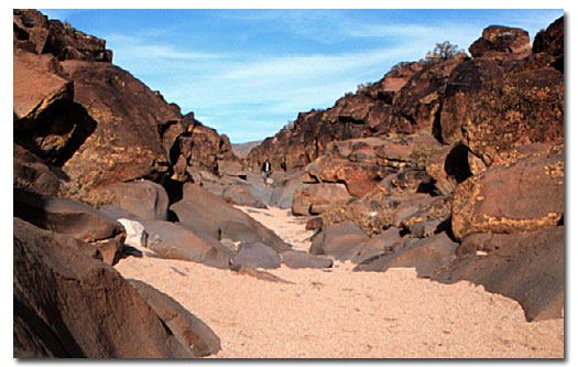
Click on the picture for a video of Little Petroglyph Canyon
The Cosos lie within the confines of China Lake Naval Weapons Center (NWC), the U.S. Navy's largest research and development facility. It encompasses about 1,200 square miles of dry lake beds, desert mountains and volcanic lava flows in southeastern California.

The northern half of this base is the primary target area for missile weapons testing. It is littered with ordnance debris from more than half a century of such tests. It is also permeated with more than 100,000 drawings, pecked into the basalt cliffs and canyon walls during the past 10,000 years. Many of these drawings depict ancient man hunting bighorn sheep with weapons appropriate to his time -- the atlatl (spear thrower) and the bow and arrow.
Desert Hiking Water Calculator
Since establishment of the NAWS base in 1943, public access to the region has been cut off. The canyons (and therefore the petroglyphs) have remained well protected since then. In 1964, two of the canyons were designated a national historic landmark, and the Navy eased restrictions to allow for limited visitation to the sites.
With the cooperation of Naval Command at China Lake, and funding from private foundations and individuals, Campbell Grant, James W. Baird and J. Kenneth Pringle began an archaeological survey of these sites in 1966. Since then, in an arrangement with the Maturango Museum in Ridgecrest, California, the Navy has allowed limited tours into one of these canyons, where many of the petroglyphs are concentrated.
Making Arrangements
 I called the Maturango Museum to see if there were any tours available before year's end. Fortunately, I was able to make two reservations for the only remaining tour of the year. After providing the appropriate information and debiting my credit card $40, I was sent a confirmation, brief instructions for the tour and information on local lodging.
Since the tour started at 8:00 am on a Sunday morning, I decided to stay at a Ridgecrest motel the Saturday night prior to the tour. With a population of 30,000, and supported by the nearby military base, Ridgecrest is the only city within 50 miles that offers all of the amenities of modern civilization . . . and not many of the drawbacks. I pulled into the Heritage House parking lot about 5:30 pm Saturday, just as Cactus Jim was arriving. While I had been exploring the Antelope Valley and the western Mojave, he had been at Randsburg and Trona Pinnacles for the day.
We turned in early Saturday night and woke at daybreak to a glorious view of the pristine southern Sierras to the west and the brilliant Panamints to the east. The temperature had dropped below freezing overnight, and our Jeeps were covered with frost.
We arrived at the Maturango Museum at 7:45 and by 8:00 am, our group had swelled to more than 40 people -- an interesting mix of young and old, couples and singles, archeology, natural history, Native American buffs or just plain tourists. The Navy allows as many as 50 adults and 20 cars on each of the tours, which occur twice a weekend for 8 months of the year.
Our four guides -- two men and two women, all retired -- introduced themselves and showed us a 15-minute video on the petroglyphs site. They answered questions and filled us in on the procedures and policies required by the military. Don Moore, who has made more than 40 trips into the Cosos did most of the speaking. He was obviously excited about the tour, and his excitement was infectious.
They confirmed our names and requested social security and license plate numbers. One of our group was an Irishman with a British passport. The guides weren't sure if he'd be allowed on the base, but after a call to the city police and an apparent determination that Keith was not an Irish terrorist, he was allowed to join us.
By 9 am, we filed out of the museum, piled into the vehicles and lined up in caravan, where, waiting together in Jim's Jeep, we were instructed to maintain our position as next-to-last in line throughout the journey and provided handouts about the tour. We caravaned from the museum north to the Navy base's entrance, one guide in front and one taking up the rear.
Caravan to Cosos
As our caravan wound its way through the paved roads on the base, I read one of the handouts titled "Road Log to Little Petroglyph Canyon" -- describing points of interest at various mileage marks between the main gate and the end of our journey, 40 miles to the north. The log lists various geological features in these volcanic mountains, as well as abandoned silver, gold and copper mines.
As we climbed to the Etcheron Overlook, we saw the 8,839-foot Maturango Peak to the east, the highest point on the Naval base and the namesake for the Maturango Museum. Further east, Telescope Peak (11,049 feet) surmounts the Panamint Range within Death Valley National Park.
We also begin to notice Joshua trees occurring in great abundance. While geologists would maintain that we are in the Great Basin Desert, because we are north of the Garlock Fault, biologists would assert that we are in the Mojave Desert, the presence of Joshua trees being the most telltale sign.

In fact, between there and the petroglyphs, we passed through one of the world's largest Joshua tree forests. As we climbed to 5,000 feet, the top of Wild Horse Mesa, the handout informed us that we were likely to see wild horses or burros, the descendants of animals that strayed from ranches, mines, or crews working on the Los Angeles Aqueduct. From here, we could now see magnificent Mt. Whitney to the west, the highest point in the contiguous U.S. at 14,495 feet.
Exploring the Canyons
It was almost 10 AM when we arrived at the parking lot of Little Petroglyph Canyon where porta-potties and picnic tables were conveniently established and swiftly utilized. We assembled at the site of the national historic landmark plaque while Don and the other guides give us our schedule, the lay of the land and a brief overview of the area's archeology.
There are numerous rock art sites scattered throughout the Coso Range, with perhaps as many as 100,000 drawings. The greatest concentration occurs in two Canyons -- Black Canyon (usually referred to as Big Petroglyph Canyon) and Renegade Canyon (usually referred to as Little Petroglyph Canyon). The Maturango Museum tours are limited to Little Petroglyph Canyon, but professionals are able to access other areas by special arrangement with NAWS.
After examining some Native American metates (smooth rock grinding depressions) and bedrock morteros (grinding hole depressions), we divided into four groups and headed down into the canyon. As we emerged into the sandy bottom, we were immediately besieged by a profusion of strange drawings pecked into the dark basalt rocks of the canyon walls. These petroglyphs fill both sides of the canyon, all the way to the rim, and run in both directions as far as the eye can see.
The strange drawings of men, snakes, bighorn sheep, bows and arrows, atlatls, and many abstract designs that defy understanding, are etched into the patina of desert varnish and are faint or dim, depending on their age. When you suddenly think you've discovered a blank area of the canyon wall, you look again and realize you overlooked a whole panel . . . and in fact, you are leaning against another you had at first ignored. They are all over the place!

Jim and I joined separate groups and set off in opposite directions. I went south with those who were interested in a longer hike, and spent the next two hours scrambling up and down canyon walls to view and photograph the thousands of glyphs. Jim joined the group which would take a shorter tour of the sites. About noon half a dozen of us sat and lunched together in the sun as the canyon grew deeper.
Little Petroglyph Canyon is a sandy wash for much of its 3-mile length. The last mile near the bottom turns into a narrow gorge, 6 to 8 feet wide, with steep walls as high as 60 feet. Here, basalt lines the canyon bottom, scoured smooth by eons of water and rocks cascading through the canyon.

Standing pools of water occur in numerous spots, some still iced over, one of which contained two drowned tarantulas. While there are fewer petroglyphs in the lower canyon, they are still numerous by usual standards, and your eye is continually discovering drawings it had missed at first glance.
Upon arrival that morning, Keith the Brit had immediately headed south down the canyon carrying his drawing valise. When we came upon him just before the canyon empties onto China Lake Basin three hours later, Keith was precariously perched high up on the canyon wall. He was sketching an intriguing panel of petroglyphs, which included what looked (to me) like an eagle carrying off a bighorn sheep.
We gathered up our Irish artist, then headed back up the canyon, as our guides continued to explain various interpretations of the drawings and answer other questions. Part way back, we joined up with another of the groups and chatted amiably together until we met the rest of the tour group at the canyon's entrance.
It was just 3:00 pm, and after being provided with a cup of hot cider by one of the guides, we began our caravan out of the Cosos. Sure enough, within a couple miles, Jim and I spotted a wild horse galloping through a Joshua tree forest atop of Wild Horse Mesa of the Cosos.
Related Books & Gifts - Trading Post
Petroglyph Canyon Tours
Ancient Artists of the Great Basin Desert
Paiutes of the Great Basin Desert
Maturango Museum
Ridgecrest, California
Outdoor Recreation: Desert Photography
Related DesertUSA Pages
- How to Turn Your Smartphone into a Survival Tool
- 26 Tips for Surviving in the Desert
- Your GPS Navigation Systems
May Get You Killed
- 7 Smartphone Apps to Improve Your Camping Experience
- Desert Survival Skills
- Successful Search & Rescue Missions with Happy Endings
- How to Keep Ice Cold in the Desert
- Desert
Survival Tips for Horse and Rider
- Preparing
an Emergency Survival Kit
Share this page on Facebook:
The Desert Environment
The North American Deserts
Desert Geological Terms


