Black Agate Hills
Colorado Desert in California

The Black Agate Hills are a short range of low rounded hills less than a mile east of the middle part of the Black Hills Range in the Colorado Desert of southeastern California. Viewed from a distance – or even fairly close up – it is rather unimpressive. Upon exploration, though, it can be determined that the otherwise forgettable hills produce some outstandingly beautiful thundereggs in the form of both hollow geodes and solid nodules.
The Black Agate Hills Geode Bed, which produces the thundereggs, is often considered to be a part of the Hidden Saddle Beds that very nearly surround it. Because of its unique character, though, it should be viewed as separate. The washes draining the area are not the same, and the geodes are different. Most Black Agate Hills geodes are true geodes rather than nodules; that is, they are hollow rather than solid. Moreover, as a group they tend to be less colorful than those from the Hidden Saddle Beds.

Lack of color, however, does not mean they are not attractive. They often contain thick bands of black fortification agate lining their interiors. Such agates may be either smooth or covered with quartz druse. Some geodes contain layers of clear and white chalcedony. A few may have black or white calcite crystals or, rarely, both at the same time. The predominant colors are black and white, although pink is not unknown. While these geodes may not be as colorful as some, they certainly are striking.

Something else that sets Black Agate Hills geodes apart is their size. They often reach diameters of six inches and more. In fact, as far as I have been able to ascertain, they are among the largest to be found in the Wiley’s Well Rockhound District. One I saw measured more than two feet in diameter! While the southern portions of the area have been worked extensively, the industrious rockhound should be able to go home with several nice geodes measuring four inches and more across, a majority of which can be expected to contain black agate.
As broken pieces of geodes attest, the northernmost hill in the range has been explored by rockhounds. With the exception of a few small holes where someone unearthed a partially buried thunderegg, though, there has been almost no digging. Who knows what may lie just under the surface! Judging by the broken pieces, the geodes should contain a much higher percentage of clear agate than those in the south. Additionally, there should be far more geodes than nodules.
Digging can be a lot of hard work, however, and the rewards cannot be certain. A visit to the Black Agate Hills Geode Bed can still reward rockhounds who prefer not to dig. Agate of various colors can be found on the ground, with many pieces large enough to make nice cabs. Jasper and rhyolite are found as well.
Getting to the Black Agate Hills Geode Bed is easy, even though the last mile or so of road is rather primitive. Four-wheel drive and high clearance can be helpful, but are not required for experienced drivers.

The best way to reach the Black Agate Hills region is to take Interstate Highway 10 to the Wiley’s Well exit located some 15 miles west of Blythe, California. After exiting, turn south on Wiley’s Well Road. About 2.9 miles south of the divided highway, at 33°34.183' N and 114°53.882' W, the paved road turns sharply right toward two large state prisons, Chuckawalla Valley and Ironwood, but you will want to continue southward on the graded dirt road. Some 13.3 miles south of the interstate highway you will reach the Riverside-Imperial County line at 33°25.800' N and 114°54.180' W.
Wiley’s Well Road becomes Milpitas Wash Road in Imperial County, though there may not be a sign to indicate the name change. On the other hand, you should see a sign indicating that the Hauser Beds are to the west. It was erected in early 2000 by the California Federation of Mineralogical Societies.
Immediately south of the county line, at 33°25.794' N by 114°54.182' W, turn right onto the track that angles southwest across the desert pavement. This will lead you 0.6 mile to what is generally known as the Black Hills Road at 33°25.429' N and 114°54.620' W. Bear right, and continue on the most traveled road past a metal signpost marked “Ashley Flats” and “Gerdes Trail” at 33°24.758' N and 114°56.853' W. For the next few miles you will be traveling over a section of the old Palo Verde-Niland Road, but it is simply part of today’s Black Hills Road.
Continue driving in a generally westerly direction to another metal signpost at a fork in the road. Your GPS coordinates should be close to 33°24.825' N and 114°58.145' W. Located about 4.5 miles from Milpitas Wash Road at the Riverside-Imperial county line, this junction marks the approximate center of what is known as Middle Camp.
Take the north, or right, fork in the road and continue driving westward on the Black Hills Road. Only 0.4 mile ahead, at 33°24.827' N and 114°58.548' W, the old Palo Verde-Niland road departs to the right. It appears that the roads at this point, including the junction, are on private property. Please respect the owner’s rights by complying with the “no trespassing” signs.
About 8.3 miles from the county line you will drive into a packed-gravel wash. After traveling maybe 20 yards, at approximately 33°24.117' N and 115°01.523' W, you will notice roads leaving the wash on both sides. The steep one, departing to the south, is a jeep trail to the Straw Beds. To remain on the Black Hills Road to the Black Agate Hills, turn right.
Only 0.2 mile beyond the wash, approximately 8.5 miles from the county line, at 33°23.992' N by 115°01.817' W, you will reach the eastern edge of the Hidden Saddle Beds collecting area. Here and there you should be able to see evidence of digging.
Continue in a generally westward direction another 0.1 mile to 33°23.919' N by 115°01.901' W, where a less used road turns northward from the Black Hills Road you have been following. It goes toward the Black Agate Hills Geode Bed.
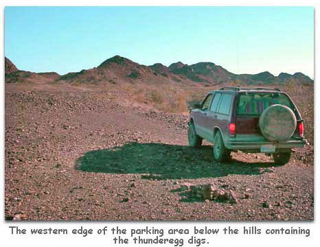
Turn there and drive northward not quite 0.2 mile to 33°24.012' N and 115°01.943' W where you will find a parking area at a trail leading to thunderegg digs on both sides of a series of low, but fairly steep-sided, hills. You should be about 8.8 miles from the county line and 22.1 miles from where you exited the interstate highway.
Those wishing to acquire some Black Agate Hills thundereggs should hike the trail just west of the wash at the western edge of the parking area and climb in a northwesterly direction to the top of the hill, where the pathway forks. The left fork goes down to a little valley and a collecting site at 33°24.095' N by 115°01.974' W. The way the crow flies, it is about 0.1 mile from the parking area. The right fork goes northward to a dig at 33°24.127' N by 115°01.976' W. It is perhaps 200 yards farther from the parking area than the west dig. Both areas yield very nice geodes and nodules, but generally only after a certain amount of sometimes laborious digging. Look also for seams of black agate.
The best time to visit the Black Agate Hills Geode Bed is from about mid-October to early April. Summer temperatures in the area commonly reach 115 to 120 degrees Fahrenheit in the shade, and there is no shade at the dig.
Those who would like to camp near the geode bed may do so provided they stay on public land and remain within 300 feet of an established road. Many rockhounds like the shaded camping spots at Middle Camp. Rangers from the Bureau of Land Management may enforce a 14-day limit. Camping is also allowed at the developed Wiley’s Well and Coon Hollow campgrounds. You will have passed the entrances to those campgrounds on Wiley’s Well Road. They are part of the Mule Mountains Long Term Visitor Area where fees are charged from September 15 to April 15.
When you go be sure to take plenty of drinking water and food for yourself and those with you, plus gas, oil, water, and a tool kit – including a tow strap – for your car. While service is spotty at best, a cell phone sometimes can be used to call for help should it be needed. Before leaving home, let someone you trust know your itinerary. In short, do all those things the survival manuals warn you to do when visiting some remote part of a desert—including paying special heed to the warnings about dehydration. No water is available at the site of the digs, nor, for that matter, anywhere else in the Black Agate Hills. Without a doubt, the best assurance of a successful trip is to use the buddy system of having at least two vehicles along. The closest services and supplies are found in Blythe.
by Delmer G. Ross,
Professor of History, La Sierra University
Photos by Karen A. Ross
If you don't have time to look. Click Here

![]()
Agate - Rock of the month
North Black Hill Geode Beds
Collecting Thundereggs at the Straw Beds
Rockhounding, treasure hunting and gold prospecting links
Related DesertUSA Pages
- How to Turn Your Smartphone into a Survival Tool
- 26 Tips for Surviving in the Desert
- Death by GPS
- 7 Smartphone Apps to Improve Your Camping Experience
- Maps Parks and More
- Desert Survival Skills
- How to Keep Ice Cold in the Desert
- Desert Rocks, Minerals & Geology Index
- Preparing an Emergency Survival Kit
Share this page on Facebook:
The Desert Environment
The North American Deserts
Desert Geological Terms


