McCain Valley
Resource Conservation Area

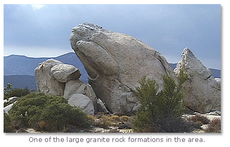
View from Sacatone Overlook
Located 70 miles east of San Diego, the McCain Valley Resource Conservation Area encompasses 38,692 acres of the In-Ko-Pah Mountains, one of Southern California's coastal mountain ranges. Although the In-Ko-Pah Mountains contain few dramatic peaks, this broad rolling upland area is strewn with numerous large granite rock formations which tower above the chaparral-covered landscape.
Oriented generally northwest to southeast, the mountain range rises gradually above the broad green expanse of McCain Valley in the west and drops off dramatically into the dry depths of Carrizo Canyon in the east.
This area is managed to provide for a variety of uses, including recreation, wildlife conservation, cattle grazing, and protection of archaeological resources.
Points of Interest
Sacatone Overlook
From the Sacatone Overlook area you can view Carrizo Gorge, which is the narrow southern section of Carrizo Canyon. If you look across the gorge, you can see a portion of the San Diego to Arizona Railroad also referred to as "The Impossible Railroad".

If you have a pair of binoculars, you may see some old railroad cars that have been abandoned on the hillside below the track. Near the overlook point is an old abandoned mine called "The School Mine." Do not enter the mine. It can be extremely dangerous. Poisonous gases within mines and open mine shafts can be life-threatening hazards. The Sacatone Overlook is located on Sacatone Spring Road, which leaves McCain Valley Road 2.8 miles north of Old Highway 80.

View from the inside of the old School mine.
Carrizo Overlook
This scenic viewpoint is located a short distance east of the main road. To the southwest is McCain Valley. The rolling crest of the In-Ko-Pah Mountains extends away to the west and north. To the east is Carrizo Canyon.

Looking northeast across the mouth of the canyon, the Carrizo Corridor is visible. This gap in the mountains provided an access route for early Spanish, Mexican, and American travelers, including those on the Butterfield Overland Stage. On a clear day, the Salton Sea, some 60 miles away, is visible through the corridor.
Native American Life
Though Native Americans have lived in the region for approximately 10,000 years, we are most familiar today with the Kumeyaay or Southern Diegueno Indians. These people hunted game and gathered plant resources in the In-Ko-Pahs until the early 1900s. Each spring they moved from winter settlements at lower elevations into the coastal mountains, following wildlife and making use of acorns, seeds, and other plant materials as they became available. In the fall they returned to hunting and gathering areas in the inland valleys to the west or to the desert in the east.
Signs of Native American occupation are fairly common in the McCain Valley. Bedrock morteros, or grinding holes, are some of the most interesting and readily identified. Two places to find them are in the rocks south of Site 11 in West Cottonwood Campground and near Site 25 in East Cottonwood Campground.
If you find pieces of pottery or other remains of Indian life in the area, PLEASE DO NOT COLLECT THEM! Instead, leave them where they are and inform a Park Ranger or the El Centro BLM Office of their location so that archaeologists can study these cultural artifacts in place. Removal of cultural resources is prohibited by federal law and subject to fines or imprisonment.
History of McCain Valley
In 1852, George McCain homesteaded and began grazing livestock in the valley which now bears his name. His family continues to ranch here today. During the 1860s and '70s, additional settlers arrived in the McCain Valley region due, in part, to the discovery of gold near Cuyamaca and Julian. In spite of a temporary flurry of mining activity, ranching continued to be the dominant force in the economy of the region for nearly 100 years.
How The Land Was Formed
Tremendous earth upheavals and persistent erosional forces over the eons have played important roles in sculpturing this region. A series of earth quake faults related to the San Andreas Fault extends along the eastern edge of the coastal mountains. Over a period of 150 million years, the land mass west of the fault system has been pushed up to form the mountains, while the land mass east of the fault system has dropped down to form the Salton Trough, of which the Imperial Valley is a part. Movement along the faults in the zone between the two land masses has produced the Jacumba Mountains, a series of north-south ridges and canyons at progressively lower elevations between the In-Ko-Pah Range and the lower desert country of Imperial County. Carrizo canyon is the most spectacular of the north-south canyons and forms the dividing line between the In-Ko-Pah and Jacumba Ranges.

Plants and Wildlife
The eastern edge of the In-Ko-Pahs marks the transition zone between the high chaparral shrublands of the coastal mountains and the low Colorado Desert country which occupies the Salton Trough to the east. This transition from chaparral to desert has produced a wide range of environments within the area. These habitats support many types of wildlife and plant species, and in the past years provided Native Americans with sources of food and shelter.

Mixed Chaparral: Chamise, redshank, scrub oak and other shrubs, from the predominant plant community along McCain Valley Road and the rolling upland country make up the broad crest of the In-Ko-Pah Range. Chaparral is the product of a Mediterranean-type climate characterized by long, hot, dry summers and moderate winters. The shrubby plants here provide food and shelter for mule deer and other wildlife such as black-tailed jackrabbits.
Fire is an integral part of the life cycle of chaparral. The low moisture level in summer and dense concentration of shrubs produce conditions ideal for burning. For this reason, the plants are well adapted to survive fire, and many depend on it to reproduce.
Semi-Desert Chaparral and desert scrub: These plant communities occupy the eastern slope of the In-Ko-Pahs in Carrizo Canyon. Semi-desert chaparral (with such plants as California juniper, mountain mahogany, and Great Basin Sagebrush) occupies the upper slopes, while desert scrub (represented by brittlebush, agave, cholla cactus, and catclaw) is found on the very steep slopes of the inner gorge. These plant communities are the realm of the Peninsular bighorn sheep, which depend on the difficult terrain to protect it from predators.
The Peninsular bighorn is designated "Rare" by the State of California and is a fully protected animal. While an estimated 80 to 100 sheep live in the In-Ko-Pah Mountains, research indicated the population is declining. Studies are underway to determine the reasons for this trend and to develop a management program which will reverse it. Concern for the bighorn and the protection of archaeological resources resulted in the designation of much of the area east of the McCain Valley Road as the In-Ko-Pah Mountains Area of Critical Environmental Concern (ACES). Restrictions have been placed on vehicle use in the ACEC, and a portion of the area has been closed to cattle grazing in an effort to improve conditions for the sheep.
Other Plant Communities
Water adds a variety of additional plant communities to the environment of the area. The hollows of the west side of the In-Ko-Pahs are occupied by oak groves, which provide habitat for birds, such as the great horned owl and red-tailed hawk, and for antelope, ground squirrels and other small creatures. The oak groves also provide a pleasant setting for Lark Canyon and Cottonwood Campgrounds. On the east side of the range, streamside woodland communities of cottonwood, bay and sycamore occupy the upper portions of Pepperwood and Bow Willow Canyons. Small oases of native fan palms are found in the lower areas of Bow Willow and Jacumba Jim Canyons. These tiny islands of lush vegetation provide a home for bighorn sheep and other desert species. Because these areas are fragile and easily disturbed, backpackers should camp at least 600 feet away from them.
Source: BLM, and DesertUSA staff
Located 70 miles east of San Diego, the McCain Valley Resource Conservation Area encompasses 38,692 acres of the In-Ko-Pah Mountains, one of Southern California's coastal mountain ranges.
More on Area
San Diego and Arizona Railroad: "The Impossible Railroad"
The Buffalo Soldiers: "Where They Went Peace and Civilization followed."
McCain Valley Recreation Area


Share this page on Facebook:
The Desert Environment
The North American Deserts
Desert Geological Terms


