Colorado River Lake Levels, Water Temperatures
May 2026
The Colorado River is the lifeblood of the desert Southwest—carving canyons, powering cities, and creating some of the region’s most popular recreation lakes. Along its path lie Lake Powell, Lake Mead, Lake Mohave, and Lake Havasu—each formed by monumental dams and offering endless opportunities for outdoor fun.
Whether you’re boating, fishing, swimming, or camping, these lakes draw millions each year with their warm waters, stunning scenery, and year-round sunshine. This page provides real-time lake levels and water temperatures, so you can plan your trip with confidence—whether you’re launching a boat or just looking to cool off.
Explore the best ways to enjoy the Colorado River’s lakes—right here in the heart of the American Southwest.
Boating Supplies - Water Filters - Water Straws to purify drinking water
Click on the links below for more information on each lake.


Lodging Where to Stay - Boating
Water Level and Temperature
Water level up to 31.4% full
Water temp 59+

Lodging Laughlin, NV - Bullhead City, AZ
Water Level and Temperature
Water level 97% Full
Water temp 59+

The Colorado River, a crucial water source for over 40 million people across seven U.S. states and Mexico, is facing significant challenges in sustaining its supply to downstream cities, agricultural regions, and water bodies like the Salton Sea. The original 1922 Colorado River Compact allocated water rights based on overestimated flow measurements, leading to commitments that exceed the river’s actual capacity. This overallocation has been exacerbated by prolonged droughts and climate change, resulting in diminished water levels in major reservoirs such as Lake Mead and Lake Powell.
The long-term outlook for the Colorado River is concerning. Studies indicate that the river’s flow has declined by approximately 20% over the last century, with projections suggesting further reductions of up to 31% by 2050. This decline threatens the water security of major urban centers, agricultural operations, and ecosystems dependent on the river. The Salton Sea, for instance, relies heavily on agricultural runoff from Colorado River water; reduced flows could accelerate its shrinkage, leading to environmental and public health issues. Addressing these challenges requires revisiting existing water allocation agreements, implementing more efficient water use practices, and developing adaptive strategies to cope with the anticipated decrease in water availability.
Boating Supplies - Water Filters - Water Straws to purify drinking water
The Colorado River is shrinking, and the Southwest is running out of time. This video explains why the river is drying up, who’s affected, and what solutions may still be possible before it’s too late.
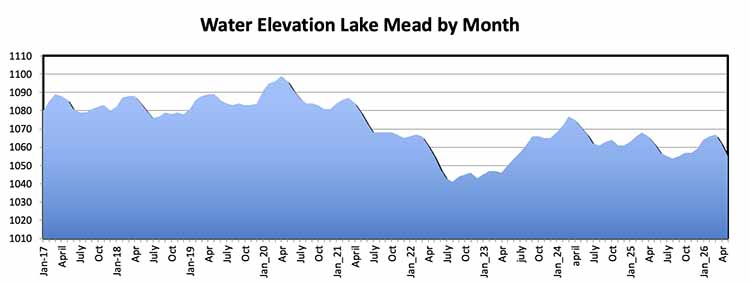
Lake Powell
Lake Powell Status – May 2026
Lake Powell’s elevation is currently around 3,526 feet above sea level, leaving the reservoir roughly 23% full and more than 170 feet below full pool. Water levels have declined significantly through the winter and spring of 2026 due to weak snowpack, below-average runoff, and ongoing drought conditions across the Upper Colorado River Basin.
USBR forecasts show Lake Powell remaining under serious pressure through late 2026 and into 2027. Earlier 24-Month Study projections suggested the lake could potentially fall near or even below the critical 3,490-foot minimum power pool level by late 2026 or early 2027 under dry conditions, threatening hydropower generation at Glen Canyon Dam.
In response, federal officials have announced emergency operational measures, including reduced releases from Lake Powell to Lake Mead and additional upstream releases from Flaming Gorge Reservoir, aimed at keeping Powell above critical elevations. Current plans are expected to help stabilize the lake near or above 3,500 feet into 2027, although much depends on future runoff and weather conditions.
Lake Powell remains a critical part of the Colorado River system, supplying water and hydropower across the Southwest. While the situation is serious, emergency management actions and future weather patterns will play a major role in determining whether conditions stabilize or continue declining over the next two years.
Water Elevation Lake Powell By Month
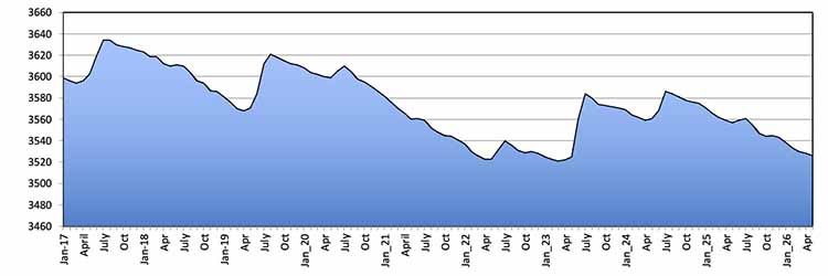
Chart by year from 1998 to 2026

Lake Powell is down 31.81 Feet from one year ago.
Water releases from the Glen Canyon Dam fluctuate based on power needs, which can sometimes leave downstream river users high and dry - literally! Generally, less water is released on Sundays. The Colorado River provides water for 40 million people across the Southwest.

Road Conditions Check for updates
The public is asked to use extreme caution when using the public launch ramps at Lake Powell. Most of the main boat ramps are open. The deepest launch ramp at Lake Powell continues to be Wahweap main ramp. Different boat/trailer combinations require varying depths of water, so remember to assess the water depth for your boat before launching.
Due to significant wind damage and low water conditions, Dangling Rope Marina is closed until further notice. The damaged docks are not safe for visitors or employees.
Hite retail store, pay-at-the-pump fuel service, the visitor comfort station, and designated camping areas will be closed. Public restrooms at the Hite Ranger Station, fresh drinking water spigot and RV dump are open. Plan your fuel use ahead.
New Tiered Boat Pass fees begin Monday, March 4, 2024. The passes will better align a fee structure that will reflect costs associated with the needs of vessels utilizing Lake Powell.
7/15/2024 Stateline Main Launch Ramp Temporarily Closed
The Stateline Main Launch Ramp is temporarily closed to accommodate staging for vessel salvage operations. Stateline Auxiliary Ramp remains open.
The lake level is changing every day: keep alert!
More information on changing lake levels
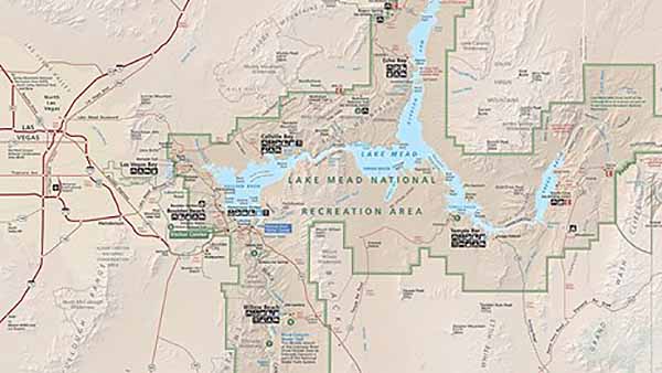
Lake Mead
Lake Mead is down -6.22 feet from one year ago.

Current Status (as of early May 2026
Lake Mead Status – May 2026
Lake Mead’s elevation is currently around 1,055 feet above sea level, leaving the reservoir roughly 30% full. While this is still above the record low reached in 2022 (about 1,040 feet), the lake remains far below full capacity and continues to reflect the long-term effects of drought and reduced Colorado River runoff.
Recent USBR (U.S. Bureau of Reclamation) forecasts suggest Lake Mead will likely continue a gradual overall decline through late 2026 and into 2027, despite normal seasonal fluctuations. Most-probable projections show the lake potentially dropping into the upper 1,030-foot range by mid-2027, with drier scenarios approaching the Tier 3 shortage threshold near 1,025 feet.
Lake Mead is currently operating under Tier 1 shortage conditions, and additional shortage declarations remain possible if water levels continue to fall. This could lead to deeper water delivery cuts for Arizona, Nevada, Mexico, and some agricultural users along the Colorado River system.
Even so, Hoover Dam’s hydropower system is not in immediate danger, as lake levels remain well above minimum power pool and dead pool elevations. Future conditions will depend heavily on snowpack, runoff, conservation efforts, and new Colorado River operating agreements currently being negotiated for the post-2026 era.
Boating Supplies - Water Filters - Water Straws to purify drinking water
Alerts & Conditions
Lake Mead Ramp Status --
Current Conditions at Lake Mead & Lake Mohave
The park is located in both Nevada and Arizona.
Please check with the most recent state orders before traveling.
Lake Mead NRA has transitioned to a cashless fee collection system, accepting only electronic card payments for entrance, lake use, and campground fees. Entrance stations will continue to sell passes only with credit card.
Most restrooms and stores are closed. Please bring everything you need, including water for you and your pets, and pack out everything you bring in.
Remember, Styrofoam and glass are never allowed in the park. Thank you for keeping your park clean and trash free.
Historic Railroad Trail Tunnel 3 Closed Until Further Notice Due to visible deterioration of the support beams within Tunnel 3 of the Historic Railroad Trail, this tunnel is closed, until further notice. Visitors may hike from the trailhead to Tunnel 3 and back. Access into the tunnel is prohibited.
Lake Mojave and the Colorado river
Multi-vessel/vehicle discounts are no longer offered - for latest fees see park website.
Public vehicle access to the shoreline at Boulder Harbor is no longer be available. The area is now the Boulder Harbor Walking Trail.

Laughlin on the Colorado river.
No one may operate a personal watercraft (PWC) that does not meet the 2006 emission standards set by EPA for the manufacturing of two-stroke engines. A person operating a personal watercraft that meets the EPA 2006 emission standards through the use of direct-injection two-stroke or four-stroke engines, or the equivalent thereof, is not subject to this prohibition and will be allowed to operate as described in this section.

Sunset Katherine's Landing South end of Lake Mohave
The NPS and Forever Resorts, LLC dedicated the first floating building project in the world to be registered for LEED® certification at Lake Mead National Recreation Area's Cottonwood Cove Resort and Marina on Lake Mohave.
The bridge over the Hoover Dam is open for traffic.
DesertUSA has videos on Lake Mead and Hoover Dam, Glen Canyon Dam, Lees Ferry, Rainbow Bridge, and Lake Mojave's Davis Dam and Laughlin, NV.
You can now experience the Colorado River via Google Street View.https://www.google.com/maps/about/behind-the-scenes/streetview/treks/colorado-river/
Take a virtual trip on Lake Mohave and the Colorado river in this DesertUSA video.
Lodging Laughlin, NV - Bullhead City, AZ
Send us your river stories and pictures to share with fellow river lovers. What else do you want DesertUSA to cover in our updates? Let us know. E-mail pictures and comments to Jim@desertusa.com

Glen Canyon Dam

Click on the picture above to read the story of the Hoover Dam Bypass Bridge,
named the Mike O'Callaghan-Pat Tillman Memorial Bridge.


Share this page on Facebook:
The Desert Environment
The North American Deserts
Desert Geological Terms


