A Walk On The Rocks - Part 2
Villager Peak Walk - Anza Borrego Desert State Park
Text and photos by Bill Sullivan
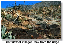
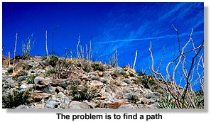
As I moved onward, I noticed that the vegetation was getting thicker, and the peaks and bumps on the ridge to the east across Rattlesnake Canyon were getting closer. By the time I climbed past 2,000 feet, I was seeing century plants and stones so big I had to walk around them, and there were moments when the plants and stones would hide the trail and my problem was to find a path. I had left the familiar environment of the valley below and had entered the environment of the mountains. I also had my first distant view of Villager Peak, with its stubble of tiny trees.
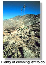
 After 3,000 feet came the delicious feeling of shouldering my way past the massif to the east. I had become a bird or a plane. Points I looked up at from the valley below were now just across the canyon. And I knew that soon I would be able to look down on them. But any thoughts of triumph at this level are not likely to last long. One has but to look to the start of the next steep climb to realize that there is still plenty of climbing left to do.
I also became aware of the differences in terrain from one level of altitude to the next. From down below, the distant ridge looks smooth and monochromatic. The trees around Villager Peak are so small that they hardly seem to signal a difference in the terrain.
But when I started walking the ridge, I began to notice differences in the plants, and differences in the rocks. It was the differences in the rocks that fascinated me the most: the desert varnish before the creek bed, the imbedded rocks at 1,500 feet, flat rocks at 2,000 feet, loose rocks at 3,000 and 4,000 feet, and massive stones in the earth toward the top.
 I thought about the former Native American inhabitants of these mountains, people who walked up here not for recreation but because it was their livelihood and their life. Across the canyon I saw Rattlesnake Spring, a watering hole once shared by Indians and bighorn sheep, but now left to the sheep and perhaps an occasional hiker.
I noted a flat area with sleeping circles about 15 or 20 yards off the trail. It's a good place to camp, providing a fine view of the sunset and also, after the sun goes down, of the red sunset light off the west-facing peaks. I walked off the trail a few feet to look down into the canyon where I could pick out a flat space the size of perhaps a couple of city blocks. I have read that it was once an Indian village, but I don't know when.
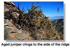
In testimony of the fact that desert bighorn sheep roam this country, but not generally when hikers are present, I found a few well-nibbled krameria plants. When I've seen krameria down below in the valleys where the sheep don't touch them, they grow to become two or three feet high and wide with pretty purple flowers.
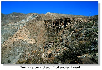
At 4,100 feet I approached the interesting face of a cliff where the soil was darker than the soil around it, giving the impression of being made of old and seemingly fragile mud. When I walked on top of this cliff, I chose not to walk too close to the edge, out of respect for all of that. The face of the mountain was part soil and part marble. I came to an unusually narrow stretch of trail and then stepped onto a fairly flat area leading to the start of yet another climb that would have to be made. I decided to camp. I would go to the summit the next day.
![]()
Villager Peak Walk, Part 1
Villager Peak Walk, Part 3
Villager Peak Trail Notes
Anza Borrego Desert State Park
Fish Creek Walk at Anza Borrego
Coyote Canyon
Related DesertUSA Pages
- How to Turn Your Smartphone into a Survival Tool
- 26 Tips for Surviving in the Desert
- Death by GPS
- 7 Smartphone Apps to Improve Your Camping Experience
- Maps Parks and More
- Desert Survival Skills
- How to Keep Ice Cold in the Desert
- Desert Rocks, Minerals & Geology Index
- Preparing an Emergency Survival Kit
Share this page on Facebook:
The Desert Environment
The North American Deserts
Desert Geological Terms


