Moab, Utah
4x4 Adventure - Mountain Biking - Hikes

Moab, the only town in Utah located on the Colorado River, is the county seat of Grand County (population 8,800) in the heart of the Colorado Plateau. The area is a geological wonderland nestled in a valley with scenic red rock cliffs on both sides and surrounded by rugged and beautiful desert terrain.
The La Sal Mountains, just 18 miles to the east, reach elevations of over 12,000 feet. Meadows, lakes and streams abound in the pine, spruce, fir, and aspen forests. The lush mountain valleys and alpine beauty provide striking contrast to the panoramic view of the deserts and canyons below. This varied topography offers excellent, and practically unlimited, recreational opportunities throughout the year.
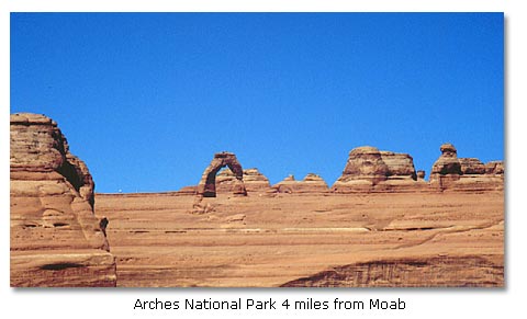
Over 90 percent of Grand County is "public land", administered by the Bureau of Land Management, the USDA Forest Service, the State of Utah, the National Park Service, and State Parks. These lands have many diverse uses, including recreation, woodland products, wildlife management, livestock grazing and mineral resources. Different recreational activities are permitted in these areas, depending on which government agency administers the land. Arches National Park is only 4 miles from Moab, Utah and Canyonlands National Park is 45 miles from Moab.
Population / Elevation
- 5,200
- 4,000 feet above sea level
Weather / Climate
Moab, Utah has a short, mild winter and a long, moderate spring. Spring and fall are the most pleasant times of the year. Because of its moderate climate, Moab has become a popular year-round playground.
| Moab, Utah - Monthly Climate Normals | |||||||||||||
| Year | Jan | Feb | Mar | Apr | May | Jun | Jul | Aug | Sep | Oct | Nov | Dec | |
| High °F | 71.2 | 42.1 | 50.6 | 61.9 | 72.0 | 82.0 | 92.3 | 97.9 | 95.1 | 86.5 | 73.2 | 56.9 | 44.3 |
| Low °F | |||||||||||||
| Avg. °F | |||||||||||||
| Rain | |||||||||||||
History
Moab, Utah was a hangout for Butch Cassidy's Wild Bunch and other outlaw gangs of the 1800s. It was the setting for a number of Zane Grey western novels and used as a location to film numerous western movies.
The discovery of uranium in the area during the 1950s transformed Moab from a small agricultural community to a bustling mining and prospecting center. The uranium boom has long passed, but the area remains rich in oil and potash.
But tourism is now the primary industry of Moab, which has become the launch point for jeep, airplane, white water rafting, canoeing, hiking and cross-country skiing. Moab is regarded as one of the world's best places for mountain biking.
Bordering spectacular Arches National Park and in close proximity to Canyonlands National Park, Moab is the primary tourist, cultural, and adventure city of southeastern Utah.
Things To Do
Moab Slickrock Bike Trail
The Moab/Arches area is famous for its mountain biking. There are many excellent bike trails here, most notably, the Moab Slickrock Bike Trail. The Slickrock trail is a 10.3-mile loop trail which takes about half a day. The trail starts on Sand Flat Road, 2.3 miles from the BLM Grand Resource Area Office. The trails offers great biking challenges and magnificent scenery. The practice loop is 2.3 miles and provide an introduction to biking on slickrock. This trail is rated hardest.
Monitor/Merrimac
This is a 13.2 mile easy loop which starts from the Moab visitor center at the north end of town. Drive north on US 191 for 14.8 miles. Turn left onto a dirt road that crosses the railroad track just before the railroad bridge. Follow the dirt road for 0.6 miles to an intersection which is the starting point and ending point for this loop. The trail follows a jeep trail, wash bottom and slickrock. It features close views of the Monitor and Merrimac buttes, Determination Towers, and the Mill Canyon Dinosaur Trail.
Moab, Utah's Western Adventure Town - DesertUSA article that tells what you can do to really enjoy the Moab area. More...
Hotels/Motels
Moab, Utah has something for every taste and price range. For more information and a complete list of places to stay: Click here for hotel/motel rates, availability, reviews and reservations online.
Camping
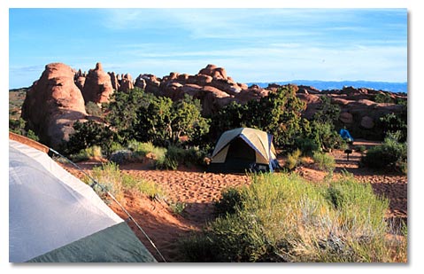
- Arches National Park: The Devils Garden Campground, located 18 miles from the park entrance, has 50 tent and trailer sites (Fee), plus two walk-in group sites limited to tenting for ten or more persons. Facilities include flush toilets and water until frost. Call (435) 259-4351 for information. The Arches campground fills daily mid-March through October, often by early to mid-morning.
- Canyonlands National Park: There are 2 front country campgrounds and numerous backcountry campgrounds.
Nearby Attractions
Cities & Towns
- Monticello, Utah: 55 miles south.
- Castle Valley, Utah: 19 miles east.
- Cisco, Utah: 48 miles northeast.
- Crescent Junction, Utah: 26 miles north.
- Blanding, Utah: 70 miles south.
- Green River, Utah: 49 miles northwest.
Parks & Monuments
- Arches National Park: 4 miles north.
- Canyonlands National Park (Island in the Sky): 45 miles northwest.
- Canyonlands National Park (Needles District): 68 miles southwest.
- Mesa Verde National Park: 150 miles southeast.
- Capitol Reef National Park: 130 miles west.
- Natural Bridges National Monument: 115 miles southwest.
- Monument Valley Tribal Park: 120 miles south.
- Dead Horse Point State Park: 33 miles north.
Recreation & Wilderness Areas
- Glen Canyon NRA (Hite Marina): 162 miles southwest.


Share this page on Facebook:
The Desert Environment
The North American Deserts
Desert Geological Terms


