Ghost Towns of the Mojave
Page 6
From Reveille to Clifford, Bellehelen, Golden Arrow, and Silverbow
Text and photos by David A. Wright
Page 1 | Page 2 | Page 3 | Page 4 | Page 5 | Page 6
Day 6: Wednesday, April 15
Well, it's Wednesday, April 14. It's five after seven. Kind of slept in this morning. Ah! The sun is shining brightly inside my truck. [Sigh] It was cold last night. I don't know what the temperature was, but it was chilly. [Sniffle]
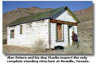
Stretching, yawning and rolling out of the back of the truck, those were the first words of the day I recorded. For a change, Alan had awakened and was out before me, taking photos of the brightly lit ruins of Reveille in the first light of the day. I quickly joined him.
Initial discoveries of silver on the east side of the Reveille Range occurred during 1866 and a camp christened Reveille, the name taken from the widely read and respected Austin newspaper -- the Reese River Reveille, was formed from wood, stone and brick. By the next year, a post office opened its doors for business September 24, 1867, and extensive development work begun.

Freight came to camp from Austin via a 6-day teamster operation over the intermediate mountains and valleys. A 5-stamp mill was built near town that year, and in 1869, a 10-stamp mill was built 12 miles west over the range in Reveille Valley. Shortly after the town's future looked bright, a short slump made for some dull times, and the post office closed December 14, 1868. A hectic, irregular pattern of production and idleness, along with post office openings and closings, would soon begin and prevail throughout Reveille's lifetime.
 The camp went on an upward cycle in 1870, and the post office reopened July 19th, but closed June 4, 1875. A month later, the Gila Silver Mining Company acquired the principal properties at Reveille and nearby canyons, repaired the 10-stamp mill in Reveille Valley, and began four years of steady production. The post office again awarded Reveille its business between August 20, 1875 through Reveille's decline cycle and closed again August 21, 1880. Two years later, Reveille revived enough to reopen the post office; this time it lasted nearly 20 years June 12, 1882 to April 30, 1902.
In 1904, the camp of New Reveille sprang up 6 miles southwest across the range, infusing new interest in the old camp. The post office once again took interest in Reveille, opening for business under the name of Morristown on August 29, 1904. On June 13, 1905, the post office reverted back to the name of Reveille, holding that title until its doors closed for good December 31, 1911. Reveille has been idle since, although small operations kept the Gila Mill operating until 1945. During the Nevada mining boom of the early 1980s, operations in Reveille strip-mined some of the old shafts, and roads were carved through the forests all over the range.
At Reveille I found a collection of stone ruins set amid juniper, piñon and sagebrush. One lone wooden structure stood intact, still wearing a coat of fading white paint. During the early 1980s, this structure was reportedly restored and used as a storage shack. Today, only the wild horses have any use for Reveille, and people like Alan and myself also take delight in finding leftovers from a day gone by. From the looks of the seldom-traveled road, few find reason to do so.
Alan and I had a full plate of ghost towns to visit today, so we disembarked to the next canyon over to look at the ruins surrounding the Gila Mine. Signs of old and new mining: stone walls and concrete cyanide vats, wooden ore bins and strip mining; and a maze of roads zigzagging up the mountain to the very crest were what we found at the Gila Mine site.
While we were viewing the remains of Old Reveille, Alan was consulting his map and noticed that there was a cemetery at Reveille and wanted to view and photograph it. According to his map, it appeared to be near where I had camped for the night. We backtracked to that spot and found a very dim route leading up from where I had parked. Walking up the path, we eventually found remains of wooden fencing that once surrounded the graves. No headstones were seen on the three plots that we found.
The next location on our itinerary was the west side of the Reveille Range and eventually the Reveille Mill on the west side of the Reveille Valley. To access it, we decided upon an overland route instead of backtracking to Nevada 375 and going around the north end of the range near Warm Springs. Taking the first dirt path heading north, we wound our way on a dim trail for nine miles via the former Oasis Ranch, where there were collapsed remains of the house and intact corrals; and the Arrowhead Post Office, where we found nothing.
We topped the range near 7,532-foot Streuben Knob through an open, juniper and piñon filled saddle. We drove a bit south, then up to the top of the snowy Reveille Range at the old Keitzke Mine. Glancing over the crest, we found that we were looking directly down upon the old Gila Mine, where Alan and I were previously, probably a half mile below, with a maze of interconnecting roads in between the two points.
After our brief view from the rim of the Reveille, we then steered our vehicles across the Reveille Valley to the old Reveille Mill. Dropping down the range to the Reveille Valley floor, we drove through an '80s era placering operation, then a group of pronghorn antelope. It was awe inspiring to watch that group gallop full speed, maybe 40 to 45 miles per hour, through sagebrush without stumbling.
At the Reveille Mill, first built in 1869 and used intermittently until 1945, Alan and I found abundant water flowing into a tank, a small grassy area growing around it, a couple of collapsed buildings, and the framework of the mill standing against a picturesque backdrop of the snow-covered Kawich Range.
We then drove northward for nearly 14 miles, driving upon a freshly graded dirt road through the Reveille Valley, passing Nye County road crews as they worked the road for summer travel, then reached Nevada 375 0.8 miles east of US 6 and Warm Springs. At the latter point, 49 miles east of Tonopah, we turned our vehicles westward on US 6. Crossing a juniper-covered summit, we drove west for another 14 miles to the Stone Cabin Valley, then turned south on a dim road to access Clifford ghost town site, two miles south of the highway.

Clifford
The Clifford brothers, Ed and James, discovered silver in the Stone Cabin Valley in December, 1905, and then sold their claim for $250,000. Within two weeks, 40 tents were pitched with the obligatory saloon. Many prominent men of the era, such as Charles Schwab, and "Diamondfield Jack" Davis had holdings in Clifford. The population peaked in 1908 with about 100 houses, tents, saloons, dance hall, stores, and boardinghouses. The post office was known as Helena (not to be confused with Helene, near Delamar), and operated between December 8, 1908 and July 15, 1909. There was a stage line to Tonopah. The camp died during the panic of 1908, but leasers were active at times during the decades since.
Alan and I found one set of stone walls, a wooden dugout, a late 1920s or early 1930s truck cab and chassis, and tumbled remains of other wooden and stone structures.
Our next stop was Bellehelen ghost town site, seven miles southeast in the Kawich Range. Driving upon a dim path that hadn't seen tire tracks in a moon or two, we drove into the piñons of Bellehelen Canyon, occasionally crossing paths with wild horses and antelope.
Bellehelen
Bellehelen was founded as an outgrowth of the Silverbow boom in 1904, in which silver and gold were found in a remote canyon on the west flank of the Kawich Range. The days of the grizzled old prospector and faithful burro had given way to sharply dressed men with an automobiles as their companions of choice, who sped through the sagebrush-covered valleys to any mountain range in sight and started chipping outcroppings, then ran back to Tonopah to record their finds and start a flurry of stock promotion.

The camp was hardly a contender for a few years as other booms such as Goldfield, Rhyolite and others vied for everyone's attention. A post office for Bellehelen was applied for in April 1907 but rescinded. Bellehelen languished as a small camp until that year, when George Wingfield's engineers came to camp to inspect properties; they left unimpressed. During 1909 and 1910, the camp's production did attract around 500 to the site. The post office began business October 15, 1909.
By 1911 Bellehelen went into decline. The post office closed November 15th. The camp was abandoned until 1917 when the Pacific States Mining Company began to work the old prospects in a large operation. In 1922, the company merged with the Tonopah-Kawich Company and a huge cyanide process mill was built. It proved to be a failure, however, and worked only intermittently until 1927, when it shut down for good.
Alan and I didn't find much of Bellehelen, only 3 or 4 stone walls. We had our hopes on finding the site of the large Bellehelen Mill shown in Paher's book, NEVADA GHOST TOWNS & MINING CAMPS. Alan and I split up and took different roads up different canyons, a half hour search by each of us turned up nothing in the thick piñon forests above the camp.
Golden Arrow
 Our next destination was the ghost town of Golden Arrow, located about 12 miles southwest of Bellehelen. We again traveled dim routes no doubt created during staging days when these towns were young and fresh. Instead of Studebaker or Thomas Flyers, our Ford and Chevy 4x4s bounced around in the grass-covered Stone Cabin Valley, bound for towns whose days of glory had long passed. Wild horses running alongside our vehicles made for visions of times long past when their ancestors pulled wooden stagecoaches bound for Golden Arrow and Silverbow. Vistas in the Stone Cabin Valley extended far south to the Goldfield Hills and the Lida Range, more than 65 miles southwest. Soon we came to the rubble that marked Golden Arrow.
Gold ore was found between October 1904 and September 1905 in the Stone Cabin Valley at the western foot of the Kawich Range. In 1906, the Golden Arrow Mining Company laid out a townsite. A railroad was surveyed through here in October 1906 as part of a line planned to connect Tonopah and Ely, but never materialized. By 1907, the camp contained a hotel, store and saloons. But the boom fizzled by the next year. No post office or school set foot in this camp of broken dreams.
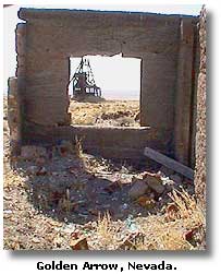
At Golden Arrow, Alan and I found one intact and photogenic headframe with attached enclosed structure, substantial litter from the lumber of collapsed shacks, one intact set of walls, mining junk, cattle, fuzzy rodents, wild horses and curious antelope.
Silverbow
The next stop and the last ghost town on our trip was Silverbow, which lay 15 miles southeast and over the Kawich Range. Silverbow townsite lay straddling the boundary fence of the Tonopah Test Base and the northern boundary of the legendary Area 51. Traveling over a low, piñon and juniper-studded summit at the southern end of the Kawich Range, Alan and I dropped into Silverbow about an hour after leaving Golden Arrow; some backtracking was necessary due to getting temporarily lost in the dense piñon forest nearby. Due to concern for my fuel gauge reading less than a quarter tank, I elected to leave my truck at a point nearby with the distinctive name of Stinking Spring (no, I did not notice anything unusual about its odor).

Silver was discovered in the autumn of 1904. The following year, George Wingfield and George Nixon, prominent Goldfield men, platted a townsite. The silver ore was compared to that of Goldfield, and soon the camp flourished. Silverbow was blessed with ore, water and wood, scarce in many south-central Nevada camps, and soon the camp was the largest in the region.
By autumn of 1905, the camp contained stores, saloons and a meat company. On August 5, 1905, the first issue of the Silver Bow Standard was published and distributed. Its editor was R. Leslie Smaill, formerly editor of the Fallon Standard. As a publicity stunt, Smaill auctioned off the first issue of the newspaper, which was sold for $7. His next stunt was part of the January 6, 1906 issue, in which he printed the first page with a brilliant mixture of yellow ink and gold dust that was assayed with a value of $80,000 per ton.
A post office opened as Silver Bow on September 27, 1905 and a weekly stage ran to Tonopah. Silverbow was somewhat open and wild; a popular pastime was claim jumping, which resulted in at least one death due to gunplay on the street. The first shipment of ore was made early in 1906, but the town suddenly went into decline late the same year. The Standard folded shortly after its grandiose publicity stunt, and Editor Smaill left for the camp of Manhattan north of Tonopah to publish the Manhattan News. A large enough population remained to support the post office until November 30, 1907. There were small revivals in 1913 and 1920, but neither revived the camp.
Today you will find solitude in Silverbow, along with several wooden and corrugated tin structures, stone walls, foundations of the mill, a grave with the inscription "FRED NEWTON - 1870 - 1822 [probably 1922] My Beloved Husband." The boundary fence of the Tonopah Test Base / Area 51 cuts across Silverbow about where the piñons thin out and the vista opens to view the cluster of government buildings at Antelope Dry Lake about 13 miles away. Silverbow continued south toward nearby Nixon Hill, and some ruins could be temptingly seen but not legally explored south of the fence.
After enjoying the late afternoon at Silverbow, it was time to feed empty stomachs and low gas tanks. We had traveled more than 200 miles since filling our tanks at Ash Fork, much of that travel was in four-wheel-drive, or blasting along at 75 miles per hour against a stiff headwind on Nevada 375. Tonopah was our next stop to top off gas tanks and appetites. Our route to Tonopah was to take us to the very gate of the Tonopah Test Base.
Retracing our route back into Stone Cabin Valley, we reached the primary bladed dirt road running down the middle of the valley, then turned south. The White Mountains, about 90 miles westward and largely within California, were silhouetted against the setting sun; an indicator that the trip was nearly over, for White Mountain Peak is visible from our ultimate destination at Big Pine in the Owens Valley. Continuing south, Alan and I came across the boundary fence of the Tonopah Test Base, then followed road turned west for a short distance; the dirt road ending at the main paved access road at the very gate of the base. Armed guards sternly watched us as we drove close enough to make eye contact, then we turned north and blitzed toward US 6, only 18 miles away.
Reaching Tonopah at dusk, Alan and I paid the highest gasoline price for the entire trip, Alan noted that gas had risen six cents since he came through town six days earlier. After filling our very thirsty gas tanks, we drove over to the Banc Club, owned by Jim Marsh of Las Vegas, who we had earlier visited. There we amply filled up our personal gas tanks with good food, inexpensively.
As Alan and I left Tonopah, I noticed that the famed Mizpah Hotel was at the time permanently closed, although lights were on and the "vacancy" sign was lit. Alan and I were notified by Jim Marsh while visiting him at his automobile dealership in Las Vegas earlier that efforts were underway to reopen the historical landmark. Leaving Tonopah city limits, off into the dark night Alan and I raced westbound on US 6. After passing Coaldale and the split with US 95, there was so little traffic that it was seldom necessary to dim our high beams.
Reaching my other home at Big Pine, south of Bishop in the Owens Valley, two hours and one minute after leaving the Banc Club at Tonopah, the trip Alan and I had taken together had officially come to an end. The following morning I was to depart for home in Ridgecrest, and Alan to his home in Oregon.
After it was all said and done, 1,100.5 miles of tarmac, sand, sagebrush and history had rolled under my wheels; we had spent 157 hours and five minutes together away from our wives and homes (Alan had spent an extra five days total on this trip than I); I had consumed nearly 5 hours of video; shot innumerable digital photographs with my Sony digital camera; and Alan and I enjoyed a trip we will always remember.
End of page 6
Page 1 | Page 2 | Page 3 | Page 4 | Page 5 | Page 6
Copyright David A. Wright
Related Pages
Beatty, Nevada
Desert Auto and 4WD Touring
Death Valley National Park
4-Wheeling the Lippincott Mine Road - Death Valley
The Racetrack Playa of Death Valley National Park
4-Wheel Trail Driving Tips
Ballarat Ghost Town - Death Valley


Share this page on Facebook:
The Desert Environment
The North American Deserts
Desert Geological Terms


