Off-Road Trip to Mountain Spring
Text and photos by David Taylor
I clung desperately to the wheel, praying that the front wheels would sooner or later actually grab something. The rear passenger side of my long-suffering Bronco dangled over the hundred foot drop into Devil’s Canyon.

All this to get to a spot, Mountain Spring, which is actually located right next to Interstate 8 and near what was once one of the most difficult mountain passes for westbound travelers headed for San Diego. It was long a haven to Indians, pioneers, muleteers and stage coach passengers. Colonel Kearney bivouacked here during the Mexican American War. There are still ruins at Mountain Spring. Not the ruins of the original stage coach station, but a later lay-over station for freight wagons. When they cut Interstate 8 through this area in the early 1960’s, Mountain Spring actually got more isolated, even as it became an easy sight for west-bound traffic.
Stop at Emergency Water Tank 23, jump the fence, and you can walk right up to the ruins. That, however, is illegal. The only legal way to Mountain Spring is to travel down the original stage coach route, down from Table Mountain.
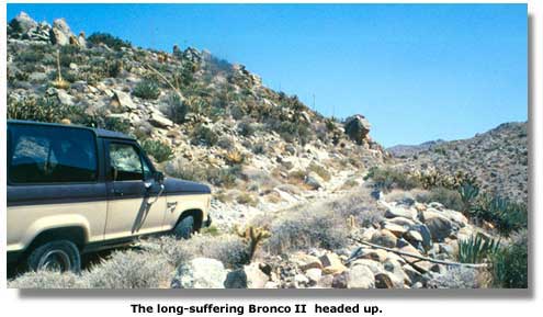
The road and canyon look as if they should be in a black-and-white motion picture, with John Ford directing. There is no relief from the raw and ruddy stone that comes in every magnitude, from pebble to house size. No trees, little brush, nothing to break up the bleakness. From three thousand feet, you look out across Devil’s Canyon, across the Jacumba Mountains, and in the distance, across the Yuha Desert, and finally, the Imperial Valley.
We had parked at the top. I had hiked about a third of the way down the road, and though it was consistently bad, we have driven worse. I peered down the trail, noting that the long-ago builders of this road had piled the excess boulders along the outside edge, so that, even if you tipped over, you would land on the rocks and not slide down into Devil’s Canyon. That seemed reassuring.
I walked back to the truck. A short pow-wow, and off we went.
Despite my reconnoitering, we soon found that the road got progressively worse. The rocks blocking the edge also hid from my sight the sudden drops and baseball-sized scrabble we ultimately forged across. A washout had taken a section of that rock wall. I found myself inching around a Volkswagen-sized boulder sitting in the right side of the road, with Devil’s Canyon a sheer drop off to the left.
I know the Jeepsters dance and sing when they see roads like this, but more than once, I looked back, hoping to find a spot where I could back up to and turn around. It did not exist, so we eased on. I would lay odds that the stage coaches moved quicker than I did. We came through a saddle, and Interstate 8 and the location of the station came into sight. And our road got steeper.
 Finally, we slid between walls of stacked stone and parked. It was disconcerting to stand there and watch traffic crawl by on Interstate 8 below us. The six percent grade, rising from the desert floor at six hundred feet to the pass at two thousand six hundred feet in four miles, guarantees that no one howls past. Still, standing among the ruins that look as if they have not been touched in years even though thousands have seen them, challenges your perspective.
This place felt plainly isolated, lonely.
A large square concrete structure stands above the ruins. We parked and walked through pink-blossomed tamarisk to this suddenly green sight. This is Mountain Spring. Water fills the well, and at the far end, where the mountain talus has slid down and made a beachhead inside the tank, prints of every description, including big horn sheep, mark the path to the clear water. The bottom, maybe three feet down, was covered with round stone, yet there was no real algae in this standing water, no plant life, no mosquito larva twitching around.

I scooped some water out and sniffed it. Suspiciously clean. Poisoned somehow? A crawdaddy shot out from underneath the rocks, as if to dispute that thought. At least that explained the lack of bugs.
Back down below, among walls made of the local red stone, we studied the ruined structures at Mountain Spring. There is a long concrete watering trough, white against the red desert earth, dry and hot in the sun. Two walls divided the trough into three tanks, half-circles cut at the top of each wall so the water would have flowed from tank to tank. I saw no wood on the site, no fire rings, not even trash heaps, only a few very rusted tin cans. The stone hedges, now barely two feet tall, are a labyrinth of corrals and pens covering half an acre or more.

On a small rise to the south, overlooking the original stagecoach road, which now disappears under the raised bed of the freeway, there is another stack of stone, a square with a fireplace at one end. I stepped inside this lone structure and looked around, and thought, even the day this was built, it was a crude, mean place.
I really was not looking forward to going out the way we had come in. I checked out the freeway fence. Someone had cut a hole through the fence a while back, but Caltrans built a berm, blocking all direct exits to the freeway. Another road goes past the well, and it looked as if it might get back to where we had started, but experience has taught us that you had better stay with the devil you know.
The steep grade seemed even nastier rising up. Through the saddle, there is a flat. Overlooking Devil’s Canyon is a row of six-foot tall stones, jutting up like ragged teeth. This would be a lovely place to camp, garden-like in a rugged way. It would have been a pleasant place to check out if I did not know what was up ahead.
Just past the little valley, we came to that Volkswagen boulder. That is where I made my mistake. I hugged the wall, avoiding the sheer drop into Devil’s Canyon. But then I had to ease around the boulder at a much sharper angle than I had done coming down. I was almost through the turn, golf ball- and baseball-sized scrabble slipping underneath my front wheels, when the rear end began migrating to the right, toward the drop-off. It was impossible to tell whether we were gaining ground with all the bouncing. Suddenly the truck shot back onto the road, and I had to turn sharply. I exhaled, relieved.

More noticeable going up, there are small mesas jutting out over Devil’s Canyon that would inspire a landscape artist. The cholla cactus and agave interspersed among boulders had such a natural symmetry that I stopped several times to admire them. Except for an experienced driver with a well-equipped Jeep, this is a hiking project. Yet, despite being right next to Interstate 8, Mountain Spring is well worth experiencing.

Note: This is a day trip from San Diego, California. For those who want to stay for a few days and explore the areas listed below, there is camping in the area. Try Borrego Springs or El Centro for hotels or motels.
To get to Table Mountain Road the author gave the following directions:
Take the In-Ko-Pah County Park Road offramp on I8, and go west on Highway 80. You can see the truck break check station on the freeway, and there's a dirt road that parallels the freeway fence that starts right there. You might as well drop it into four wheel drive at this point. Go north under the underpass and stick to the main road. There's all sorts of wonderful side trips here. If you keep going you end up on Table Mountain, which is a great place, but if you catch the second road to the east, after the private property roads that are well marked "No Trespassing", then you have to feel around until you catch the right road. When you get to the part in the article I talk about, you'll know it.
Related Pages
Anza-Borrego Desert State Park
A Visit To Fossil Canyon and Painted Gorge
BLM California Desert OHV Areas
Fossil Hunting in the Yuha Basin
Yuha Desert OHV Area


Share this page on Facebook:
The Desert Environment
The North American Deserts
Desert Geological Terms


