Peralta Stones Maps - Gold Caches
Anatomy of a Treasure Hunt - Part 3 of 5
By Robert L. Kesselring and Lynda R. Kesselring
Research and Planning: How We Solved the Maps
There were two main considerations in our research.
First, why were the maps created and why were they made of stone?
Second, where did the maps lead us?
Our first task was to perform an aerial survey and then to gather the data from the survey, analyze it and use it to plan for hikes to the Latin Heart site. As we prepared to do the aerial survey, we analyzed many Peralta maps so that we could check as many interpretations as possible from the vantage point of the sky. Those analyses reinforced our interpretation of the Stone Map and the Latin Heart map, because many of the symbols we found were also used on the stone maps. The skin maps of 1844 and 1845 (at the Superstition Mountain Historical Society) show the same area within the Superstitions as the Stone Map represents. They document the location of a cave of gold (Caverna Aurum) trails, campsites and mines. They apparently precede the Stone Map, as it is dated 1847.
Why were the Peralta Stone Maps created and why were they made of stone?
The Stone Cross portion of the map clearly states the map was made to provide for the recovery of the Treasure of the Church of Santa Fe. The Latin Heart Roman Numeral information implies whatever is buried, there are approximately 31,233 of them. Our contact's information from the mine of the Burbridge map spoke of bars of bullion. The bars he handled were approximately four inches wide, eight inches long and three quarters of an inch thick. He also reported church artifacts. His discovery became the foundation for our own expectations.
To understand why the Peralta Stone Map was made, we needed to review its historical context. Our interpretation of that context is based on circumstantial evidence. We felt that events in New Mexico at the time of the Map's creation could be very relevant to understanding it. During the beginning of the U.S. war with Mexico in 1846 Kearny led an army to California on a route that took him through Santa Fe. As he advanced upon Santa Fe the U.S. Army was held at bay in a canyon outside of the city by the Mexican army garrison and others long enough for local officials to take precautionary actions and withdraw to Mexico. After their withdrawal Kearny and his army advanced into the city of Santa Fe. Nobody cared to resist him; rather they were terrified of his army taking revenge for atrocities during the war over Texas Independence. Kearny established a garrison in Santa Fe. Seeing a chance for peaceful occupation requiring few troops he publically announced that all inhabitants in the New Mexico (and Arizona) territory were now U.S. citizens by his authority and that they owed Mexico nothing further in either property or allegiance. Soon thereafter he and the army moved onwards to California led by Kit Carson, down the Gila River.
The Peraltas held land grants given to them by the Church, not the King of Spain. When they and other wealthy land owners learned that only land grants given by the King of Spain were to be honored by the U.S. Congress, they knew they could potentially lose everything. It is our suspicion that this was what prompted the wealthy class of the region to opt for independence for New Mexico, imitating the actions of Texas. Thus, they had to make plans. One of those plans had to have been how to fund a new nation and to safely hide the national reserve to be produced by the wealthy class upon the new nation's creation. We suspect that the ‘founding families’ of the region pooled their resources and placed them into the hands of the Church of Santa Fe expecting the protection of the church would provide cover until the time they could relocate the bullion. The Peraltas likely were the best outfitted group to hide the bullion. They could haul the bullion disguised as supplies and hide it in used mines in the Superstitions right under the watchful eyes of the U.S. Army garrison.
This context and our theoretical history became the skeleton behind our research. We began to review other evidence to see if we could prove to ourselves that this was the case. The first question was how often had the Peraltas been going into the Superstitions prior to the invasion of the U.S. Army?
It seems that before the invasion, the Peralta miners had been going into the mountains almost yearly. They may indeed have packed the bullion along with their standard gear. But they probably had to shorten the quantity of supplies in order to appear not to have too much gear and thereby attract attention to themselves. The U.S. Army would have had patrols, we thought, and would be watching for the movements of large groups during war time. The map for the Treasure of the Church of Santa Fe had better be made of something that could be kept in the wilderness like the bullion to prevent its acquisition by the invaders. Nothing in New Mexico would be safe in the event of a battle. Apparently the political scene supported the need for a Stone Map to be hidden, one that would provide for the recovery of the Treasury of the new nation of New Mexico once a rebellion needed funds. It was good planning on their part, except for being short of supplies, like gunpowder.
In 1847 the people of New Mexico arose in rebellion to drive out the U.S. Army and to declare New Mexico and Arizona a sovereign nation, after the fashion of Texas, by seceding from the United States. The rebels had to operate from regions outside Santa Fe – one base was in Taos. The date 1847 on the Stone Map appears relevant to the timing of what is now known as the Taos rebellion.
We suspect that the Stone Maps were lost during the legendary battle when the Peralta miners were killed in a fight with the Apaches in the Superstitions Mountains. This would have occurred at the same time that the Taos rebellion was nearing its end. It took six months for the U.S. Army to quell the rebellion after the spring of '47. We suspect that the bullion of the Church of Santa Fe was lost along with the Stone Maps when the Peraltas were nearly wiped out. The wealthy class of New Mexico had lost the assets to finance a new nation and to fund a war for its independence. They could no longer support the rebellion.
How did we solve the maps? Where do they lead?
Finding the destination of the map required the analysis of other maps of the Superstitions. We decided to analyze any drawings on any media as long as it might be a Peralta map. We started with the petroglyph map that is on Black Top Mountain. It was in Barry Storm's book “Thunder God's Gold”. He states that Bluff Springs Mountain is the “Peralta mapped mountain”. So we began our research and analysis by solving where that map leads. Let us explain our method; we used it to solve every map we analyzed. The petroglyph tracing and results were as follows.
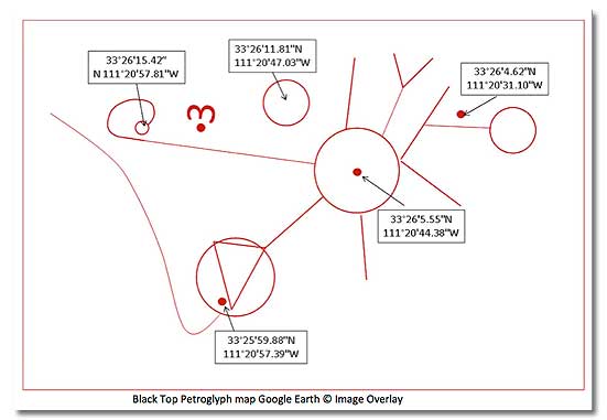
Black Top Petroglyph map Google Earth © Image Overlay
We used used Google maps to plan the ground trips
To correctly read the maps we had to know symbology. We knew the Mexicans used the metric system. We drew a lot of guidance from the work of Charles Kenworthy. There are several stratagems used repeatedly in the Peralta maps. They turned maps, so ‘up’ is not necessarily north – most of the time the top of the map is actually east. They flipped maps to make them mirror images. They would put several mapped areas together. They would put names of seemingly obscure things that were actually very important on the maps. These stratagems were things that only a scholar would know after studying the maps carefully.
The scale of the map was also always a concern. As we studied the maps and made field discoveries we observed that the lines could be trails or they could be topographical map lines. We perceived recognizable shapes that were in fact laid out on the ground like the images at Nazca. To understand any one map required us to imagine the symbols within each stratagem. Each time we thought we had a map's solution, we went to the Google Earth© tool to see if we could find the terrain that fit it or other evidence visible in satellite images.
Let us explain how we used Google Earth© to check a map's solution. We first pasted an image of the original map of interest on a blank slide using Microsoft© PowerPoint. We traced the map lines using red lines. We grouped the drawing and deleted the image, then selected a photographic adjustment tool, ours being Paintshop Pro©. We copied the grouped object in PowerPoint© and pasted it into Paintshop Pro© as a new image, then enhanced the contrast and colors of the image. Then we saved this image into a working directory as a jpeg file.
Next we opened Google Earth©. Once opened, we used the Google Earth© tool ‘Add Image Overlay’. We browsed the working directory where the image was stored and opened the file. Google Earth© has a window for object properties, and images can be adjusted for transparency. We next adjusted the transparency until we could see the terrain below clear enough to determine if the map matched the terrain. We slid, rotated and sized the overlaid image until we thought we have a match. Once a match was made we closed the object properties window and began inspecting it for details in the satellite images of Google Earth©, looking for evidence of activity.
Google Earth© has years of satellite images and that means different times of day as well as seasons. Experience has taught us to try them all. When we did have a point of interest we added an object from the standard Google Earth© library and labeled it accordingly. This is how we created our *.kmz files. We transfered these files to our GPS for hiking into the wilderness in order to find it on the ground and evaluate it.
We solved these maps using this technique, in the following order:
- The Ortiz map of Music Canyon
- The Petroglyph map on Black Top Mountain of Bluff Springs Mountain
- The Petroglyph map known as the Peralta Master Map for the region around Weavers Needle
- The Peralta Post Road map of 100 square miles within the Superstition Wilderness
- The Stone Cross that links the Post Road Map to the Latin Heart
- The Latin Heart, Map and Roman Numeral sides
- The Burbridge Map of the original Peralta Mines of the Superstition Area
- The Rose Map that is of the region from Florence along the Gila up to the Salt River
The Peralta Master Map is a prime example of many of the tricks in one map.

The Peralta Master Map Brought to the World’s Attention by Barry Storm
(Courtesy of the Superstition Mountain Historical Society)
The main tactics used in this map are that it is vertically flipped, topographical in nature, and it is in fact a collection of four maps of the region of Bluff Springs Mountain and Weavers Needle area. It is also a metric map. It has been somewhat defaced since the time of Barry Storm.

Peralta Master Map Analysis
Determining where the stones lead
To analyze the Stone Map we had to determine how the map pieces were organized. Two of the pieces are not maps, they are instructions. They are the Priest Stone and the Stone Cross text. Study of the Priest Stone revealed a riddle indicating how to use the maps; ‘Search the map, search the heart’. It has a secret heart in this map riddle, and the instructions tell us to search that area.

Instructions in the Riddle of the Priest Stone
When we searched for all the hearts of the true Stone Map we found a small heart embedded in the Post Road Map. The heart is a symbol that changes size depending on which piece it is on. We took this to mean that the one on the Post Road Map was a map of a larger area; the second, on the cross, was a smaller map that showed how to find where the Latin Heart Map's even smaller location existed; while the Latin Heart itself showed us where in the smaller location to search.

Nested Map Sequence
We repeated the Google Earth© tool process to position all the map pieces that remained. We needed to check our work. We numbered the posts of the Post Road Map from 1 to 18. We started numbering at Tobias as we read from Charles Kenworthy that Tobias was the position where the trails began. We measured the distance from post 2 to the large circle area using Google Earth on a trail we saw and it measured 3 km. We did the same for Post 18, the double circle post at the end of the trail. It measured 7 km. At this point we understood what the ‘equation’ was on the map. The equation was their notation for the map scale.
We also had to position the map so that the top was east. The breakthrough came by aligning one trail on the map with an existing trail that begins at Superstition Mountain along the western ridge of the wilderness. The map turned out to cover an area approximately ten miles by ten miles. We provide you an overlay of the Peralta trails and the existing hiking trails within the Superstition Wilderness area. The view is north to the top.

Click to enlarge
Comparison of Existing Trails and Peralta Trails of the Superstition Wilderness
Once all the map pieces were laid out in Google Earth© we plotted a route for aerial surveys using the experience of a friend and pilot. One flight would be by helicopter and one flight would be by a fixed wing Cessna. Helicopter routes were rather long in an attempt to follow the Post Road trail and check some areas related to other maps for evidence of activity. The Cessna flight was kept to the area of the Latin Heart and the nearby canyon described by Jacob Waltz. The helicopter flights would end where the Cessna flight was to be done. We have provided the GPS waypoints in Google Earth© for the aerial surveys so you can see where we flew. Each waypoint is a destination provided to the pilot in the form of a flight card. The pilot could take any safe route to put the observer on that station so photos could be taken.
A digital camera with a high powered telephoto lens was used in each of the aerial surveys and we took several thousand photographs. When these came back from the field we were able to locate evidence to support our interpretation. Because of that we prepared to hike into the wilderness for inspection at ground level.
We went back to our Google Earth© tool and inserted information regarding what we could observe from the air into the kmz files. These became the files that we downloaded into our GPS units for hikes. We also had to know what was already known to be in the area. We obtained information from Greg Davis, the archivist of the Superstition Mountain Historical Society. That is included in the kmz file as SMHS data. We also used the following site http://hikearizona.com/decoder.php?ZTN=237 to obtain recent information and the location of existing trails.
A Google Earth© file that you can use is provided to show you the two stages of work in planning. The first stage in planning and research involved aerial surveys, and the second stage was the planning and research for the hike, based on the results of the aerial survey. One of the most valuable products of the research and planning effort was a three foot by four foot map of the Latin Heart site to be carried in packs. It contained everything we wanted to look at and a high resolution topographical map that we produced using radar data from Google Earth©. One of our maps is in the Superstition Mountain Historical Society archives with Greg Davis.
Author's Biography: Robert L. Kesselring
Index to Articles
- History of the Mines and the Treasure
- Peralta Stone Map and Cross
- Research and Planning
- Ground Trips
- Summary
- Read comments on this article
Related DesertUSA Pages
Dating The Peralta stone maps
Lost Dutchman State Park
New Evidence Surfaces About the Lost Dutchman Mine
Lost Dutchman Found?
Lost Dutchman Mine: Part 2
Lost Dutchman Mine: Part 3
Are The Peralta Stones Map Fake ?
How to Turn Your Smartphone into a Survival Tool
7 Smartphone Apps to Improve Your Camping Experience
GPS Navigation Systems Can Be a Misleading Travel Companion
Twenty Six Tips for Surviving in the Desert
Heat Acclimation (Combating the Desert Heat)
Phoenix, Arizona
Globe, Arizona
CAUTIONARY NOTE: Health Advisory and Legal Disclaimer
Caution: Many people have died trying to find this treasure. The authors of this story prepared thoroughly with provisions and emergency planning prior to undertaking their trips. DesertUSA does not advise anyone to try to replicate their journey without a guide and extremely thorough preparations to include plans for water, food, shelter, guidance and communications. No amount of gold or treasure is worth your life.
NOTE: The Superstition Mountains are east of Apache Junction in Arizona and the area has been designated a Wilderness Area by Congress. This means all things within are protected by law. Anything other than hiking, camping and taking photos will require a permit from the National Forest Service. Therefore when we discuss the presence of treasure and mines please keep the law in mind, do not disturb archaeological sites.
If you would like to contact the authors for more information, please email dusa_feedback@DesertUSA.com. Please include "DesertUSA" in your subject line or we may not receive the email.
Related DesertUSA Pages
- How to Turn Your Smartphone into a Survival Tool
- 26 Tips for Surviving in the Desert
- Death by GPS
- 7 Smartphone Apps to Improve Your Camping Experience
- Maps Parks and More
- Desert Survival Skills
- How to Keep Ice Cold in the Desert
- Desert Rocks, Minerals & Geology Index
- Preparing an Emergency Survival Kit
Share this page on Facebook:
The Desert Environment
The North American Deserts
Desert Geological Terms


