Great Sand Dunes National Monument
Description
Overview | Climate/Maps | Activities
Cultural History
Native Peoples
Evidence of the Clovis culture, small bands of nomadic hunters who came into the valley during the spring, summer and fall months, dates back about 11,000 years ago.
The Ute ranged throughout Colorado, including the San Luis Valley, from the late 18th to early 20th century, but they established no permanent residence in the San Luis Valley. The first permanent dwellings in the San Luis Valley were log and adobe buildings of the 19th-century settlers
Exploration & Settlement
Don Diego de Vargas was probably the first European to view the dunes while searching the Sangre de Cristo Mountains for gold and other precious minerals in 1694. Various subsequent attempts were made to extract minerals from the dunes themselves with no apparent success.
Medano and Mosca Pass were used by early explorers, including Zebulon Pike (1807), Captain John Fremont (1848-49) and railroad surveyor Captain John Gunnison (1853). Pike described his first view of the sand dunes in his journal: "Their appearance was exactly that of a sea in a storm (except as to color) not the least sign of vegetation existing thereon."
Mosca Pass was used by many settlers to access the San Luis Valley, especially after gold was discovered in the San Juan Mountains to the west of the dunes. After obtaining a charter from the Territory of Colorado in 1871, Frank Hastings, who ,operated operated a store here near Boubidoux's old trading post, improved the trail and established a toll gate.
Ranchers and homesteaders began settling the valley using irrigation canals to raise fruits and vegetables for their own use. By the 1880s, as competition for grazing land grew, range wars broke out, leading to federal establishment of timber preserves, and eventually, the first national forests.
By 1900, farming, ranching and mining were the chief industries of the San Luis Valley. In 1927, Frank Wellington hand-dug a ditch from high mountain creeks to bring water to his homestead and to supply water to orchards, gardens, pastures and livestock. This and other canal systems in the vicinity of the Great Sand Dunes were extensive. Some were for irrigation, others provided water for mineral development.
Park History
This geologic wonderland, containing 39 square miles of dunes, became a national monument in 1932. With the passage of the Great Sand Dunes National Park and Preserve Act of 2000, resources now also include alpine lakes and tundra, six peaks over 13,000', ancient spruce and pine forests, large stands of aspen and cottonwood, grasslands, and wetlands--all habitat for diverse wildlife and Rocky Mountain plant species.
Natural History
Plants & Animals
In the San Luis Valley, with an elevation of about 8,000 feet, long, cold winters make for a short growing season. In this high and dry climate, where temperatures can fluctuate as much as 50 degrees degrees between day and night, there is a great diversity of plants and animals who make Great Sand Dunes National Monument their home.
Twenty different species of plants grow directly on the dunes, including Indian Rice Grass, Blowout Grass and Scurf Pea. In late summer, brilliant gold Prairie Sunflowers grow up to 4 feet high. These plants provide food and shelter for many insects, the most common dune inhabitant. Crickets, spiders and 4 species of beetles found nowhere else in the world avoid daytime's intense heat and sunlight by remaining deep in their burrows until night.
Kangaroo Rats live at the base of the dunes and surrounding shrub lands,which provide shade and shelter for many small animals, including rabbits, mice, ground squirrels, numerous birds and even Mule Deer. But most of the larger mammals live in sheltered areas of the surrounding mountains. Coyotes, Bobcats. Bears, Mountain Lions and Elk inhabit the Sangre de Cristo and use Medano Creek as a water source.
Montville and Wellington Ditch Trails and Mosca Creek are excellent bird watching areas. With their cat-like call, the Green-tailed Towhee bird often fools visitors into thinking that kittens are wandering in the desert shrub. The Visitor Center has a bird checklist available for a nominal fee.
Geology
The San Luis Valley, averaging less than 8 inches of precipitation a year, is the only true desert of the Colorado Rockies. Formed by the Rio Grande Rift , it is bordered on the west by the Tertiary volcanic San Juan Mountains, and on the east by the Precambrian granite of the Sangre de Cristo Mountains. A fault runs along the western base of the Sangre de Cristos.
The valley is filled with layer upon layer of sand, gravel, clay, lava and ash to a depth over 10,000 feet. About 12,000 years ago, when glaciers from the last Ice Age began to melt, the swollen Rio Grande River deposited glacial debris, sand and gravel across a large portion of the San Luis Valley. The Rio Grande, from its head waters in the San Juan Mountains, has been meandering through the valley, depositing sand ever since.
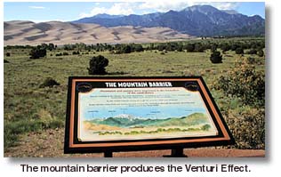
When prevailing southwest winds sweep across the valley, they carry sand from the sparsely vegetated surface toward the natural barrier of the Sangre de Cristos. Here, in a sheltered corner at the foot of the mountains, the wind funnels through three low passes -- Mosca, Music and Medano -- depositing sand as it loses velocity and rises.
Most of the sand consists of fine-grained, rounded quartz, pumice, ash, and lava from the San Juans. Sangre de Cristo sand, comprised of many rock types, is more coarse-grained because it does not travel as far. Sand grains from both sources range in size from 0.2 mm to 2 mm.
The oval-shaped dune field thus created -- the Great Sand Dunes-- is about 6 miles across with some dunes rising 700 feet above the valley floor. Medano Creek, running north and south of the dunes, helps regulate the size and position of the entire field.
The dune shapes are primarily of the transverse type, with a few crescent-shaped barcan dunes around the edges of the field and sporadic star dunes as well. The dunes are created in three ways; saltation, surface creep, and suspension.
Saltation is when sand grains bounce as they are transported by wind. This bouncing movement accounts for about 95% of the dune field. Surface creep occurs when sand grains collide with other grains, causing them to roll. Creep accounts for about 4% of sand movement.Suspension occurs when sand is blown high into the air. Suspension accounts for about 1% of dune formation.
Dunes have two slopes or "faces". The shallow, dipping side is the windward face. Sand blown from the windward face is deposited on the steeply dipping leeward side. Sand on the leeward side, or slipface, is subject to constant change, avalanching when the sand reaches its maximum angle of repose, 34 degrees.
The dunes of Great Sand Dunes National Monument appear darker than beach sand because magnetite, darker and heavier than most minerals, remains on the surface. Because magnetite usually indicates the presence of gold, prospectors in the early 1900s tried mining the dunes for "flour gold" but found it unprofitable.
Related DesertUSA Pages
- How to Turn Your Smartphone into a Survival Tool
- 26 Tips for Surviving in the Desert
- Death by GPS
- 7 Smartphone Apps to Improve Your Camping Experience
- Maps Parks and More
- Desert Survival Skills
- How to Keep Ice Cold in the Desert
- Desert Rocks, Minerals & Geology Index
- Preparing an Emergency Survival Kit
Share this page on Facebook:
The Desert Environment
The North American Deserts
Desert Geological Terms


