Great Sand Dunes National Monument
Things To Do
Visitors can go hiking on the dunes and several nature trails, observe and photograph flora, and picnic. Medano Creek, which flows at the base of the dunes during spring and early summer, allows for sand castle building, hiking, and even fishing. A picnic area at the base of the dunes has tables, grills, water and restrooms.
When exploring the dunes, bring drinking water, shoes, sunscreen and other necessities., since the sand temperature can reach 140 degrees F. With an elevation is 8,200 feet above sea level, some visitors have been known to experience headaches, dehydration, fatigue, rapid heartbeat and shortness of breath while exploring the dunes.
The only restrictions for activities on the dunes are:
- Stay off the vegetated areas
- Take home whatever you carry in with you, especially cardboard
Auto Touring
Medano Pass Primitive Road requires 4-wheel-drive. It starts in the Monument and that goes north along Medano Creek to Medano Pass and the Rio Grande National Forest, offering spectacular views of the pass. Primitive picnic areas with no water are along the road.
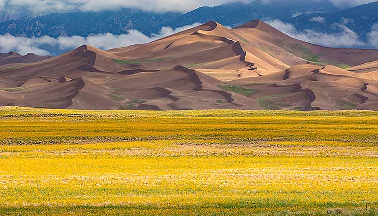
Wildflowers
Hiking & Trails
Hiking the dunes is one of the most popular activities in the Monument. Allow at least 2 hours to do so. There are no trails on the dunes, but you may travel by foot anywhere you wish. Walking is easier on the ridge lines where the footing is slightly more solid, not on the slipfaces where the sand is very loose and soft. A few park trails allow hiking and horseback riding away from the dunes.
Montville Nature Trail
This 1/2-mile trail is a self-guided loop conveniently located near facilities and circling the lower portion of Mosca Canyon. Spectacular views of the dunes can be seen from high points along the trail. A 16-stop trail guide is available at the Visitor Center bookstore.
Little Mendano Creek Trail
A one-way, 5 1/2-mile trail beginning in Loop 2 of the campground and ending at Little Medano Creek. From here, Sand Creek Trail continues another 6 miles west along the base of the foothills where the dunes meet the mountains. Eight backcountry campsites are located along these trails. A free backcountry permit can be obtained from the Visitor Center.
Mosca Pass Trail
This trail intersects the Montville Nature Trail and is a 7-mile round-trip hike to the top of the pass. with wonderful views of the area. Mosca Pass Trail has an elevation gain of 1,463 feet, through a variety of habitats including pinyon-juniper forests, aspen groves, spruce-fir forests and lush grasslands near the top of the pass.
Wellington Ditch Trail
This 1-mile trail is accessed from Loop 3 of the campground (park at Amphitheater parking area) or from the north side of Montville Trail. This trail is named "Wellington" after a homesteader who settled here in the 1920s. Parts of the trail follow original his hand-dug irrigation ditch.
Horseback Riding
There are no guided trips or horseback rentals, however, people may bring their own stock and ride in the Monument. Inquire about where to park a trailer. Some restrictions apply:
- A free permit must be obtained from the Visitor Center.
- Ride away from the main use areas (dunes parking lot and high dune, campground, and picnic areas).
- Montville and Wellington trails are closed to horses.
- Overnight stock use is permitted only in the back country and requires carrying weed-free hay.
- It is recommended that horses be fed weed-free hay 24 hours prior to riding in the Monument.
- Clean up the loading area before you leave.
Biking
With so few roads and so much sand there is not much opportunity for bicycling in the monument. Mountain bikes are permitted on the Medano Pass Primitive Road, but soft sand makes it more of a walk than a ride.
All trails in the monument and adjacent to the U.S. Forest Service wilderness are closed to bicycles. A bike trail is planned near Zapata Falls for the future.
Skiing/Sandboarding
During the winter months there is often enough snow to cross-country ski the dunes, trails or Medano Pass Primitive Road. Do not to use wax on your skies to avoid polluting the creeks.
Video - Sandboarding and Sand Sledding at Great Sand Dunes
Overview | Climate/Maps | Description
Related DesertUSA Pages
- How to Turn Your Smartphone into a Survival Tool
- 26 Tips for Surviving in the Desert
- Death by GPS
- 7 Smartphone Apps to Improve Your Camping Experience
- Maps Parks and More
- Desert Survival Skills
- How to Keep Ice Cold in the Desert
- Desert Rocks, Minerals & Geology Index
- Preparing an Emergency Survival Kit
Share this page on Facebook:
The Desert Environment
The North American Deserts
Desert Geological Terms


