Borrego Badlands
Anza-Borrego Desert State Park, California
Map of the Borrego Badlands

About This Video
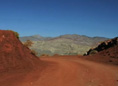
The Borrego Badlands are one of the most rugged and remote regions of Anza-Borrego Desert State Park, located east of Borrego Springs in Southern California. In this short DesertUSA video, you’ll see aerial and ground-level footage of these ancient eroded formations carved by wind and water. The Badlands are known for their layered sedimentary rock, fossil-rich soils, and expansive desert washes like Font’s Point and Palm Wash. This region offers a glimpse into the region’s prehistoric past and is a favorite among hikers, photographers, paleontologists, and desert explorers. Learn more about California's badlands and their unique place in North American desert geology.
Videos you might also like:
 Fonts
Point - Borrego Badlands Centered in the arid Borrego Badlands due east of the Visitors Center
between County Road S-22 and Route 78, four million years of geologic and paleontologic
history are exhibited across a stark desert landscape. Join the crew of DesertUSA
and take a road trip to Fonts Point, maybe the best place in North America to
view sediments of the Pliocene and Pleistocene Epochs.
Fonts
Point - Borrego Badlands Centered in the arid Borrego Badlands due east of the Visitors Center
between County Road S-22 and Route 78, four million years of geologic and paleontologic
history are exhibited across a stark desert landscape. Join the crew of DesertUSA
and take a road trip to Fonts Point, maybe the best place in North America to
view sediments of the Pliocene and Pleistocene Epochs.
Death Valley - Titus Canyon As Titus Canyon Road in Death Valley reaches the foothills, it starts to climb and meander among the sagebrush and red rock outcroppings. The road becomes steeper and narrower as it approaches Red Pass, amply named for its red rocks and dirt. Enjoy the ride!
Share this page on Facebook:
The Desert Environment
The North American Deserts
Desert Geological Terms


Click here to see current desert temperatures!