Natural Bridges National Monument
Camping - Lodging - Weather - Nearby
Lodging
There is no lodging in the Monument. Lodging is available in Blanding and Monticello Utah.
Camping
Park Campgrounds - Fee
The Monument's 13-site campground is open year-round, but it is not cleared of snow in the winter. No reservations are accepted and there is no group site available. Wood fires are permitted, but no wood gathering is allowed inside the Monument. Vehicles over 26 feet long are not allowed in the campground. All sites fill by early afternoon from early March through late October so arrive by noon to claim a campsite for the night. Rangers at the visitor center can give directions to nearby camping areas.
Park Backcountry Camping
There is no backcountry camping in the Monument.
Additional Camping
Additional camping in this area is not close at hand. Camping is available at Goosenecks State Park 40 miles south; Hite Marina in Glen Canyon National Recreation Area, about 50 miles west; and in the Abajo Mountains 75 miles east. Check with the rangers for nearest available camping outside the park.

Climate
At an elevation of 6,500 feet above sea level, summers are very warm and winters quite cold. Clothing should be varied throughout the year. Mild winter days may make hiking in light clothing possible, but below zero temperatures are not unusual in the winter. Rain is a possibility at any time, especially in spring and late summer, so rain gear is recommended.
Summer: highs 85 degrees to 90 degrees, lows 50 degrees to 60 degrees, thunderstorms possible.
Fall: highs 60 degrees to 75 degrees, lows 40 degrees to 50 degrees, usually mild, snow late fall.
Winter: highs 40 degrees to 50 degrees, lows 10 degrees to 30 degrees, snow likely.
Spring: highs 50 degrees to 70 degrees, lows 20 degrees to 40 degrees, usually mild, snow possible until June.
Getting There
By Auto
From the north/east, take Highway 191 to Blanding, Utah. Travel west 35 miles on Utah Highway 95, then north 4 miles on Utah Highway 275, which ends at the Monument.
From the north/west take Highway 95 east from Hanksville, Utah, 93 miles to Highway 275, then 4 miles north to the Monument.
From the south, take Highway 163 to Mexican Hat, Utah. Travel north on Highway 261, 38 miles to Highway 95. Turn west on Highway 95, proceed 1.5 miles to Highway 275, then north 4 miles to the Monument.
NOTE: Three miles of highway 261 are unpaved and narrow, with a 10% grade and is not recommended for motorcycles, oversize vehicles, or vehicles pulling trailers.
There is no public transportation to or from Natural Bridges.
Air
Commercial air service is available to Moab, Utah; Cortez, Durango, and Grand Junction, Colorado; Farmington, New Mexico; and Flagstaff, Arizona.
Bus
Bus service is available in Durango, Colorado; Flagstaff, Arizona; and Grand Junction, Colorado.
Train
Amtrak serves Thompson, Utah, located about 150 miles from Natural Bridges, but there is no connecting public transportation from the train station.
General Information
Rates & Fees
Visit park website for all current fees
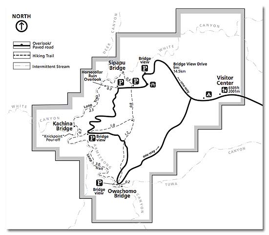
The Monument is open every day of the year. The visitor center closes for major holidays during winter months. The nine mile scenic drive is open every day from early morning until about 30 minutes past sunset.
Visitor Center
Hours: Summer: 8:00 AM to 6:00 PM
Early spring and late fall: 8:00 AM to 5:00 PM
Winter: 9:00 AM to 4:30 PM
Rest rooms and water are available 24 hours a day. Water is not available elsewhere in the Monument.
Resources
- Related Books & Gifts - Trading Post
- Prehistoric Desert Peoples
- The Anasazi
- The Anasazi Ruins of Grand Gulch, Utah
Near By
Cities & Towns
- Blanding, Utah: 40 miles east.
- Mexican Hat, Utah: 40 miles south.
- Kayenta, Arizona: 89 miles.
- Moab, Utah: 110 miles northeast.
- Cortez, Colorado: 121 miles east.
Parks & Monuments
- Goosenecks State Park: 40 miles south.
- Canyonlands National Park (Needles District): 74 miles northeast.
- Monument Valley, Arizona: 66 miles south.
- Arches National Park: 115 miles northeast.
- Navajo National Monument: 117 miles south.
- Capitol Reef National Park: 116 miles west.
- Hovenweep National Monument: 80 miles east.
- Mesa Verde National Park: 133 miles east.
- Edge of the Cedars State Park: 40 miles east.
Recreation & Wilderness Areas
- Glen Canyon NRA (Hite Marina): 50 miles west.
- Glen Canyon NRA (Halls Crossing): 59 miles southwest.
- Manti-La Sal National Forest: 7 miles notheast
- Grand Gulch Primitive Area: 15 miles south
Historic & Points of Interest
- Mule Canyon Ruins: 20 miles east
- Butler Wash Ruins Overlook: 26 miles east
Back to Main Page
Related DesertUSA Pages
- How to Turn Your Smartphone into a Survival Tool
- 26 Tips for Surviving in the Desert
- Death by GPS
- 7 Smartphone Apps to Improve Your Camping Experience
- Maps Parks and More
- Desert Survival Skills
- How to Keep Ice Cold in the Desert
- Desert Rocks, Minerals & Geology Index
- Preparing an Emergency Survival Kit
Share this page on Facebook:
The Desert Environment
The North American Deserts
Desert Geological Terms


