The Mogollon
Anasazi - Hohokam - Mogollon - Sinagua
by Jay W. Sharp
The Mogollon
The Mogollon division of the Puebloan people made a home in the high Chihuahuan Desert basins and the forested mountain ranges – perhaps the most geologically and ecologically varied landscape in the United States. The mountain ranges, with peaks as high as 12,000 feet in elevation, run north and south, roughly parallel, and they embrace the desert basins, with river valleys as low as 1000 feet in elevation. The land reflects the geologically recent torment of continental rifting, structural fracturing, volcanism, erosion and sedimentation.

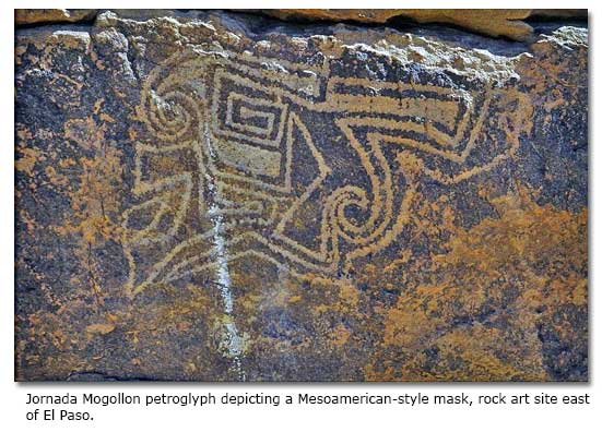
Several Mogollon groups clustered east and west of what is today the New Mexico and Arizona border, and they extended southward into Chihuahua and Sonora. Other Mogollon groups, generally called the Jornada Mogollon, took up primary residence across southeastern New Mexico and northern Chihuahua.

At their peak, around the beginning of the second millennium, the western Mogollon constructed large pueblos with above-ground masonry structures, one- or two-story clusters of rooms, often with common walls. In a few instances, for example, the Grasshopper Ruin in Arizona, they built pueblos with 500 or more rooms that faced an open plaza. In these larger communities, the Mogollon constructed great kivas, most with rectangular floor plans but a few with circular floor plans, in the community plaza.
In a flowering of creativity, the Mogollon to the west produced new forms of ceramics. In particular, those we call “Mimbres” painted geometric designs and storytelling images on pottery surfaces, producing black-on-white ceremonial bowls that are now world-famous examples of the art of the prehistoric people of America.
Meanwhile, the Jornado Mogollon, farther east, followed a cultural course similar to that of their cultural kin to the west, although with some differences. At their peak, the Jornada Mogollon also built above-ground pueblos, sometimes large and possibly fortified.
Across their range, in rudimentary observatories and mountain crevasses split by the rays of the sun, the Jornada Mogollon tracked the annual passage of our stars and the coming and going of the seasons. In sequestered rock alcoves, caves and village ceremonial chambers, their holy men – or shamans – cached sacred artifacts, their instruments of magic. They established widespread trade networks, which reached from the High Plains westward to Arizona and southward into Chihuahua.

Over the centuries, the Jornada Mogollon communities – usually constructed primarily of adobe – have largely melted into the desert floor, but these Puebloans still left us with enduring and stunning galleries of mysterious and evocative images chiseled or painted on surfaces of stone, perhaps most famously at the Three Rivers National Monument site, on the western side of southern New Mexico’s Sacramento Mountains, and at the Hueco Tanks State Historical Park site, about 35 miles east of El Paso. Ironically, for reasons that archaeologists may never fully comprehend, the rise of the Mogollon pueblo communities appeared to telegraph their collapse around the beginning of the 15th century.
Anasazi - Hohokam - Mogollon - Sinagua
More DesertUSA articles


Share this page on Facebook:
The Desert Environment
The North American Deserts
Desert Geological Terms


